
Carronbridge


Enclosure (Period Unassigned)
Site Name Carronbridge
Classification Enclosure (Period Unassigned)
Canmore ID 65199
Site Number NX89NE 60
NGR NX 86905 97851
Datum OSGB36 - NGR
Permalink http://canmore.org.uk/site/65199


- Council Dumfries And Galloway
- Parish Morton
- Former Region Dumfries And Galloway
- Former District Nithsdale
- Former County Dumfries-shire
NX89NE 60 868 978.
Shown as Roman Fortlet (R) (Site of) on OS 6" (Prov) 1957
Excavations in 1953-4 revealed a sub-rectangular enclosure of about 0.45 acres surrounded on three sides by a single ditch 2.75m in width and 1.4m deep, with an internal bank 4.9m wide and an entrance 4.5m wide in the south side. No remains of the bank or ditch were discovered on the
N side of the enclosure. Soil disturbance and the presence of post-holes suggested occupation within the enclosure and a sherd of 'Votadinian' pottery was recovered from a burnt post-hole sealed by cobbling. Although the excavators believed the site to be of Roman date, there is no convincing evidence to support this, and the W ditch of the
enclosure is apparently overlain by the Roman Temporary Camp (NX 89 N E 4)
J Clarke and A B Webster 1954
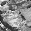
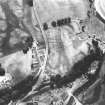
The site is visible on Air photographs.
About half of this enclosure was excavated in 1989. The ditch was V-shaped, with a square-sectioned 'ankle breaker' running along the bottom. The sides of the enclosure were straight, and the SE angle curved. The entrance faced S, and was formed by a simple break in the ditch. Only three internal features were recognised (i) a post-trench was located inside, and parallel to the enclosure ditch; (ii) an oven was built on the inner lip of the ditch; and (iii) a shallow circular pit.
In 1990 the intersection of this enclosure with Roman camp NX89SE 4 was excavated. The palisade slot (i) noted earlier was seen to continue around the W and S sides of the enclosure. This enclosure was clearly shown to have had a separate, earlier existence from the Roman camp, but there is no clear evidence to show whether it is Roman or native in origin. The ditch was clearly cut by the marching camp titulus and ditch at a time when it, ie the enclosure ditch, was about half full.
No other internal features were found.
D A Johnston 1989; 1990a; 1990b.
Cropmarks of a square, double ditched Iron Age/Romano-British enclosure (NX89NE 59), a Roman temporary camp (NX89NE 4) and another sub-rectangular enclosure (NX89NE 60) were excavated in advance of road building. All the monuments were plough damaged. The third and earliest enclosure was defended by a ditch and palisade; the temporary camp re-used part of its ditch. An oven found within the third enclosure was probably associated with the temporary camp.
D A Johnston, 1994
Excavation (1989 - 1990)
About half of this enclosure was excavated in 1989. The ditch was V-shaped, with a square-sectioned 'ankle breaker' running along the bottom. The sides of the enclosure were straight, and the SE angle curved. The entrance faced S, and was formed by a simple break in the ditch. Only three internal features were recognised (i) a post-trench was located inside, and parallel to the enclosure ditch; (ii) an oven was built on the inner lip of the ditch; and (iii) a shallow circular pit.
In 1990 the intersection of this enclosure with Roman camp NX89SE 4 was excavated. The palisade slot (i) noted earlier was seen to continue around the W and S sides of the enclosure. This enclosure was clearly shown to have had a separate, earlier existence from the Roman camp, but there is no clear evidence to show whether it is Roman or native in origin. The ditch was clearly cut by the marching camp titulus and ditch at a time when it, ie the enclosure ditch, was about half full.
No other internal features were found.
D A Johnston 1989; 1990a; 1990b.
Aerial Photographic Transcription (23 April 2012 - 24 April 2012)
Watching Brief (29 July 2019)
A programme of archaeological monitoring works was undertaken on the 29th July 2019 in respect of works at Carronbridge near Thornhill in Dumfries & Galloway. The works comprised a project to upgrade the Penpont 11kV
Overhead Line.
A section of the works (poles 18; 19 & 20) required to be undertaken within an area recognised as being of national importance and designated as a Scheduled Monument under the Ancient Monuments and Archaeological Areas Act (1979) relating to Carronbridge Roman Fortlet and enclosures at Carronbridge (SM4093). The monument comprises the remains of a fortlet and enclosures which are visible as cropmarks on aerial photographs.
Archaeological works were required as there was potential to affect surviving sub-surface archaeological features or deposits of national significance and / or enable recovery of unstratified finds in previously disturbed ground. The archaeological works involved the monitoring of the
excavation of three pole pits (18; 19 & 20) and four stay wire pits (one for pole 18; one large pit for pole 19 and two pits for pole 20).
The excavations revealed very sterile pits which all contained fairly lose fills and no significant archaeological remains of finds were identified during the course of the monitoring works.
Information from OASIS ID - rebeccas1-397189 (R Shaw) 2019

