
Carronbridge


Settlement (Period Unassigned), Brooch (Period Unassigned), Melon Bead (Period Unassigned), Penannular Brooch (Bronze)(Period Unassigned)
Site Name Carronbridge
Classification Settlement (Period Unassigned), Brooch (Period Unassigned), Melon Bead (Period Unassigned), Penannular Brooch (Bronze)(Period Unassigned)
Canmore ID 65197
Site Number NX89NE 59
NGR NX 86989 97716
Datum OSGB36 - NGR
Permalink http://canmore.org.uk/site/65197


First 100 images shown. See the Collections panel (below) for a link to all digital images.
- Council Dumfries And Galloway
- Parish Morton
- Former Region Dumfries And Galloway
- Former District Nithsdale
- Former County Dumfries-shire
NX89NE 59 8699 9770
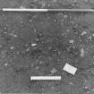
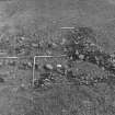
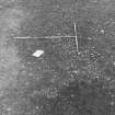
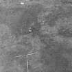
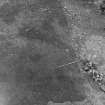
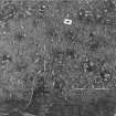
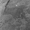
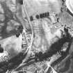
The site is visible on aerial photographs.
(Undated) information in NMRS.
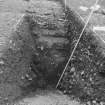
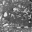
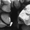
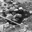
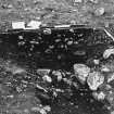
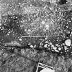
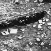
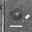
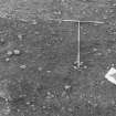
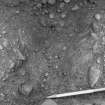
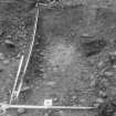
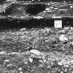
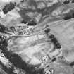
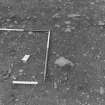
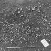
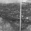
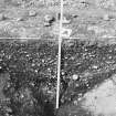
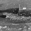
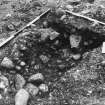
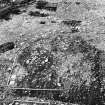
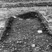
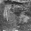
A double-ditched settlement, square on plan, is revealed by cropmarks; the E side has been lost under the modern road. Excavations in 1953-4 showed that there is an entrance to the N, (where the ditches become 'scooped out hollows') flanked by a palisade which continues along the inner edge of the inner ditch. The interior was found to contain at least one round house and traces of other occupation. It was evident that the settlement was of multiphase construction.
J Clarke and A B Webster 1954
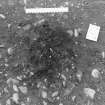
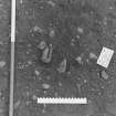
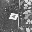
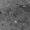
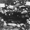
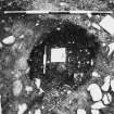
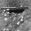
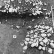
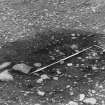
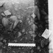
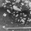
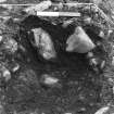
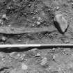
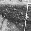
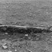
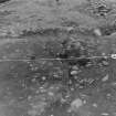
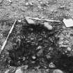
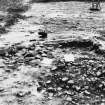
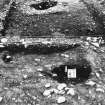
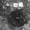
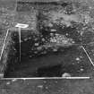
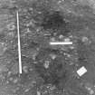
Excavation in 1989 showed that this consists of two rectangular ditches enclosing a series of round structures. The chronological relationship between the two rectangular ditches was unclear, though the inner ditch may be secondary as it cuts a series of post-trenches and gullies in the entrance area. A line of post-holes at irregular intervals was recognised in two places on the E side of the enclosure. This seems more like a fence than a palisade, and may possibly represent another enclosure phase, but it respects the inner ditch to such an extent that it is more likely to be contemporary with it. The NE quadrant of the inner enclosure contains a palimpsest of post-trenches, gullies and post-holes which represent between three and four round houses, none of which are contemporary with any of the others. Three of the houses have recognisable entrances, all facing E, towards the entrance of the enclosure. One entrance is formed by massive out-turned terminals, creating a porch. The southern house is cut by one of a group of shallow hollows containing large quantities of charcoal and in one case a large lump of slag. A melon head was found in a deposit sealing one of these features. The hollows are in turn cut by a deep V-shaped ditch which forms a penannular enclosure, 14m internal diameter, situated in the SE quadrant of the main enclousre. A large round structure stood in the interior, represented by a post-trench, nearly 1m deep, with an inturned entrance which, like that of the penannular enclosure, faces N. Two bronze brooches were found in the penannular enclosure; a fibula (illustrated in Johnston 1990a, fig. 15) from the upper fill of the ditch, and an unstratified penannular brooch of the 7th century AD from between the ditch and post-trench. Neither necessarily dates the enclosure.
D A Johnston 1989; D A Johnston 1990a.
In 1990 the remainder of the NE quadrant was excavated, and further details of the roundhouse complex were revealed. The largest roundhouse had two entrances, one facing E towards the main gate of the enclosure and a smaller one facing W. A ring of post-holes surrounded the N side of this house, and it contained two small pits.
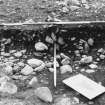
Between the large roundhouse and the inner ditch lay a complex of features surrounding a bowl furnace, probably used for iron-smelting. Another complex on the other side of the ditch was probably associated with the furnace, neither is likely to be contemporary with the inner ditch.
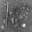
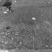
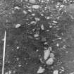
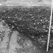
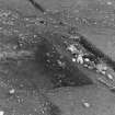
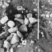
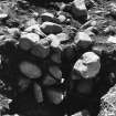
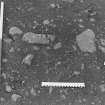
The approximate position of the inner edge of the ditch was marked by large stones positioned at approximately 5m intervals, deposited after the ditch was full. The function of these stones is obscure.
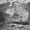
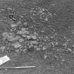
The SW quadrant was sampled, but no features were recognised. One of the hollows to the S of the roundhouse complex was re-excavated. It is possible that this hollow is a grubenhaus. It is a sub-oval feature about 6m long. A post-hole was recognised at the S end but none at the N end.
Sponsor: HBM.
D A Johnston 1990b.
Cropmarks of a square, double ditched Iron Age/Romano-British enclosure (NX89NE 59), a Roman temporary camp (NX89NE 4) and another sub-rectangular enclosure (NX89NE 60) were excavated in advance of road building. All the monuments were plough damaged. The square enclosure had three main enclosure phases. It contained six intersecting circular buildings, one of which was surrounded by a large ditch and three sunken features with complex, charcoal rich fills. A cobbled surface (probably a Roman road) (NX89NE 80.01) crossed its south east corner. Radiocarbon dates from the enclosure ranged from 145BC to AD 415; earlier activity was dated to between 1285 and 230BC. A brooch, sword and sickle, deposited probably in the ninth or tenth century AD, were found within the enclosure.
D A Johnston, 1994
Excavation (1989)
Excavation in 1989 showed that this consists of two rectangular ditches enclosing a series of round structures. The chronological relationship between the two rectangular ditches was unclear, though the inner ditch may be secondary as it cuts a series of post-trenches and gullies in the entrance area. A line of post-holes at irregular intervals was recognised in two places on the E side of the enclosure. This seems more like a fence than a palisade, and may possibly represent another enclosure phase, but it respects the inner ditch to such an extent that it is more likely to be contemporary with it. The NE quadrant of the inner enclosure contains a palimpsest of post-trenches, gullies and post-holes which represent between three and four round houses, none of which are contemporary with any of the others. Three of the houses have recognisable entrances, all facing E, towards the entrance of the enclosure. One entrance is formed by massive out-turned terminals, creating a porch. The southern house is cut by one of a group of shallow hollows containing large quantities of charcoal and in one case a large lump of slag. A melon head was found in a deposit sealing one of these features. The hollows are in turn cut by a deep V-shaped ditch which forms a penannular enclosure, 14m internal diameter, situated in the SE quadrant of the main enclousre. A large round structure stood in the interior, represented by a post-trench, nearly 1m deep, with an inturned entrance which, like that of the penannular enclosure, faces N. Two bronze brooches were found in the penannular enclosure; a fibula (illustrated in Johnston 1990a, fig. 15) from the upper fill of the ditch, and an unstratified penannular brooch of the 7th century AD from between the ditch and post-trench. Neither necessarily dates the enclosure.
D A Johnston 1989; D A Johnston 1990a.
Aerial Photographic Transcription (23 April 2012 - 24 April 2012)
Watching Brief (29 July 2019)
A programme of archaeological monitoring works was undertaken on the 29th July 2019 in respect of works at Carronbridge near Thornhill in Dumfries & Galloway. The works comprised a project to upgrade the Penpont 11kV
Overhead Line.
A section of the works (poles 18; 19 & 20) required to be undertaken within an area recognised as being of national importance and designated as a Scheduled Monument under the Ancient Monuments and Archaeological Areas Act (1979) relating to Carronbridge Roman Fortlet and enclosures at Carronbridge (SM4093). The monument comprises the remains of a fortlet and enclosures which are visible as cropmarks on aerial photographs.
Archaeological works were required as there was potential to affect surviving sub-surface archaeological features or deposits of national significance and / or enable recovery of unstratified finds in previously disturbed ground. The archaeological works involved the monitoring of the
excavation of three pole pits (18; 19 & 20) and four stay wire pits (one for pole 18; one large pit for pole 19 and two pits for pole 20).
The excavations revealed very sterile pits which all contained fairly lose fills and no significant archaeological remains of finds were identified during the course of the monitoring works.
Information from OASIS ID - rebeccas1-397189 (R Shaw) 2019

