
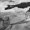
Loch Mannoch


Burial Cairn (Prehistoric)
Site Name Loch Mannoch
Classification Burial Cairn (Prehistoric)
Canmore ID 64183
Site Number NX66SE 3
NGR NX 6621 6147
Datum OSGB36 - NGR
Permalink http://canmore.org.uk/site/64183


- Council Dumfries And Galloway
- Parish Tongland
- Former Region Dumfries And Galloway
- Former District Stewartry
- Former County Kirkcudbrightshire
NX66SE 3 6621 6147.
(NX 6621 6147) Cairn (NR)
OS 6"map, (1958)
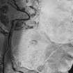
A large circular cairn about 66' in diameter and from 4' to 6' in height. A hollow in the top indicates an excavation, but neither cist nor chamber is exposed.
RCAHMS 1914, visited 1911
A large grass-covered cairn as described by RCAHMS with a diameter of 23.0m.
Revised at 25".
Visited by OS (WDJ) 5 August 1968
Field Visit (5 March 1990)
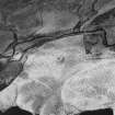
This cairn, which measures 19m in diameter and stands about 1.5m high, is situated on a natural knoll. The centre has been robbed and there is a spill of stones down the side. The vicinity of the cairn has been ploughed. The cairn is at the S end of a linear cemetery of three cairns (NX66SE 13 and NX66SE 51).
Visited by RCAHMS (DCC) 5 March 1990.

