
Pricing Change
New pricing for orders of material from this site will come into place shortly. Charges for supply of digital images, digitisation on demand, prints and licensing will be altered.
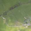
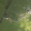
Cairnholy


Chambered Cairn (Neolithic)
Site Name Cairnholy
Classification Chambered Cairn (Neolithic)
Alternative Name(s) Cairnholy Ii; Cairn Holy 1; Kirkdale; Galdus's Tomb
Canmore ID 63705
Site Number NX55SW 1
NGR NX 51820 54045
Datum OSGB36 - NGR
Permalink http://canmore.org.uk/site/63705


- Council Dumfries And Galloway
- Parish Kirkmabreck
- Former Region Dumfries And Galloway
- Former District Wigtown
- Former County Kirkcudbrightshire
NX55SW 1 51820 54045
(NX 5181 5403) Cairn Holy (NR)
OS 6" map (1957)
For chambered cairn (Piggott and Powell Cairnholy I and Henshall KRK 2) situated downhill and to the S, at NX 51760 53890, see NX55SW 2.
Location formerly entered as NX 5181 5403.
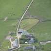
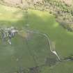
(Piggott and Powell Cairnholy II). This Clyde-type chambered cairn, the one from which the farm takes its name, is traditionally the tomb of Caldus, the mythical Scottish King. Its outline is roughly oblong, measuring 70' x 40' and it is nowhere more than 2' high. The dunuded bipartite chamber is at the NE end of the cairn, measuring 18' long, including a pair of portal stones, there was also a very shallow v-shaped forecourt.
Excavated by Piggott and Powell, the rear chamber had been previously robbed, and the other disturbed, but a leaf-shaped arrowhead and a flint knife of Arran-type came from the filling, along with secondary sherds of Beaker pottery, the finds are now in the National Museum of Antiquities of Scotland (NMAS Accession nos. EO 831-842). Under guardianship.
S Piggott and T G E Powell 1951; J G Scott 1969; A S Henshall 1972, no. KRK 3.
As described and planned.
Resurveyed at 1:2500.
Visited by OS (RD) 23 March 1972.
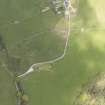
NX 5183 5403 Archaeological monitoring was undertaken in November 2004 during the excavation of a very shallow (50mm) trench for the concrete base of a new information board, c 10m SE of the northernmost of the two chambered cairns at Cairnholy (NX55SW 1). No finds or features of archaeological significance were found.
Archive to be deposited in NMRS.
Sponsor: HS.
S Coulter 2005
Publication Account (1986)
On their hillside setting above Wigtown Bay, these two chambered tombs possess a range of dramatic visual qualities that are apparent under all lighting conditions. The lower or southern cairn (Cairnholy I) is quite majestic with its pillared eastern facade; set on a knoll some 150m to the north, Cairnholy II is not so grand but its portals and inner capstone give it a more mysterious aspect. These tombs are the best of the Clyde group of long cairns in the region, and their excavation in 1949 produced a rich assemblage of finds (RMS).
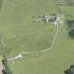
Cairnholy I has been robbed of most of its overlying cairn material. In its final prehistoric form it was a long straight-sided mound, about 43m by 10m, aligned along the contour and extending beyond the present road. The inner burial-chamber with its massive side-slabs probably represents the nucleus of the tomb, and was covered with a small cairn. To this was later added an ante-chamber, and then a concave 'homed' facade comprising eight tall pillars. The forecourt seems to have been designed as a setting for ritual ceremonies. At least six fIres had been lit in this area before it was blocked for good, and indications of pottery-associated offerings were uncovered. A fragment of jadeite axe-blade found in the outer compartment may also have been related to these ceremonies.
There is a large slab in the inner chamber which bears a weathered cup-mark with four or five concentric rings; it possibly roofed the last (cist) burial within thiscompartment A small cup-and-ring-marked slab found in the inner chamber is now in RMS.
The cairn which originally covered Cairnholy II has been much denuded, leaving only its irregular oblong outline around the summit of the hillock. Most of the stones evidently went into the construction of dykes and buildings in the late 18th century, but robbing stopped at the large slabs of the tomb itself. It consists of slab-sided inner and outer (perhaps secondary) chambers, the inner still retaining its large capstone. The entrance is flanked by tall and leaning portal stones, one 2.9m high, the other possibly broken; like Cairnholy I, it had a large closing stone, now recumbent Excavated frnds from the outer compartment included a leaf-shaped arrowhead, a flint knife and Beaker pottery, thus showing a similar range of users to that of the neighbouring tomb.
Information from ‘Exploring Scotland’s Heritage: Dumfries and Galloway’, (1986).
Watching Brief (10 November 2004)
NX 5183 5403 Archaeological monitoring was undertaken in November 2004 during the excavation of a very shallow (50mm) trench for the concrete base of a new information board, c10m SE of the northernmost of the two chambered cairns at Cairnholy (NX55SW 1). No finds or features of archaeological significance were found.
S Coulter 2005
Sponsor: Historic Scotland
Kirkdale Archaeology

