
Following the launch of trove.scot in February 2025 we are now planning the retiral of some of our webservices. Canmore will be switched off on 24th June 2025. Information about the closure can be found on the HES website: Retiral of HES web services | Historic Environment Scotland
Braid Fell


Bomb Crater(S) (20th Century), Bombing Target (20th Century)
Site Name Braid Fell
Classification Bomb Crater(S) (20th Century), Bombing Target (20th Century)
Canmore ID 143752
Site Number NX16NW 111
NGR NX 1135 6760
Datum OSGB36 - NGR
Permalink http://canmore.org.uk/site/143752


- Council Dumfries And Galloway
- Parish Inch
- Former Region Dumfries And Galloway
- Former District Wigtown
- Former County Wigtownshire
NX16NW 111 1135 6760
See also NX16NW 110.00
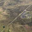
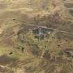
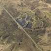
On the W side of the single track road that goes over Braid Fell is a second WWII bombing target (see also NX16NW 110). The area was constructed to look like a factory, but has now been removed entirely. A concrete arrow survives nearby. The factory required to be rebuilt after bombing had taken place and was used by several squadrons, notably 633.
J A Guy 1999; NMRS MS 810/6, 230 (vol.1)
Nothing survives within a fenced area of this World War II bombing target.
The bombing target is visible on a postwar RAF vertical air photograph (106G/UK987, 4207, flown 9 November 1945) and the surrounding area is heavily marked with bomb craters. The 'factory' was built with a flat roof.
Both the 'factory' and the bombing wall (NX16NW 110.00) are related to the area being used for bombing practice and include the target indicator arrows at the wall and beside the road (NX16NW 110.01).
Visited by RCAHMS (DE), March 2004
The bombing target is also visible on a RAF WW II vertical air photograph (D309, 5171, flown 4 July 1941),, which shows the dummy factory under construction and partially roofed.
Information from RCAHMS (DE), October 2005

