
Drumflower - Dunragit


Quarry Pit(S) (Roman), Roman Road (Roman)
Site Name Drumflower - Dunragit
Classification Quarry Pit(S) (Roman), Roman Road (Roman)
Canmore ID 78916
Site Number NX15NW 75.01
NGR NX 14381 57701
NGR Description Centre
Datum OSGB36 - NGR
Permalink http://canmore.org.uk/site/78916


- Council Dumfries And Galloway
- Parish Old Luce
- Former Region Dumfries And Galloway
- Former District Wigtown
- Former County Wigtownshire
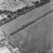
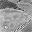
NX15NW 75.01 1425 5772 to 1498 5749. RR 8. Formerly RX 23.
See also NX15NE 70.00 and NX15NE 75.00.
Drumflower - Dunragit Quarry-pits; Roman Road
Drumflower section 1425 5772 - 1452 5765
Dunragit section 1487 5753 - 1510 5745 (See NX15NE 70.01).
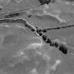
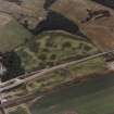
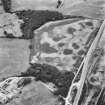
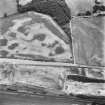
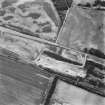
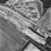
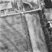
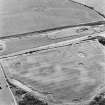
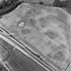
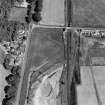
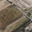
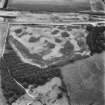
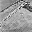
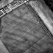
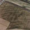
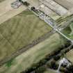
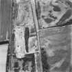
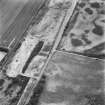
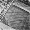
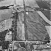
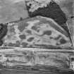
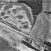
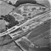
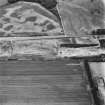
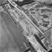
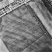
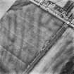
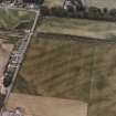
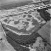
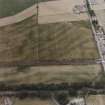
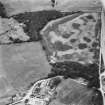
The Roman road is visible as quarry pits in RCAHMS oblique aerial photographs, immediately S of the Old Military Road.
Information from RCAHMS (SW), 23 July 2003.
Aerial Photographic Transcription (3 December 1992 - 10 December 1992)
An aerial transcription was produced from oblique aerial photographs. Information from Historic Environment Scotland (BM) 31 March 2017.
Aerial Photographic Transcription (10 September 1992 - 16 December 1992)
An aerial transcription was produced from oblique aerial photographs. Information from Historic Environment Scotland (BM) 31 March 2017.
Aerial Photographic Interpretation (9 December 2021)
Quarry pits flanking the Roman Road between Drumflower and Dunragit have been recorded as cropmarking on oblique aerial photographs (RCAHMSAP 1992). Situated on either side of the Old Military Road to the SE of Drumflower Cottage, the row of pits on the S side extends WNW and ESE for a distance of at least 295m. A fewer number of corresponding pits are visible on the N side of the road.
Further stretches of quarry pits have been recorded to the SE (NX15NE 70.01) and to the NW (NX15NW 75.02).
Information from HES Archaeological Survey (K. Millican) 9 December 2021
Aerial Photographic Transcription (10 December 2021)
An interpretative transcription, or mapping, of information on oblique aerial photographs was produced on 10 December 2021.
Note (4 March 2022)
The location, classification and period of this site have been reviewed.

