
Scheduled Maintenance
Please be advised that this website will undergo scheduled maintenance on the following dates: •
Tuesday 3rd December 11:00-15:00
During these times, some services may be temporarily unavailable. We apologise for any inconvenience this may cause.
Bridge Of Sark - Portpatrick Military Road


Military Road (18th Century)
Site Name Bridge Of Sark - Portpatrick Military Road
Classification Military Road (18th Century)
Alternative Name(s) Dumfries And Galloway Road
Canmore ID 142885
Site Number NX15NW 104
NGR NX 1300 5823
NGR Description From NX 1499 5753 to NX 1000 5975
Datum OSGB36 - NGR
Permalink http://canmore.org.uk/site/142885


- Council Dumfries And Galloway
- Parish Inch
- Former Region Dumfries And Galloway
- Former District Wigtown
- Former County Wigtownshire
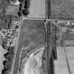
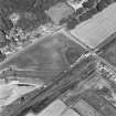
NX15NW 104.00 1499 5753 to 1000 5975. MR 23 (formerly Lin 518).
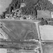
NX15NW 104.01 1396 5781 Bridge.
The military road appears to have been on the line now taken by the A75 as far as Castle Kennedy, where it takes a left fork S at NX 109 597.
W Taylor 1976.
The military road heads NW, passing to the S of Drumflower and to the N of Guinock (probably the modern Genoch). It then heads into Castle Kennedy.
G Taylor and A Skinner 1776.
Ballancollantie Bridge (NX15NW 104.01) at NX 1396 5781 is of two periods, the N half being the older, but a date is difficult to arrive at.
Visited by OS (EGC) 9 April 1968.
NX 1499 5753 to NX 1090 5976 modern road.
NX 1090 5753 to NX 1082 5973 no trace.
NX 1082 5973 to NX 1058 5968 modern road.
NX 1058 5968 to NX 1000 5975 metalled road (possibly carriage drive) meanders between two old banks c.12m to 13m apart.
Visited by OS (RD) 29 February 1968.
Aerial Photographic Transcription (10 December 2021)
An interpretative transcription, or mapping, of information on oblique aerial photographs was produced on 10 December 2021.

