
Scheduled Maintenance
Please be advised that this website will undergo scheduled maintenance on the following dates: •
Tuesday 3rd December 11:00-15:00
During these times, some services may be temporarily unavailable. We apologise for any inconvenience this may cause.
Dunragit


Archaeological Landscape (Prehistoric)
Site Name Dunragit
Classification Archaeological Landscape (Prehistoric)
Canmore ID 77650
Site Number NX15NE 69
NGR NX 15000 57300
NGR Description Centred NX 150 573
Datum OSGB36 - NGR
Permalink http://canmore.org.uk/site/77650


- Council Dumfries And Galloway
- Parish Old Luce
- Former Region Dumfries And Galloway
- Former District Wigtown
- Former County Wigtownshire
NX15NE 69.00 centred 150 573.
NX15NE 69.01 NX 1525 5722 Enclosure: pit-defined
NX15NE 69.02 NX 1512 5727 to 1525 5725 Pit-alignment
NX15NE 69.03 NX 1511 5727 Ring-ditch
NX15NE 69.04 NX 1519 5730 Ring-ditches (possible)
NX15NE 69.05 NX 150 574 Ring-ditches; Pits; Cropmarks
Also see NX15NE 70 Roman Road and NX15NW 76.00 Cropmark Complex
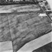
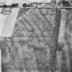
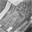
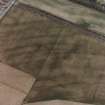
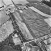
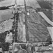
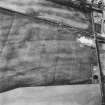
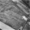
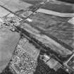
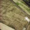
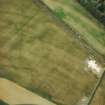
'...A complex of pit-defined enclosures, small ditched enclosures and pit-alignments of prehistoric date (situated S of Dunragit) represented by cropmarks visible on oblique aerial photographs.'
Information from Historic Scotland, February 1994.
Aerial Photographic Transcription (10 September 1992 - 16 December 1992)
An aerial transcription was produced from oblique aerial photographs. Information from Historic Environment Scotland (BM) 31 March 2017.
Note (11 April 2014)
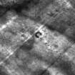
Excavation revealed the postholes of concentric timber enclosures, and as such the classification has been changed from pit enclosure to timber enclosure.
Information from RCAHMS (KMM) 11 April 2014

