
Pricing Change
New pricing for orders of material from this site will come into place shortly. Charges for supply of digital images, digitisation on demand, prints and licensing will be altered.
Ulston Moor


Temporary Camp (Roman)
Site Name Ulston Moor
Classification Temporary Camp (Roman)
Canmore ID 57053
Site Number NT62SE 41
NGR NT 6873 2165
NGR Description centred on 6873 2165
Datum OSGB36 - NGR
Permalink http://canmore.org.uk/site/57053


- Council Scottish Borders, The
- Parish Jedburgh
- Former Region Borders
- Former District Roxburgh
- Former County Roxburghshire
NT62SE 41 centred on 6873 2165.
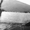
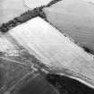
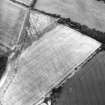
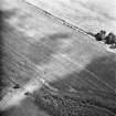
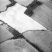
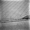
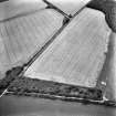
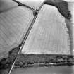
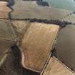
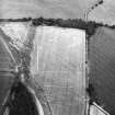
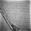
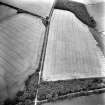
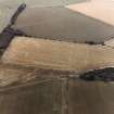
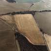
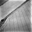
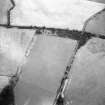
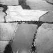
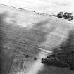
A large Roman temporary camp was identified by Dr St Joseph in 1955 close to the Roman Road, about 1/2 mile NW of Cappuck Fort (NT62SE 39).
The camp measures 750' SE-NW by approximately 1,125' Nearly the whole of the south and north sides, the north gate, and the west side with a central gate, have been located. The east side is thought to lie in the old plantation strip beside the road.
A ditch with a central gate crosses the camp 230' from its west front, and suggests that there have been two phases of occupation.
J K St Joseph 1955; 1958; 1961.
No traces are visible on the ground.
Visited by OS (WDJ) 18 January 1967.
Publication Account (17 December 2011)
First recorded in the 1950s by St Joseph from the air (1955: 81; 1958: 87; 1961: 121), the two-phase cropmark camp at Ulston Moor lies on the south-west side of Dere Street, opposite the camps of Millside Wood and a little way from the fort and camp at Cappuck. The two camps share part of at least two sides, with the north-east side unknown, but it may be located close to the road which sits on Dere Street. At least 324m, south-west to north-east, of the length of the larger camp (I) are known, and 253m transversely; the camp probably enclosed a little over 9ha (22 acres). Entrance gaps protected by tituli are visible in the north-west and south-east sides, with an entrance gap in the centre of the south-west. The reduced camp (II) has a length of at least 262m and probably enclosed around 7.5ha (over 18 acres). It appears to share the north-west and south-east entrance gaps with camp I, and a further entrance gap with titulus is visible in the centre of its south-west side.
R H Jones.
Sbc Note
Visibility: This site is visible as a cropmark.
Information from Scottish Borders Council

