
Pricing Change
New pricing for orders of material from this site will come into place shortly. Charges for supply of digital images, digitisation on demand, prints and licensing will be altered.
Drylawhill


Settlement(S) (Later Prehistoric)
Site Name Drylawhill
Classification Settlement(S) (Later Prehistoric)
Canmore ID 56226
Site Number NT57NE 27
NGR NT 59153 78044
NGR Description Centre
Datum OSGB36 - NGR
Permalink http://canmore.org.uk/site/56226


- Council East Lothian
- Parish Prestonkirk
- Former Region Lothian
- Former District East Lothian
- Former County East Lothian
NT57NE 27 NT 59156 78045
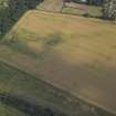
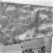
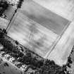
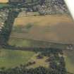
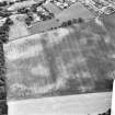
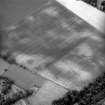
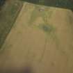
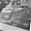
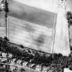
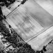
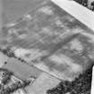
What are probably the superimposed remains of two distinct phases of enclosed settlement have been recorded as cropmarks on oblique aerial photographs (RCAHMSAP 1977, 1981, 1991, 1993) on the crest of a low hill to the W of Drylawhill farmsteading. The larger enclosure is roughly rectilinear on plan, measuring about 65m from ENE to WSW by 53m transversely within a ditch up to 4m in breadth. The second enclosure, which is oval lies in the interior and shares its long axis; it measures about 40m by 30m within a ditch about 5m in breadth. The relative sequence of the enclosures is not known.
Information from RCAHMS (DCC) 4 March 2005
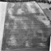
Aerial Photographic Transcription (12 August 1993)
An aerial transcription was produced from oblique aerial photographs. Information from Historic Environment Scotland (BM) 31 March 2017.
Desk Based Assessment (8 February 2002)
Headland Archaeology undertook an assessment of archaeological issues affecting a proposed area of development at Drylawhill, East Linton.
This 24 ha site on the north side of the village has been identified by East Lothian Council as a potential site for approximately 350 houses.
None of the archaeological features have been subject to field evaluation so the level of knowledge about specific features is low. However, the majority of the development site lies within the limits of a scheduled ancient monument and therefore the archaeological features are, de facto, of national importance.
Headland Archaeology 2002
Note (7 June 2023)
The location, classification and period of this site have been reviewed and changed from SETTLEMENT(S) (PERIOD UNASSIGNED).

