
Pricing Change
New pricing for orders of material from this site will come into place shortly. Charges for supply of digital images, digitisation on demand, prints and licensing will be altered.
Penchrise Pen


Enclosure (Prehistoric), Fort (Iron Age)
Site Name Penchrise Pen
Classification Enclosure (Prehistoric), Fort (Iron Age)
Canmore ID 54052
Site Number NT40NE 5
NGR NT 4907 0623
Datum OSGB36 - NGR
Permalink http://canmore.org.uk/site/54052


- Council Scottish Borders, The
- Parish Cavers
- Former Region Borders
- Former District Roxburgh
- Former County Roxburghshire
NT40NE 5 4907 0623.
(NT 4907 0623) Fort (NR)
OS 6" map (1958)
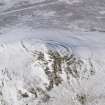
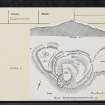
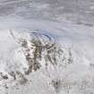
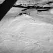
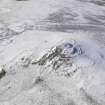
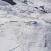
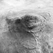
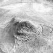
Fort and Enclosure, Penchrise Pen: The summit of Penchrise Pen (1438 ft OD) is an almost bare, flat-topped cone of rock, about 100 ft in height, with two natural shelves to NE. This area, measuring 345 ft from NE to SW by 270 ft transversely, is enclosed within the very much wasted remains of three ramparts with entrances in NW and NE; on the S the bare rock is too steep to support a rampart, and in the SE they are reduced to terraces.
A bank, 60 ft long by 25 ft broad, in the interior restricts access from the NW. On the shelf just above it, a low bank, 26 ft in diameter, may represent a hut circle. A low earthen bank borders the NW side of the upper terrace, and near its E end there is a crescentic depression.
A triangular annexe, measuring 220 ft by 130 ft, lies on a shelf immediately below and W of the cone. It is formed by a single earthen rampart and external quarry-ditch, now visible as a terrace, 10 ft broad. The entrance is in the N. Three hut circles, now visible as slight trenches, lie in the interior, where there is also a shallow scooped hollow about 12 ft in diameter.
An oval enclosure, bounded by the remains of a low, spread, earthen bank and measuring 225 ft by 165 ft, lies immediately NE of the fort, partly blocking its NE entrance. There are traces of a quarry-ditch, and an entrance, in the NE. The interior is featureless.
RCAHMS 1956, visited 1949
Resurveyed at 1:2500.
Visited by OS (WDJ) 7 April 1965
The fort and enclosure are as previously described.
Surveyed at 1:10,000.
Visited by OS (JRL) 13 December 1979
The fort and enclosure are visible on vertical air photographs (106G/Scot/UK 433, 4200-4201, flown 24 June 1945).
Information from RCAHMS (DE), March 2006
Note (3 August 2015 - 19 October 2016)
The conical summit of Penchrise Pen, which is a distinctive and prominent landmark in the locality, is crowned by a fort with up to three ramparts, the outer of which on the W is accompanied by an external ditch set at the foot of the slope. Oval on plan, the interior measures about 100m from NE to SW by 75m transversely (0.55ha) and on the NE rises in two broad shelves up to the summit. Apart from where they run up against a bare and craggy outcrop on the S, the defences have probably been continuous, the ramparts forming low banks in the N sector, though they have been reduced to scarps on the steeper slopes elsewhere. In addition to the ditch below the outermost rampart on the W, another short segment can be seen on the N, not only suggesting that this ditch may have been a more continuous feature, but that the stepped profile of the defences may also hide quarry ditches between the lines elsewhere. While the defences have probably formed a continuous circuit, the number of ramparts varies, the outer on the W dividing into two create a belt of three 20m deep flanking the SW side of the entrance on the NW; on opposite side there are only two, which extend round the relatively accessible N flank to a second entrance on the NE. At the latter the entrance-way approaches obliquely up the slope to expose the visitor's right side, and a terrace to the rear of the inner rampart continues up the slope to the lower shelf in the interior. The approach to the NW entrance is more direct, but again there is a clear route mounting the slope to the lower shelf, passing an isolated length of bank on the N side of the interior. Apart from this bank and traces of internal quarrying to the rear of the inner rampart, the only features visible within the interior are a low ring-bank on the lower terrace and a platform cut into the slope on the SE.
While it is not possible to identify any stratigraphic relationships between the ramparts, variations in the composition of the defences around the circuit may reflect several periods of construction and refurbishment. This is certainly the case with the two enclosures attached on the W and NE respectively, both of which ride over the outermost defences, that on the NE also impinging on the entrance way which climbs the slope obliquely on this side. The latter enclosure is oval on plan and measures about 65m from N to S by 49m transversely (0.24ha) within a bank that is accompanied on the NE by an external ditch; its entrance is on the NE. The enclosure on the W springs from the outer rampart on the WSW to cross the ditch at the foot of the slope and take in a triangular area measuring up to 63m from N to S by 45m transversely (0.22ha) within a thick bank accompanied by an external ditch; its entrance is on the NNW and traces of at least three ring-ditch houses can be seen in the interior.
Information from An Atlas of Hillforts of Great Britain and Ireland – 19 October 2016. Atlas of Hillforts SC3245
External Reference (20 July 2015)
The entry in the Schedule of Monuments relating to this monument was amended in 2015.
Information from Historic Scotland, 20th July 2015
Sbc Note
Visibility: This is an upstanding earthwork or monument.
Information from Scottish Borders Council

