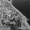
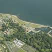
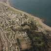
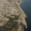
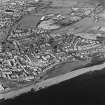
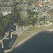
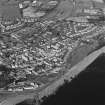
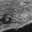
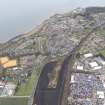
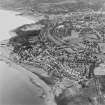
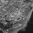
Accessibility

Font Size

100% 150% 200%

Background Colour

Default Contrast
Close Reset

Dysart, General

Burgh (Medieval), Village (Period Unassigned)

Site Name Dysart, General

Classification Burgh (Medieval), Village (Period Unassigned)

Canmore ID 76024

Site Number NT39SW 28

NGR NT 3000 9300

Datum OSGB36 - NGR

Permalink http://canmore.org.uk/site/76024
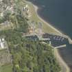
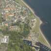
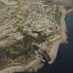
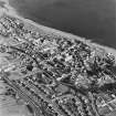
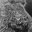
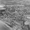
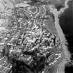
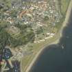
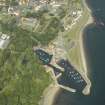
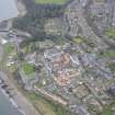
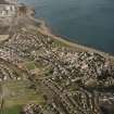
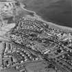
Ordnance Survey licence number AC0000807262. All rights reserved.
Canmore Disclaimer. © Bluesky International Limited 2025. Public Sector Viewing Terms

Toggle Aerial | View on large map

Digital Images

Oblique aerial view centred on the house, monastery and gardens with the church and burial ground adjacent, taken from the W.
Oblique aerial view centred on the house, monastery and gardens with the church and burial ground adjacent, taken from the W.Oblique aerial view centred on the harbour with the monastery, garden, church, churchyard and burial ground adjacent, taken from the W.Oblique aerial view centred on the house, monastery and gardens with the church, burial ground and harbour adjacent, taken from the WSW.Dysart & Harbour. Fife-shire.Oblique aerial view of Dysart centred on the village housing redevelopment designed by Wheeler and Sproson in 1958-71, and recorded as part of the Wheeler and Sproson Project and a Threatened Building Survey completed in 1997.  Taken from the SSW.Oblique aerial view of Dysart centred on the village housing redevelopment designed by Wheeler and Sproson in 1958-71, and recorded as part of the Wheeler and Sproson Project and a Threatened Building Survey completed in 1997.  Taken from the W.Oblique aerial view of Dysart centred on the village housing redevelopment designed by Wheeler and Sproson in 1958-71, and recorded as part of the Wheeler and Sproson Project and a Threatened Building Survey completed in 1997.  Taken from the SSW.Oblique aerial view of Dysart centred on the village housing redevelopment designed by Wheeler and Sproson in 1958-71, and recorded as part of the Wheeler and Sproson Project and a Threatened Building Survey completed in 1997.  Taken from the ENE.Oblique aerial view of Dysart centred on the village housing redevelopment designed by Wheeler and Sproson in 1958-71, and recorded as part of the Wheeler and Sproson Project and a Threatened Building Survey completed in 1997.  Taken from the W.Oblique aerial view centred on the house, monastery and gardens with the church, burial ground and harbour adjacent, taken from the SSW.General View Kirkcaldy and Dysart, Fife, Scotland. Oblique aerial photograph taken facing South. This image was marked by AeroPictorial Ltd for photo editing.Oblique aerial view of Dysart centred on the village housing redevelopment designed by Wheeler and Sproson in 1958-71, and recorded as part of the Wheeler and Sproson Project and a Threatened Building Survey completed in 1997.  Taken from the SW.General oblique aerial view centred on the harbour with the monastery, garden, church, churchyard and burial ground adjacent, taken from the W.Oblique aerial view of Dysart centred on the village housing redevelopment designed by Wheeler and Sproson in 1958-71, and recorded as part of the Wheeler and Sproson Project and a Threatened Building Survey completed in 1997.  Taken from the WSW.Oblique aerial view of Dysart centred on the village housing redevelopment designed by Wheeler and Sproson in 1958-71, and recorded as part of the Wheeler and Sproson Project and a Threatened Building Survey completed in 1997.  Taken from the SW.Oblique aerial view of Dysart centred on the village housing redevelopment designed by Wheeler and Sproson in 1958-71, and recorded as part of the Wheeler and Sproson Project and a Threatened Building Survey completed in 1997.  Taken from the ESE.Oblique aerial view centred on the harbour with the monastery, garden, church, churchyard and burial ground adjacent, taken from the SSE.Dysart redevelopment, Phase 1.
View showing two blocks of maisonettes.
Oblique aerial view of Dysart centred on the village housing redevelopment designed by Wheeler and Sproson in 1958-71, and recorded as part of the Wheeler and Sproson Project and a Threatened Building Survey completed in 1997.  Taken from the SSE.Oblique aerial view of Dysart centred on the village housing redevelopment designed by Wheeler and Sproson in 1958-71, and recorded as part of the Wheeler and Sproson Project and a Threatened Building Survey completed in 1997.  Taken from the SE.Oblique aerial view.Dysart Harbour.
Photographic copy of engraving. General view of harbour, including St Serf's Kirk, The Shore and ships. Insc: 'Dysart and Harbour. Fifeshire'View of entrance elevation of The Towers, Dysart, after reconstruction.Oblique aerial view centred on the harbour with the monastery, garden, church, churchyard and burial ground adjacent, taken from the SW.Oblique aerial view.Dysart, Howard Street.
View of Phase 2 blocks of flats.Oblique aerial view of Dysart centred on the village housing redevelopment designed by Wheeler and Sproson in 1958-71, and recorded as part of the Wheeler and Sproson Project and a Threatened Building Survey completed in 1997.  Taken from the W.Oblique aerial view of Dysart centred on the village housing redevelopment designed by Wheeler and Sproson in 1958-71, and recorded as part of the Wheeler and Sproson Project and a Threatened Building Survey completed in 1997.  Taken from the W.Oblique aerial view of Dysart centred on the village housing redevelopment designed by Wheeler and Sproson in 1958-71, and recorded as part of the Wheeler and Sproson Project and a Threatened Building Survey completed in 1997.  Taken from the NE.Oblique aerial view of Dysart centred on the village housing redevelopment designed by Wheeler and Sproson in 1958-71, and recorded as part of the Wheeler and Sproson Project and a Threatened Building Survey completed in 1997.  Taken from the S.

Administrative Areas

  • Council Fife
  • Parish Kirkcaldy And Dysart
  • Former Region Fife
  • Former District Kirkcaldy
  • Former County Fife

Archaeology Notes

NT39SW 28 3000 9300.

Dysart was a burgh of barony at least as early as 1510, it was re-erected burgh of barony in 1549, and this was still its status in 1699. However, it appeared in Parliament in 1593/4, from which date, at least, it must for practical purposes be counted as a royal burgh, for, despite many 16th- and 17th-century documents attesting its status as a burgh of barony, no objections appear to have been raised to its enjoyment of the priviliges of a royal burgh.

G S Pryde 1965.

Architecture Notes

REFERENCE:

EDINBURGH PUBLIC LIBRARY

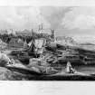
James Grant Sketch Book in MSS - 3 exteriors and details, 1851

Activities

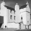
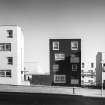
Photographic Survey (October 1964 - November 1964)

Photographic survey of buildings in Dysart by the Scottish National Buildings Record/Ministry of Work in October and November 1964.

References

MyCanmore Image Contributions


Contribute an Image

MyCanmore Text Contributions