
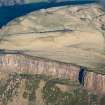
Edinburgh, Holyrood Park, Salisbury Crags


Rig And Furrow (Medieval) - (Post Medieval), Structure(S) (Period Unassigned)
Site Name Edinburgh, Holyrood Park, Salisbury Crags
Classification Rig And Furrow (Medieval) - (Post Medieval), Structure(S) (Period Unassigned)
Alternative Name(s) Salisbury Crags; Camstone Quarry; Queen's Park
Canmore ID 157261
Site Number NT27SE 3952
NGR NT 2694 7335
Datum OSGB36 - NGR
Permalink http://canmore.org.uk/site/157261


- Council Edinburgh, City Of
- Parish Edinburgh (Edinburgh, City Of)
- Former Region Lothian
- Former District City Of Edinburgh
- Former County Midlothian
Field Visit (15 December 1998)
NT27SE 3952 2694 7335
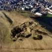
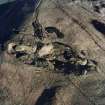
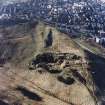
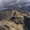
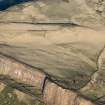
Two small subsquare structures lie some 80m apart in an area of rig-and-furrow cultivation between the lip of Salisbury Crags and Camstone Quarry (NT27SE 3943). Overall, the western structure measures 6.5m across, and the eastern 6.3m by 5.8m, and both are enclosed by an earthen bank 1.5m thick and 0.15m high. Although neither appear in association with the features of the rifle range (NT27SE 3950), they are probably of similar date. The rigs are barely perceptible on the ground, but are visible on oblique aerial photographs (C29941-3CN). They extend across an area that appears to have been scraped of topsoil, perhaps in preparation for an extension to the quarry. The structures and the rig-and-furrow are plotted at 1:5,550 on an archaeological map of Holyrood Park (RCAHMS 1999).
Visited by RCAHMS (ARG), 15 December 1998.
NMRS, MS/726/96 (67, no. 65); RCAHMS 1999.

