
Scheduled Maintenance
Please be advised that this website will undergo scheduled maintenance on the following dates: •
Tuesday 3rd December 11:00-15:00
During these times, some services may be temporarily unavailable. We apologise for any inconvenience this may cause.
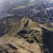
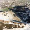
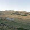
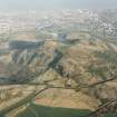
Edinburgh, Holyrood Park, Hunter's Bog, Rifle Range


Firing Range (First World War), Firing Range(S) (19th Century) - (20th Century)
Site Name Edinburgh, Holyrood Park, Hunter's Bog, Rifle Range
Classification Firing Range (First World War), Firing Range(S) (19th Century) - (20th Century)
Alternative Name(s) The Dasses; Camstone Quarry; Queen's Park
Canmore ID 157259
Site Number NT27SE 3950
NGR NT 2718 7321
NGR Description Centred NT 2718 7321
Datum OSGB36 - NGR
Permalink http://canmore.org.uk/site/157259


- Council Edinburgh, City Of
- Parish Edinburgh (Edinburgh, City Of)
- Former Region Lothian
- Former District City Of Edinburgh
- Former County Midlothian
NT27SE 3950 centred 2718 7321
See also NT27SE 3807 and NT27SE 3952.
A cultural heritage survey of Holyrood Park, Edinburgh, was undertaken in February 1996. The survey was designed to identify and evaluate the archaeological remains present withing Holyrood Park, through the examination of desk-based sources and a field inspection. A large number of sites were already recorded within the park and are listed in the NMRS. The following list is of sites not previously recorded (excluding rig and furrow and unassociated field banks), the majority of which relate to quarrying activities or are features associated with 19th-century use and management of the park.
NT 273 735 - NT 272 730 Rifle range.
NT 268 733 - NT 273 731 Rifle range.
A full report will be lodged with the NMRS.
Sponsor: Historic Scotland
D Alexander 1996.
Field Visit (15 December 1998)
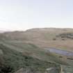
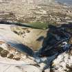
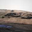
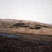
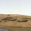
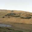
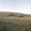
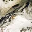
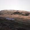
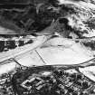
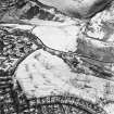
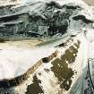
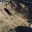
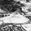
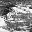
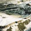
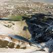
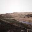
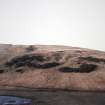
Hunter's Bog was used as a rifle range from at least the 1830s until the 1950s. The area was first used for target practice by the castle garrison, and during the late 1880s it was used by the volunteer brigades of the Royal Scots. The range continued in operation until at least 1953, when it was still serving the Territorial Army.
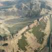
During this time, the range underwent several changes, many of which are charted graphically by the successive editions of the OS 25-inch maps. In 1877, there were eight firing lines running roughly from N to S along the valley floor, with the targets and mantlets situated at the S end. The firing positions were spaced at 50-yard intervals up to a maximum distance of 600 yards, and two magazines were in use, the first located in Camstone Quarry and the second at the N end of the lowermost of the Dasses. The positions of both magazines are now indicated by rectangular platforms, but little can be seen of the firing positions. Only one row of four, regularly-spaced stances is visible along the floor of Hunter's Bog, and the 600-yard firing position of the easternmost firing line is marked by an L-shaped revetment low down on the Dasses.
By 1896, the direction of the ranges had switched to firing across the valley. Two firing lines were in operation, with their targets located at the foot of Arthur's Seat to the E. The southern line had firing positions at intervals of 50 yards for ranges up to 300 yards, and the northern line, 120m to the N, had firing positions at 100-yard intervals from 400 yards up to 600 yards. The firing positions of the northern line survive as rectangular platforms, while, under low sunlight, those belonging to the southern line are visible as narrow flights of steps ascending the slope at the SW end of Hunter's Bog. The latter appear to have been out of use by 1908, replaced by firing positions located at 100 yard intervals in line with the northern range.
The continued use of the rifle ranges is charted on the four editions of the OS 25-inch map dated from 1896 to 1933, which depict the various modifications and additions that took place. The 400- and 500-yard firing positions were relocated a short distance to the S after 1896, while between 1908 and 1914, the 300-yard firing position was also relocated to the S and the targets extended. The magazine in Camstone Quarry remained in use throughout, although the magazine at the southern end of the Dasses was moved to the S after 1908; various other roofed buildings are also shown on the maps. The targets and associated buildings were dismantled in 1961; the firing positions and the locations of buildings are now indicated by low mounds and rectangular platforms or terraces, while the targets are visible as a narrow ledge at the SE end of Hunter's Bog. These features are plotted at 1:5,550 on an archaeological map of Holyrood Park (RCAHMS 1999).
Visited by RCAHMS (ARG), 15 December 1998.
NMRS, MS/726/96 (66-7, nos. 63-4); C Wickham-Jones 1996; RCAHMS 1999.
Project (March 2013 - September 2013)
A project to characterise the quantity and quality of the Scottish resource of known surviving remains of the First World War. Carried out in partnership between Historic Scotland and RCAHMS.

