
Scheduled Maintenance
Please be advised that this website will undergo scheduled maintenance on the following dates: •
Tuesday 3rd December 11:00-15:00
During these times, some services may be temporarily unavailable. We apologise for any inconvenience this may cause.
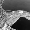
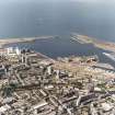
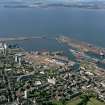
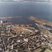
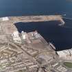
Edinburgh, Leith, Caledonia Flour Mills


Flour Mill(S) (20th Century)
Site Name Edinburgh, Leith, Caledonia Flour Mills
Classification Flour Mill(S) (20th Century)
Alternative Name(s) Chancelot Mills; Church Street; Quayside Mills; Leith Docks; Western Harbour
Canmore ID 69990
Site Number NT27NE 117
NGR NT 26016 77051
NGR Description Centred NT 26016 77051
Datum OSGB36 - NGR
Permalink http://canmore.org.uk/site/69990


- Council Edinburgh, City Of
- Parish Edinburgh (Edinburgh, City Of)
- Former Region Lothian
- Former District City Of Edinburgh
- Former County Midlothian
NT27NE 117 centred 26016 77051
Mills [NAT]
OS 1:10,000 map, 1985.
Chancelot Mill [NAT] (at NT 2598 7705)
OS (GIS) AIB, June 2006.
Location formerly entered as NT 261 771.
See also NT27NE 57.00 and NT27NE 57.10 .
NMRS Print Room:
W Schomberg Scott Photograph Collection, Acc no 1997/39
2 views (one of them duplicated)
Church Street, Quayside Mills
NMRS REFERENCE:
Dick Peddie & MacKay, Edinburgh adds & alts
Attic 2, Bin 10, Bag 1 J R MacKay 1937
(Undated) information in NMRS.
A modern complex still in use as a flour mill and store.
Site recorded by GUARD during the Coastal Assessment Survey for Historic Scotland, 'The Firth of Forth from Dunbar to the Coast of Fife' 23rd February 1996.
Standing Building Recording (2013)
NT 26016 77051: At the behest of the City of Edinburgh Council Archaeology Service (CECAS), a curving revetting wall for Lyndsay Road to the south of Chancelot/ ADM Mill was recorded by digital photography
and written description. The wall was 13.1 m long 2.45 m high and comprised nine courses of irregular stones capped by concrete that supported iron railings. Additional supports for the railings have been attached to the face of the wall. A drain pipe also protrudes from the upper
section of the wall and may be an overflow drain from the road surface above. The building stone was a mixture of shaped rectangular blocks and natural rounded boulders, some of which had been split and roughly shaped. The wall appears to have collapsed in places as there are
two areas that have been repaired. The repaired sections consist of smaller stones laid in regular courses but still included natural rounded boulders.
Information from Christine Rennie and Bob Will (GUARD Archaeology) 20 February 2013. OASIS ID: guardarc1-171032

