
Pricing Change
New pricing for orders of material from this site will come into place shortly. Charges for supply of digital images, digitisation on demand, prints and licensing will be altered.
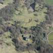
Mavisbank House


Earthwork (Medieval)(Possible), Earthwork (Prehistoric)(Possible), Garden Feature (18th Century)
Site Name Mavisbank House
Classification Earthwork (Medieval)(Possible), Earthwork (Prehistoric)(Possible), Garden Feature (18th Century)
Alternative Name(s) Bilston Burn; River North Esk; Mavisbank House Policies; New Saughton Hall
Canmore ID 51714
Site Number NT26NE 43
NGR NT 2872 6506
Datum OSGB36 - NGR
Permalink http://canmore.org.uk/site/51714


- Council Midlothian
- Parish Lasswade
- Former Region Lothian
- Former District Midlothian
- Former County Midlothian
NT26NE 43 2872 6506.
NT26NE 54.00 28807 65146 Mavisbank House
(NT 2872 6506) Earthwork (NR)
OS 1:10000 map (1974)
The RCAHMS describe a fort occupying the level summit of a knoll in the angle formed by the junction of the Bilston Burn with the River North Esk. No trace of a wall or rampart surrounding the enceinte is left, and the only artificial work remaining is the scarping and a terrace 12' broad which runs round the fort except for a short distance on the W arc. On the NW the scarp above the terrace is 12' high, and the scarp below falls 10', while on the E the corresponding measurements are 8' and 7'. The summit area measures 156' N-S by 153'. "Several articles of brass" (OSA 1794), noted as "weapons, bridle bits, surgical instruments, styli, fibulae etc" (NSA 1845) which were to be seen at Penicuik House in 1845, were found here in the 18th c.
RCAHMS 1929, visited 1913
Situated on a high promontory is this circular, level-topped plateau, 50.0m in diameter and comprising two scarped slopes with a small terrace 3.0m - 4.0m broad, between. The maximum height of the upper scarp is 4.0m, and of the lower, 2.0m. No trace of any walling or ramparts was found. On the NE, a short road leads up to the terrace and may be contemporary with the earthwork.
Visited by OS (JLD) 1 September 1954
This earthwork is as described in the previous field report. Its purpose is not clear but it seems unlikely to be the remains of an Iron Age work. More probably it is a terraced motte but as it lies in the open parkland of the early 18th c New Saughton Hall (formerly known as Mavisbank House) the possibility of it being an ornamental work should not be discounted.
Visited by OS (JP) 17 December 1975
Field Visit (13 August 1913)
Fort, Mavisbank House.
Situated in the grounds of Mavisbank House, this fort occupies the levelled summit of a knoll in the angle formed by the junction of the Bilston Burn with the river North Esk, about 100 yards southwest of Mavisbank House, at an elevation of 350 feet above sea-level and 100 feet above the North Esk, which flows about 250 yards distant. To the west, across a slight hollow, the ground rises with a steep slope, but elsewhere, from a distance of 50 feet from the steeply scarped sides of the fort, the descent to the low ground on the left bank of the two streams is very sharp. No trace of a wall or rampart surrounding the enceinte is left, and the only artificial work remaining is the scarping and a terrace 12 feet broad, which runs round the fort, except for a short distance on the western arc. On the north-west the scarp above the terrace rises 12 feet in height and the scarp below falls 10 feet, while on the east the corresponding measurements are 8 feet and 7 feet. The enceinte is almost circular, but measures slightly more from east to west than from north to south, the dimensions being 156 feet and153 feet respectively.
‘Several articles of brass, and of ancient form’ were found here in the 18th century (1). This led Sir John Clerk to conclude that the fort had been ‘a Roman station’. Despite the fact that there is nothing in its appearance to suggest a Roman origin, General Roy accepted Clerk's view, and based upon it the erroneous theory as to the course of the Roman road, which is referred to in the Introduction (p. xxix).
RCAHMS 1929, visited 13 August 1913.
(1) Stat. Acct., x, p. 287.
OS map: iii S.W.
Note (1988)
Mavisbank House NT 2872 6506 NT26NE 43
At the junction of the Bilston Burn and the River North Esk about 100m SW of Mavisbank House, there is a steep-sided knoll up to 6m high, surrounded on all sides but the W by a terrace from 3m to 4m in breadth. The flat summit of the knoll measures about 50m in diameter. According to the Statistical Account this knoll was a fort, whose ramparts had been modified to form the terrace, presumably as a garden feature. Some 'articles of brass', then in the Clerk of Penicuik collection, were said to have been found at the site, including weapons, bridle bits, surgical instruments, styli and fibulae. Amongst the items from the Clerk collection that are now in the Royal Museum of Scotland, there are some surgical instruments (FT 77-85), but these are said to have come from Cramond (see also NT25NW 14).
RCAHMS 1988
(Stat. Acct., x, 1794, 286-7; NSA, I, Edinburgh, 333; Macdonald 1897, 246; PSAS, liv, 1919-20f, 149)
Note (4 November 2015 - 1 June 2016)
This earthwork, which occupies a steep-sided hillock overlooking the ruin of Mavisbank House from the SW, was probably adapted as a mount within the policies of Mavisbank House, which was built 1724-39 by the well-known Scottish antiquary Sir John Clerk of Penicuik. The modification of the ramparts to create the terrace visible halfway down the flanks of the hillock, seems to have led to the discovery of various items, supposedly including weapons, bridle bits, surgical instruments, styli and fibulae (Stat Acct, x, 1794, 286-7), though this eclectic collection, noted long after the discovery, sounds more like the contents of a display cabinet where they were kept in in Penicuik House. While the mound has taken on the appearance of a motte, measuring 47m across its summit, this may have more to do with the creation of a mount within the policies rather than the original form of the earthworks, and with a plethora of small circular forts and settlements now known along the Lothian Plain, there is a possibility that it was another example of one of these exploiting a strong position on the edge of Bilston Glen.
Information from An Atlas of Hillforts of Great Britain and Ireland – 01 June 2016. Atlas of Hillforts SC3703

