Pricing Change
New pricing for orders of material from this site will come into place shortly. Charges for supply of digital images, digitisation on demand, prints and licensing will be altered.
Upcoming Maintenance
Please be advised that this website will undergo scheduled maintenance on the following dates:
Thursday, 9 January: 11:00 AM - 3:00 PM
Thursday, 23 January: 11:00 AM - 3:00 PM
Thursday, 30 January: 11:00 AM - 3:00 PM
During these times, some functionality such as image purchasing may be temporarily unavailable. We apologise for any inconvenience this may cause.
Black Meldon
Fort (Prehistoric), Ring Groove House(S) (Prehistoric)
Site Name Black Meldon
Classification Fort (Prehistoric), Ring Groove House(S) (Prehistoric)
Canmore ID 51547
Site Number NT24SW 3
NGR NT 2063 4251
Datum OSGB36 - NGR
Permalink http://canmore.org.uk/site/51547
- Council Scottish Borders, The
- Parish Lyne
- Former Region Borders
- Former District Tweeddale
- Former County Peebles-shire
NT24SW 3 2063 4251.
(NT 2063 4251) Fort (NR)
OS 6" map (1965)
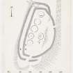
This fort occupies a rocky knoll which crowns the summit of Black Meldon. The site is easily approached from the W up a very gentle slope, but on all other sides the steep fall of the ground provides strong natural protection.
The fort measures 240' by 130' within a stone wall (A) which is now reduced to a band of debris, 10' thick, in which only one facing stone is visible. On the N, S and W there is an outer wall (B), now represented by only the debris of the core. The main entrance is situated at the SSW end of the fort and runs obliquely through both walls, while a gap on the NE side of wall A may mark the position of a subsidiary entrance. The interior of the fort contains the surface traces of at least seven ring groove houses, the largest measuring 36' and the smallest 28' in diameter.
At the time of visit, the vegetation had recently been burned off the surface of the SW part of the interior, exposing traces of stone hearths at the centres of two of the houses.
(Information from R W Feachem notebook 1951-4, 86)
RCAHMS 1967, visited 1959
This fort is generally as described. Three of the house-platforms are quite distinct; the other four are barely traceable.
Visited by OS (JLD) 2 May 1962 and (BS) 24 September 1974
Photographed by the RCAHMS in 1980.
(Undated) information in NMRS.
(Imagery formerly identified as enclosure and possible hut-circle at NT 201 424: originally numbered NT24SW 93). Comparison of the topographical and archaeological features visible on these photographs (RCAHMSAP 1991) with those on NT24SW 3 and NT24SW 72 shows that these photographs are of the fort on the summit of the Black Meldon (NT24SW 3), and not of an enclosure occupying the spur to the W. The combination of black-and-white photography and the snow cover is very deceptive, and obscures the stonework of the fort's wall.
Information from RCAHMS (SH), 18 January 1999.
NMRS, B47048-53 and B52084-8/CS.
Reference (1957)
This site is noted in the ‘List of monuments discovered during the survey of marginal land (1951-5)’ (RCAHMS 1957, xiv-xviii).
Information from RCAHMS (GFG), 24 October 2012.
Note (21 October 2015 - 16 August 2016)
This fort is situated on the rocky summit of the black Meldon, which forms the W bulwark of the Meldon valley. Roughly oval on plan, with a flattened WNW side, it measures 73m from NNE to SSW by 40m transversely (0.23ha) within a stone rampart reduced to a band of rubble some 3m thick. An outer rampart, again represented by a band of rubble, apparently springs from the inner on the NNE to extend round the WNW flank and SSE end before finally petering out on the margin of the summit area on the S. Both ramparts at this end of the fort are pierced by an entrance in which the gaps are staggered to create an oblique approach that exposes the visitor's left side; a second entrance lies on the ENE in a sector defended only by the inner rampart. Within the interior, traces of no fewer than seven round-house stances can be seen, five of them forming a row immediately to the rear of the rampart on the WNW side; the other two appear to be part of a second row along the ESE margin of the summit area, leading to the idea that the interior has been laid out around an axial street. The round house are defined by shallow grooves and three encircle slight platforms, while in two others RCAHMS investigators in 1959 observed what they believed to be settings of stones marking central hearths.
Information from An Atlas of Hillforts of Great Britain and Ireland – 16 August 2016. Atlas of Hillforts SC3673
Sbc Note
Visibility: This is an upstanding earthwork or monument.
Information from Scottish Borders Council


