
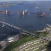
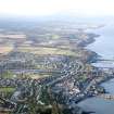
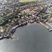
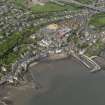
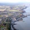
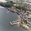
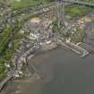
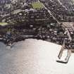
South Queensferry Harbour


Harbour (19th Century), Harbour (16th Century)
Site Name South Queensferry Harbour
Classification Harbour (19th Century), Harbour (16th Century)
Alternative Name(s) South Queensferry, Fishermen's Walk, Harbour; Inner Forth Estuary; Upper Firth Of Forth; Queensferry Narrows
Canmore ID 50615
Site Number NT17NW 71
NGR NT 13017 78545
Datum OSGB36 - NGR
Permalink http://canmore.org.uk/site/50615


- Council Edinburgh, City Of
- Parish Dalmeny
- Former Region Lothian
- Former District City Of Edinburgh
- Former County West Lothian
NT17NW 71.00 13017 78545
NT17NW 71.01 NT 1301 7851 Crane
NT17NW 71.02 NT 13021 78510 to NT c. 12968 78424 Ferry Pier (Slipway)
Not to be confused with South Queensferry, Hawes Pier (NT17NW 172.00 13633 78497), for which see NT17NW 172.00.
For corresponding harbour at North Queensferry (centred NT 129 803), see NT18SW 98.00.
Harbour [NAT]
OS 1:10,000 map, 1984.
19th Century improvements were carried out by R Stevenson (Engineer).
(Undated) information in NMRS.
(Location cited as NT 130 874). South Queensferry, West Lothian. Queensferry has a long history as a port, as it served as the S terminal of the Passagium Reginae, Queen Margaret's Ferry, all through the Middle Ages. It was then, like its counterpart (NT18SW 98.00) on the N, the property of Dunfermline Abbey (NT08NE 1.00), to which the ferry had been given by David I about 1150. Such extensive alterations, however, were made at the end of the 18th and beginning of the 19th centuries, that no structural features survive form early days in any identifiable form, and consequently the evolution of the harbour may be traced only from records, in so far as it is traceable at all.
The town (NT17NW 175) became a Royal Burgh in 1641, and was then described as having a 'haevine and herberie'. By about 1693 this seems to have taken the form of a pair of piers, as some work was done at that time on an eastern pier. The harbours (in the plural) were then said to be ruinous. In 1710 there was a 'Peer for Barks and Boats', and another, for boats of the Passage ferry, at Newhalls (the Hawes Inn) [NT17NW 112]. Roy's Map of Scotland (1747-55) marks a pair of piers almost comparable with those of today, but the E one is shown as longer than the W one and there is no transverse work across the N end of the harbour. Roy also places a small spot just N of this open N end, and this is shown, by an engraving of 1784, to have been an isolated block of masonry construction. In 1763, the harbour was 'in great measure demolished' by a storm, just when the Burgh was 'employed' in carrying forward a second quay, which was judged to be absolutely necessary to make the harbour compleat', the work in question probably having been an elongation of the W pier. In the 1780's the E pier was dangerous, and was threatening to the Passage jety which ran along its E side: work was accordingly begun with the object of extending the pier and turning its end westwards, as a precaution against north-easterly seas, but in 1789 a storm wrecked the new construction and also breached the W pier. This disaster seems to have necessitated a change of plan, as in 1791 the point of the E pier was lengthened, and in 1792 it was decided to take down and rebuilds the 'West Head of the Harbour without any gap or opening'. This may or may not have been done, as in 1795 a further decision was taken to rebuild the W pier. For the next twenty years no major works are recorded, but by 1815 the harbour had become unsafe, and an ambitious scheme was finding favour, namely to builds a breakwater westwards from the Sealscraig rocks [The Craigs: NT 1322 7338] and to enclose the whole of the bay. This, however, proved too costly, and in 1817 it was decoded, on the advice of an engineer named Hugh Baird, to turn the W pier at right angle and run it eastward, to make the entrance in the NE corner, and to rebuild the head of the E pier. Another entrance, presumably one at the NW corner, was closed, and the harbour thus seems to have been brought more or less to its present form.
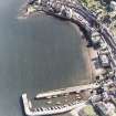
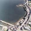
The structures resulting from these vicissitudes, and from later repairs, consist of an E pier, 340ft [103.7m] long, with the disused Passage jetty on its E side, and a W pier, 350ft [106.7m] long, which returns eastwards for 135ft [41.2m] (internally) to close the N end of the harbour, leaving an entrance 50ft [15.2m] wide at the NE corner. At the S end, there is a narrow beach, behind which rises a masonry revetment topped by the parapet of an elevated open space known as the Fishermen's Walk. The harbour extends to about four-fifths of an acre [0.3ha], and dries out at low water.
The build of the piers varies from place to place, but these variations cannot be correlated positively with works mentioned above. The following points, however, are worth recording. The E pier shows a face of rather large drystone blocks, squared but irregularly set, its end being rougher and mortared. The W pier, on its outer side, shows at least three different builds, having large blocks in its landward portion, then shorter squarish ones, and outside these longer and thinner slabs. The cross-pier at the N end is comparable with this last section, which would suggest that they both originated in the operations of 1817. Minor features are mooring-rings, a parapet-coping keyed with rectangular plugs, and pawls of whinstone and granite. On the cross-pier, the OS map of 1856 marks a 'Boiler', which recalls the boiling-houses at Bo'ness [Bo'ness Harbour: NS98SE 113] used by the Greenland whalers and a similar installation at Dysart Dysart, New Harbour: NT39SW 21]. Associated with the harbour are a well-paved ramp, with traces of a marginal iron strap, leading down to the beach on the E, the revetment-wall of the ground behind to E and W, with its droved and channelled masonry and string-course above, and the corbelled look-out at the corner of the Fishermen's Walk.
A Graham 1971.
(Location cited as NT 120 788). Harbour, [South] Queensferry, built c. 1812, engineer John Rennie. A narrow rectangular basin formed by an L plan and a straight pier, both rubble built.
J R Hume 1976.
This 16th century harbour was improved between 1809 and 1818. It is still in use and is in good condition.
Site recorded by GUARD during the Coastal Assessment Survey for Historic Scotland, 'The Firth of Forth from Dunbar to the Coast of Fife' 18th February 1996.
This tidal harbour remains in use by recreational sailing vessels.
Information from RCAHMS (RJCM), 15 May 2006.
Standing Building Recording (30 June 2022)
NT 12987 78500 A historic building record was carried out on
30 June 2022, prior to planned repair works at Queensferry Harbour (Canmore ID: 50615).
Queensferry Harbour in its current form is a fine example of early 19th-century civic engineering. It originally served as a commercial and fishing p ort, as well as a resupply point for the Royal Navy, and has lately been used as a base for the mooring of private boats. The harbour in its current layout is little different f rom t he o ne completed in the early 19th century and, whilst the main structure of the harbour’s piers remains relatively unchanged, alterations have clearly taken place including the improvement of the surfaces and parapets.
Archive: NRHE (intended) Funder: Private individual
Robert Usher – AOC Archaeology Group
(Source: DES Volume 23)

