
Pricing Change
New pricing for orders of material from this site will come into place shortly. Charges for supply of digital images, digitisation on demand, prints and licensing will be altered.
Tormain Hill 1


Cup And Ring Marked Rock (Neolithic) - (Bronze Age)
Site Name Tormain Hill 1
Classification Cup And Ring Marked Rock (Neolithic) - (Bronze Age)
Alternative Name(s) Bonnington Mains
Canmore ID 50365
Site Number NT16NW 7
NGR NT 12907 69667
NGR Description Centred NT 1290 6967
Datum OSGB36 - NGR
Permalink http://canmore.org.uk/site/50365


- Council Edinburgh, City Of
- Parish Ratho
- Former Region Lothian
- Former District City Of Edinburgh
- Former County Midlothian
NT16NW 7 centred 1290 6967.
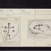
(Centred NT 1290 6967) Cup & Ring marked Rocks (NR) (7 shown)
OS 25" map (1969)
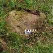
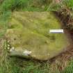
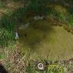
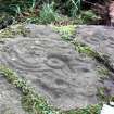
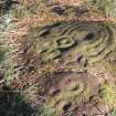
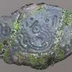
Several cup-and-ring markings have been found on outcropping rock surface on the highest point of Tormain Hill. They occur on eight outcrops in one area measuring c.15 yds by 7yds.
The markings include plain cups, cups with rings, concentric circles and gutters. (Outcrops A, C, D and E on plan; outcrop B, 4' x 2'3" bears a single cup. Outcrops F and G also have single cup-marks, and there are two cups on H.
R W Feachem 1963; RCAHMS 1929, visited 1927; J R Allen 1882; R W B Morris 1969
These rock outcrops are generally as described and illustrated, but "C" could not be found.
Surveyed at 1/2500.
Visited by OS (JTT) 19 August 1965
An interesting feature is that one of the cups on Stone 'D' has been utilised as a triangulation reference point by the Ordnance Survey in about 1853.
J L Davidson 1979
Publication Account (1985)
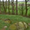
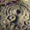
Tormain Hill affords fine views of the Pentlands, west Edinburgh, the Forth Road Bridge and the West Lothian landscape, with the Ochils beyond. The low summit ridge, at about 140m, shows a number of natural rocky outcrops; at least eight of these, within an area some 12m by 6m on the highest part of the ridge, bear a rich collection of man-made markings. Four or five sets of markings are clearly visible, especially with a late afternoon sun; the rest are overgrown with turf.
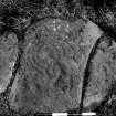
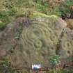
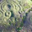
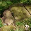
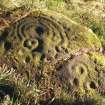
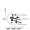
The markings vary from a single large cup on one rock, to a set of circles, concentric rings and grooves-as well as cup-marks-on another at the southern end of the group. This particular boulder, though split and rather worn, shows traces of 20 cups varying from 1.3cm to 5cm in diameter; at least seven cups are surrounded by single rings and in two instances the rings are connected by shallow grooves to simple cupmarks. The largest cup on this stone is circled by one complete ring, with three additional concentric arcs linking up four of the other rings.
Such markings were made, in the main, with small picks or driven punches-and a tedious, lengthy task it undoubtedly was. As a form of ornamentation they feature on fixed natural outcrops such as Tormain Hill (was it a special place of meeting or ceremony?), on smaller more 'portable' slabs, on standing stones, on or within burial cists. They may be clustered, several of one or various designs together; or singly. Outside Glencorse Parish Church, for instance (NT 246626), the upper surface of a slab of stone, less than 1m long, is covered with at least 22 cups, some with faint rings, and five cup-and-ring markings with radial or connecting grooves.
Information from 'Exploring Scotland's Heritage: Lothian and Borders', (1985).
Field Visit (6 April 2014 - 6 April 2014)
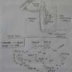
Seven rocks with prehistoric carvings were recorded on Tormain Hill by members of the Edinburgh Archaeological Field Society (EAFS) on 6 April 2014 in overcast and windy conditions. The seven carved rocks were originally documented by Sir James Simpson in 1867, and drawn by Romilly Allen in 1882. The EAFS retained Romilly Allen’s nomenclature (A-H) for recording the seven carved rocks on Tormain Hill. The area is a Scheduled Ancient Monument (Index No. 1161).
Location notes
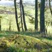
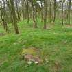
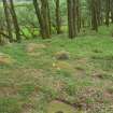
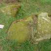
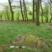
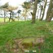
Seven prehistoric carved rocks (hereafter referred to as Tormain A-H) are located within an area of roughly 10m x 5m on the summit and gently sloping southern side of a distinct knoll situated towards the south end of a low, prominent ridge of whinstone, known as Tormain Hill, approximately 1.5 miles to the south west of Ratho.
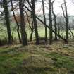
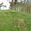
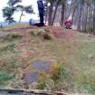
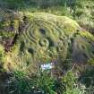
The ridge, which rises to a maximum altitude of 156m asl at the summit of the knoll, offers extensive views in all directions. The ridge is under mature open woodland, comprising a mixture of deciduous and evergreen trees with grass cover below. The area is in private ownership but has access via a well-used public footpath running from the southern outskirts of Ratho along the length of the ridge. A sign for ‘Cup and ring marked stones’ is situated approximately 20 m N of the carvings.
No prehistoric features were indentified on the ridge, although quern stones of unknown antiquity were found on the ridge to the south of the carvings in the late 19th century (Canmore ID 50323), and a felstone axehead of probable Neolithic date was discovered in the surrounding area in 1873 (Canmore ID 50322). A large cup-marked rock (the ‘Witches Stone’) was located approximately 200m in a field to the north west of Tormain Hill, but was blown up in 1919. Stone material from field clearance forms a field boundary running along the north western edge of Tormain, and this may contain fragments of the Witches Stone. The eastern edge of the knoll shows signs of quarrying activities, probably dating to the 18th or 19th centuries, which may have had an impact on some of the carved rocks, particularly Tormain A and E.
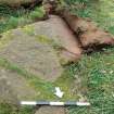
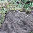
The knoll is comprised of outcropping coarse-grained igneous whinstone bedrock and loose boulders. The carvings are located on bedrock at ground level and on boulders or outcropping bedrock above ground level. The carvings and panels are in relatively good condition, although some panels show evidence of more recent human impact, including an Ordnance Survey benchmark carved on Tormain D in the 19th century. Turf is encroaching on some of the carvings, especially Tormain C which is at ground level. The relatively moist environment created by the tree canopy encourages the growth of moss and algae, while leaf litter, including pine needles, accumulates on the rock surface. The land is not currently stock-grazed but there is evidence of rabbit and badger activity.
Tormain A
NT 12908 69666
This roughly oval outcrop panel is located to the S of the knoll summit, on the S edge of the area in which the carvings are situated, 1.5m W of Tormain B and 2.7m S of Tormain G. The panel, which is orientated to the SE with an incline of 20 o, measures 1.30 x 0.78m and has a maximum height of 0.26m above ground level. There is significant algal growth on the panel surface and carved area, and the SE edge may have been affected by quarrying. Two natural fissures, running E-W, divide the panel into three. There are cup and ring carvings on the central and S segments of the panel. The carvings on the central segment comprise a central cup mark with a diameter of 7.0cm and depth of 1.0cm. Around this are four incomplete rings, the outer two of which end in circular motifs each with a central cup mark. Between these motifs and below the central cup mark is a raise cup with a single ring and slight groove. There are four further cups with diameters of 2.0-3.0cm and depths of 0.5-1.0cm and a short groove approximately 12.0cm long and 4.0cm wide on the N edge of this segment. The S segment of the panel has four cup marks of 2.5-3.0cm diameter and 0.4-0.8cm depth, two of which have a single ring. An arched groove runs across the S edge of the segment. A narrow incision, possibly a later addition, runs NW-SE along the S edge of the S segment.
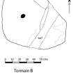
Tormain B
NT 12906 69665
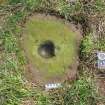
This roughly oval bedrock panel is located to the S of the knoll summit, 1.50m S of Tormain C and 1.20m W of Tormain G. The panel, which is orientated S with an incline of 5-10o, measures 0.80 x 0.80m and is 0.25 above ground level at its highest point. A turf-filled fissure with a maximum width of 0.20m bisects the panel in a N-S direction, with other narrow fissures on the W panel surface. There is significant algal growth on the panel and carved area, and moss encroaching on the E edges of the panel. A single cup mark is located approximately in the centre of the W portion of the panel. The cup mark is 4.0cm diameter and 1.0cm depth.
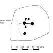
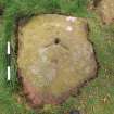
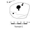
Tormain C
NT 12906 69668
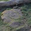
The panel comprises an outcrop of sub-rectangular shape located on the S edge of the knoll summit, 1.50m N of Tormain B. The panel, which is orientated W with an incline of 25 o, measures 0.60 x 0.42m and is at ground level. There is significant algal growth on the panel and carved area, and leaf litter accumulating on the carved area, with turf encroaching around the panel edges. Shallow fissures run in a NE-SW direction on the W side of the panel. There are five cup marks on the panel. Four of these are shallow, measuring 2.0-3.0cm in diameter and 0.5-1.0cm depth. A larger cup mark, located towards the E side of the panel, measures 16cm diameter and 4.0cm depth.
Tormain D
NT 12908 69673
This sub-rectangular bedrock panel is located on the N edge of the knoll summit, 4.75m NW of Tormain E and 5.10m NNE of Tormain C, at the N extremity of the area in which the carvings are located. The panel, which is orientated N with an incline of 20 o, measures 0.70 x 0.57m and has a maximum height of 0.19m above ground level. There is significant algal growth on the panel surface and carved area. There are four cup marks, the smallest of which measures 2.5cm diameter and 0.5cm depth and the largest of which measures 5.5cm diameter and 2.9cm depth. This larger cup mark has been enhanced and forms the point of an Ordnance Survey benchmark arrow motif. Another cup mark, measuring 5.5cm diameter and 1.2cm depth has been incorporated into the opposite end of the arrow motif but does not appear to have been enhanced. Each end of the two shorter arms of the arrow has a shallow depression, probably contemporary with the benchmark, and a small, cylindrical depression, possibly also contemporary with the benchmark, has been created approximately 7.5cm to the S of the arrow point.
Tormain E
NT 12909 69670
This sub-rectangular bedrock panel is located on the E side of the knoll summit, 3.3m N of Tormain H and 3.75m E of Tormain C. The panel surface is approximately horizontal but juts out from the steeply sloping quarried edge of the knoll. It measures 0.55 x 0.43m and has a maximum height of 0.50m above ground level on the E side. The S and E edges show signs of quarrying, and a number of the carvings have probably been enhanced or added in historical times. There is significant algal growth on the panel surface and carved area. There are nine cup marks measuring between 2.0 and 6.0cm diameter and 0.5 and 2.0cm depth. The two south easterly-most cup marks are irregular and are either later additions or have been modified. There are four grooves, three of which run from cup marks to the W edge of the panel. The two shorter of these grooves are narrow and sharp-edged, suggesting that they are more recent additions. The last few cm of the longest groove also has sharp edges and may have been modified. A further short groove, running from the long groove to a cup mark on the N side of the panel, has been modified by pecking. A shallow depression between the long groove and a cup mark on the S side of the panel may also be a later modification.
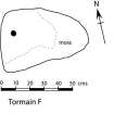
Tormain F
NT 12908 69669
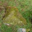
This sub-triangular boulder is located to the S of the knoll summit, 1.7m E of Tormain C and 0.9m N of Tormain H. The panel surface, which is approximately horizontal, measures 0.62 x 0.37m and has a maximum height of 0.18m above ground level. There is moss cover on the E edge of the boulder. There is one cup mark located towards the N edge of the panel, measuring 3.0cm diameter and 0.5cm depth.
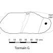
Tormain G
NT 12910 69666
This sub-rectangular boulder is located to the S of the knoll summit, 1.3m E of Tormain B, 2.7m N of Tormain A and 0.6m S of Tormain F. The panel, which is orientated to the S with an incline of 20 o, measures 1.01 x 0.36m and has a maximum height of 0.39m. The panel surface is slightly rounded and segmented by two fissures running approximately NE-SW, the most northerly of which is turf-filled and has a maximum width of 6.0cm. A single cup mark, measuring 3.0cm diameter and 0.5cm depth, is located on a raised area on the SE segment of the panel.
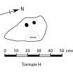
Tormain H
NT 12911 69665
This sub-triangular boulder is located to the S of the knoll summit 1.0m E of Tormain G and 2.2m NE of Tormain A. The panel, which is orientated E with an incline of 15 o, measures 0.36 x 0.26m and has a maximum height of 0.08m above ground level. The panel is being encroached by turf and moss. There are two cup marks towards the N edge of the panel measuring 3.0cm diameter and 0.8cm depth.
Note (21 October 2018)
Date Fieldwork Started: 21/10/2018
Compiled by: ScRAP
Location Notes: Located on top of Tormain Hill (approx 500m above sea level) 500m along a public access pathway running parallel to Wilkieston Road (between Ratho Mains and Bonnington Mains). Arable and pasture landscape surrounds the location, with good 360 degree views interrupted only by mature woodland. Arthur's Seat and Blackford Hill are visible to the E, Pentland Hills to the S with views of the Ochill Hills and the River Forth to the N. Tormain 1 is one of 8 panels that are included under the same Canmore ID 50365 and is located at the extremity of the grouping to the SSE. In relation to Tormain 1, Tormain 7 is closest, lying 1.8 to the NNE, Tormain 8 lying 2.5 m to the E, and Tormain 2 lying 2.2 m to the N.
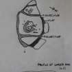
Panel Notes: Tormain 1 is a rhomboid/diamond shaped piece of exposed bedrock, with 2 natural fissures dividing the panel into 3 sections. The top section (most easterly) has no discernible markings, with the middle section containing the largest motif (42 cm in width) with a cup and 3 partial rings, with a terminal at each end forming a cup and ring motif. There are an additional 8 cups/cup and ring motifs within the central section, including a possible dumbbell and 'courgette'. The third (most westerly) section has 3 cupmarks, including a possible dumbbell, and 2 cups with singe intersecting rings. At the bottom of this panel are two previously unrecorded parallel lines (70cm long, 3cm apart) which do not appear to be natural and are possibly an extension of a natural feature.

