Pricing Change
New pricing for orders of material from this site will come into place shortly. Charges for supply of digital images, digitisation on demand, prints and licensing will be altered.
Upcoming Maintenance
Please be advised that this website will undergo scheduled maintenance on the following dates:
Thursday, 9 January: 11:00 AM - 3:00 PM
Thursday, 23 January: 11:00 AM - 3:00 PM
Thursday, 30 January: 11:00 AM - 3:00 PM
During these times, some functionality such as image purchasing may be temporarily unavailable. We apologise for any inconvenience this may cause.
North Muir, 'nether Cairn'
Cairn (Period Unassigned)
Site Name North Muir, 'nether Cairn'
Classification Cairn (Period Unassigned)
Canmore ID 50233
Site Number NT15SW 1
NGR NT 10530 50366
Datum OSGB36 - NGR
Permalink http://canmore.org.uk/site/50233
- Council Scottish Borders, The
- Parish Linton (Tweeddale)
- Former Region Borders
- Former District Tweeddale
- Former County Peebles-shire
NT15SW 1 10530 50366.
(NT 1052 5036) Nether Cairn (NR)
OS 6" map (1957)
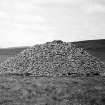
Nether Cairn, situated at about 940ft OD, is 50ft in diameter and 12ft in height. About 3ft outside the present base there are slight indications of a surrounding ditch some 6ft in width.
This cairn is the best preserved example of its kind in Peeblesshire, and appears to be virtually untouched.
RCAHMS 1967, visited 1959
Nether Cairn, name verified. Situated on level moorland, it is as described.
Surveyed at 1/10,000.
Visited by OS (JRL) 23 February 1979
Field Visit (24 June 1943)
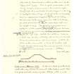
This site was included within the RCAHMS Emergency Survey (1942-3), an unpublished rescue project. Site descriptions, organised by county, vary from short notes to lengthy and full descriptions and are available to view online with contemporary sketches and photographs. The original typescripts, manuscripts, notebooks and photographs can also be consulted in the RCAHMS Search Room.
Information from RCAHMS (GFG) 10 December 2014.
Publication Account (1985)
On the south-east slopes of North Muir is a remarkable collection of nine or so round burial cairns, clustered at around the 280m contour. The Nether Cairn, over 15m in diameter and 3.7m high, is one of the best-preserved, reasonably accessible, round cairns in the area. About 1m beyond the present base are slight indications of a surrounding ditch about 1.8m wide. The Upper Cairn (NT 110509), by contrast, some 730m north-east, is even larger-over 20m across and 4.2m high. Now considerably overgrown, there is no trace of a surrounding ditch, whilst hollows on the east, north and west sides suggest that it has been robbed for its stone. Of the other cairns, one sited 400m north-east of the Upper Cairn still stands about 1m high and over 9m across.
This chain oflarge, round, prehistoric burial cairns in the Dolphinton-West Linton area (there are other, more elevated examples on such Pentland summits as East Cairn Hill, NT 121595; West Cairn Hill, NT 107584; Carnethy Hill, NT 203619) seems to mark an important prehistoric route linking the upper Clyde valley with the Forth estuary. It would have left the Clyde at its junction with the Medwin Water, skirted the south-west of the Pentlands and then followed their south-east flanks before cutting across to the River North Esk-where similar cairns existed near Roslin and Rosewell.
A small, sandstone standing stone, the Gowk Stane (NT 204576), stands just east of Auchencorth Farm on the east bank of the river; it is also on a direct link between the respective groups of round cairns. Moreover, the ruinous remains of an earlier neolithic long cairn-within an equally ruinous plantation dyke-survive as a low ragged mound, nearly 58m by 14m by under 1m high on Harlaw Muir (NT 179546), half way between West Linton and the Gowk Stane and 90m west of the by-road, evidence perhaps of the even greater antiquity of such a through-route.
Information from 'Exploring Scotland's Heritage: Lothian and Borders', (1985).
Sbc Note
Visibility: This is an upstanding earthwork or monument.
Information from Scottish Borders Council


