
Pricing Change
New pricing for orders of material from this site will come into place shortly. Charges for supply of digital images, digitisation on demand, prints and licensing will be altered.
Upcoming Maintenance
Please be advised that this website will undergo scheduled maintenance on the following dates:
Thursday, 30 January: 11:00 AM - 3:00 PM
During these times, some functionality such as image purchasing may be temporarily unavailable. We apologise for any inconvenience this may cause.
Beattock Hill


Building (Medieval) - (Post Medieval), Enclosure (Period Unknown), Hut Circle(S) (Prehistoric)
Site Name Beattock Hill
Classification Building (Medieval) - (Post Medieval), Enclosure (Period Unknown), Hut Circle(S) (Prehistoric)
Canmore ID 48396
Site Number NT00SE 34
NGR NT 0653 0199
NGR Description Centred NT 0653 0199
Datum OSGB36 - NGR
Permalink http://canmore.org.uk/site/48396


- Council Dumfries And Galloway
- Parish Kirkpatrick-juxta
- Former Region Dumfries And Galloway
- Former District Annandale And Eskdale
- Former County Dumfries-shire
NT00SE 34 centred 0653 0199
A homestead generally as described.
Surveyed at 1:10 000
See plan
Visited by OS (T R G) 24 September 1978.
Measured Survey (23 October 1990)
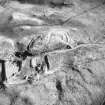
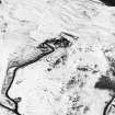
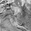
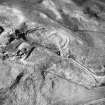
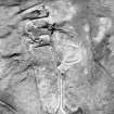
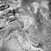
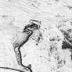
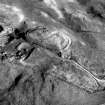
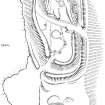
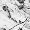
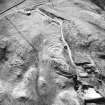
RCAHMS surveyed the fort at Beattock Hill on 23 October 1990 with plane-table and self-reducing alidade at a scale of 1:500. The plan was redrawn in ink and published at a scale of 1:1000 (RCAHMS 1997, Fig. 59).
Field Visit (23 October 1990)
NT00SE 34 centred 0653 0199
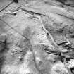
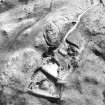
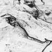
(Formerly classified as Homestead; reclassified as Hut-circles; Enclosure; Building). The remains of at least three hut-circles are situated on a flat terrace immediately below (and to the SSW of) the fort NT00SE 5. Two of them have been reduced to little more than shallow platforms which lie side by side immediately to the N of a later stony bank; that on the NW measures about 10m in diameter, although only a low back-scarp survives, while the other, to the SE, is marked by a low back-scarp with traces of an external bank and measures about 8.5m in diameter. The third hut-circle is better preserved and lies about 35m to the SW; it measures up to 8.5m in diameter within a turf-covered stony bank up to 2.1m thick and 0.4m in high. The interior has been levelled in to the slope on the N, and there is an entrance on the SE. Between the third hut-circle and the two platforms, there are the remains of a later horseshoe-shaped structure (which is open to the SE) and a subrectangular building.
Visited by RCAHMS (JRS), 23 October 1990.
Listed as cairnfield and timber round-houses.
RCAHMS 1997.
Watching Brief (September 2012 - September 2013)
A programme of archaeological works was undertaken by CFA Archaeology Ltd for the grid connection cable between Moffat Substation and the Harestanes Wind Farm Substation.
Several features were discovered on low lying land within the floodplain of the River Annan and its tributaries.
A total of ten pits were discovered on the floodplain of the River Annan and Evan Water. They were devoid of finds or substantial quantities of dateable material although they are likely to be of Roman or prehistoric date. The character of the well-drained gravel-rich natural and the apparent lack of ploughing suggest that potential for further archaeological discoveries in this area must be high.
Three “V” profile ditches were discovered on the site, as were two complete Roman field ovens within the footprint of Bankend Roman Temporary Camp.
A small portion of the original structure of Beattock Bridge was revealed during monitoring of the cable trench excavation. The structural integrity and the appearance of the bridge were unaffected by the development.
Two isolated pits were revealed on a steep south-facing slope to the west of Beattock. Their date is uncertain although they may be associated with the nearby settlement of Beattock Hill.
A northerly extension to Stanshielrig was identified and demarcated to eliminate any impact from the development. A hollow-way, quarry and ditch and bank were excavated ahead of the cable trench works.
A partially surfaced trackway and a drystone bank were recorded to the east of Easter Earshaig.
Funder: Iberdrola Engineering and Construction
CFA Archaeology Ltd
OASIS ID: cfaarcha1-169462

