
Pricing Change
New pricing for orders of material from this site will come into place shortly. Charges for supply of digital images, digitisation on demand, prints and licensing will be altered.
Grangemouth Airfield


Airfield (20th Century), Airport (20th Century)
Site Name Grangemouth Airfield
Classification Airfield (20th Century), Airport (20th Century)
Alternative Name(s) Central Scotland Airport
Canmore ID 90521
Site Number NS98SW 23
NGR NS 93529 80670
NGR Description Centred NS 93529 80670
Datum OSGB36 - NGR
Permalink http://canmore.org.uk/site/90521


- Council Falkirk
- Parish Grangemouth
- Former Region Central
- Former District Falkirk
- Former County Stirlingshire
NS98SW 23.00 centred 93843 80920 (site record is centred on the rough central point of the WWII airfield layout, now located near the play park and reinstated runway surface within Inchyra Park)
NS98SW 23.01 NS 9395 8146 Pillbox
NS98SW 23.02 NS c.9450 8041 Pillbox
NS98SW 23.03 NS c.9468 8101 Pillbox
NS98SW 23.04 NS c.9399 8033 Pillbox
NS98SW 23.04 NS c.9343 8043 Pillbox
NS98SW 23.05 NS c.9343 8043 Pillbox
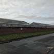
NS98SW 23.06 NS 93641 81363 and NS 93797 81432 Hangars
NS98SW 23.07 NS c.94396 81183 Pillbox
NS98SW 23.08 Centred on N S9389 8149 Air Raid Shelters
For WWII road block at NS c. 9378 8160, see NS98SW 87.
ARCHITECT: Alex Mair, 1939.
(Undated) information in NMRS.
Now totally obliterated by the BP oil refinery and other industrial development.
D J Smith 1983.
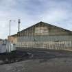
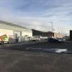
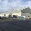
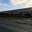
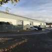
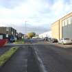
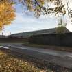
This airfield falls in an area bounded by the A904, B9143, B9132 and A905 roads. The only surviving elements of the airfield are the two large hangars which have been modified. These are in use as factory units within an industrial estate.
J Guy 1999; NMRS MS 810/7, 26-7, P4
Field Visit
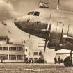
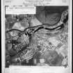
The beginnings of Grangemouth Airfield are unusual and tell a story that might have taken the town and surrounding area down a different path than the industrial one that it is now synonymous with. The airfield covered a large area of todays town, bounded roughly by Bo’ness Road (A904) to the NE, Kersiebank Avenue to the NW/W and a now inaccessible area of land to the SE which is part of various oil refining and manufacturing sites. The airfield at its largest extent, at this stage a simple grassed expanse, is identified in the vertical aerial survey image taken by the Luftwaffe in October of 1939 (SC445486), however having German aerial reconnaissance overhead was only the latest in a fast-moving chain of events at Grangemouth. This 550 acre site had been acquired as the ideal location for a commercial, passenger plane airport in Central Scotland, sitting roughly equi-distant between Glasgow and Edinburgh. The first flights from the fledgling airfield had been made in May of 1939, and it was officially opened two months later as the Central Scotland Airport on the 1st July, complete with an International style terminal building as photographed in SC 1234882. The airport was however, doomed from the start – it was requisitioned as war broke out in September of 1939 and would never open again as a commercial operation. Various military units and operations passed through the airfield and in 1941 it was upgraded with the concrete runways, peritracks and hangar lanes, of which there are several remnants identifiable today.
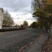
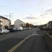
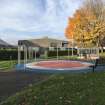
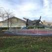
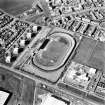
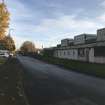
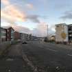
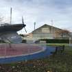
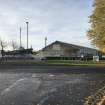
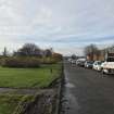
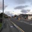
Most obviously, the long stretch of Inchyra Road that is wide and perfectly straight, between the roundabout junction with Boness Road and the site of Grangemouth Stadium, makes use of the footprint of the shorter of the two 1941 runways, this one on a NE – SW axis. The other, longer runway on a roughly E-W axis, is much less recognisable today. Within Inchyra Park, a rectangular public park sitting along the same NE – SW axis as Inchyra Road, a childrens playpark and all-weather sports pitch sits on a small area of the E-W runway footprint. Adjacent to this, a small segment of the former runway has recently been reinstated by the Friends of Inchyra Park community group, along with planters and benches featuring fighter plane decoration, an interpretation board and a painted fighter plane mural on the ground. On the NE periphery of Inchyra Park, a carpark also sits on the footprint of the E-W runway giving a good indication of where the former crossing point of the two runways occurred. This crossing has however, been obliterated by the ribbon of industrial buildings separating the public park and Inchyra Road. To the west of Inchyra Park, the E-W runway is entirely developed in the postwar period. Most notably, the Charlotte Dundas Court shopping precinct indicates the location of the W end of this runway where it intersected the W peritrack of the airfield. The curved stretch of Kingseat Avenue sitting between the road junctions with Maryflats Place to the N and Tinto Drive to the S sits on the footprint of this W peritrack. Beyond the Tinto Drive junction the route of the W peritrack, and the location where it intersected with NE-SW runway, is lost below the footprint of Grangemouth Stadium. To the immediate south of this former intersection location on Inchyra Road, the peritrack again forms the footprint of another smaller post-war road, this time Reddoch Road, a road which was quickly swallowed up by industrial development on the SE edge of the former airfield site.
Grangemouth Airfield was active throughout World War II and continued in declining RAF use throughout the 1940s. A combination of this low level military use, the growth of other industries (in particular a booming but incompatible oil industry) on nearby land and resultant pressure for the town of Grangemouth to expand its housing and industrial needs onto the large airfield site, meant that a return to commercial air travel out of the airfield was increasingly unlikely. In 1952, a fire caused the destruction of the terminal building and a few months later, work started on Turnhouse Airport on the west edge of Edinburgh. Grangemouth Airfield was officially closed in 1955. The OS Map of 1956 shows the airfield in its entirety and undeveloped, though this rapidly changed in the years that followed. The majority of the airfield was developed with housing and amenity uses in the 1960s (the aforementioned shopping precinct, public park and stadium), the aircraft hangars were converted to new industrial uses and the NE-SW axis runway was turned into a road linking Boness Road (the principal route through the early 20th century town) to the newly developed area on the SW grounds of the airfield site. Only the area of the airfields footprint sitting to the SE of Inchyra Road became part of the oil industry expansion, and other related industrial sites (mainly distribution yards and offices) have developed along the edge of Inchyra Road. The wide footprint of the runway that became Inchyra Road has consequently been divided into 3 parts; a support road for the industrial yards, a strip of tree and shrub-planted ground that acts as a buffer to the main carriageways, which became the main link between the industrial zones of the town and the M9 motorway when this was built adjacent to the town in the late 1960s.
IA, HES, 02.11.2020

