
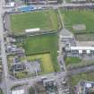
Antonine Wall: Nether Kinneil - Bo'ness


Frontier Defence (Roman)
Site Name Antonine Wall: Nether Kinneil - Bo'ness
Classification Frontier Defence (Roman)
Alternative Name(s) Kinneil Primary School; Maidenpark
Canmore ID 114529
Site Number NS98SE 82
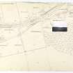
NGR NS 9900 8075
NGR Description NS 9680 8000 to NS 9999 8107
Datum OSGB36 - NGR
Permalink http://canmore.org.uk/site/114529


- Council Falkirk
- Parish Bo'ness And Carriden
- Former Region Central
- Former District Falkirk
- Former County West Lothian
NS98SE 82.00 9680 8000 to 9999 8107
For fortlet at NS 9774 8037, see also NS98SE 15.
Antonine Wall:
NS98SE 82.01 NS 996 809 Dean Road, St Mary's Church [Cancelled]
NS98SE 82.02 NS 986 807 Dean House, Kinneil [Cancelled]
NS98SE 82.03 NS 9754 8016 to NS 9826 8043 Antonine Wall, Military Way
The seventh fortlet (see also NS98SE 15 and NS57SW 50) to be discovered on the Antonine Wall was located and examined and was very similar to that at Seabegs (NS87NW 10). The upper ramparts of the fortlet and the Wall, of earth revetted by turf cheeks, were also built of one.
R Goodburn 1979.
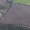
NS 9680 8000 to NS 9724 8015 Rampart exposed in places as a light band of clay with occasional kerb stones (Macdonald 1925).
No surface trace of the Wall in the regularly ploughed fields. The general course is not in doubt. Published course (OS 25 inch 1977) revised.
NS 9723 8013 South kerb of wall-base located (Location measurements given.) (Macdonald 1925).
NS 9724 8015 to NS 9740 8029 No surface trace; a vague depression of the Ditch-line was visible as late as 1957 (Information from OS 1957) Course modified to concur with findings of NS 9730 8019.
NS 9730 8019 Wall and Ditch found by excavation in 1961. Alignment secured (Hendry 1971).
NS 9735 8024 Course apparently confirmed by trenching in 1915 (Macdonald 1925).
NS 9740 8029 to NS 9751 8032 No surface trace. Given the established alignments from NS 9724 8015 to NS 9740 8029 and from NS 9751 8032 to NS 9782 8042, the Ditch must have lain to the N of the present escarpment of the Cowbank. Shallow bedrock here may be a significant factor as to its course.
NS 9751 8032 to NS 9763 8036 No surface trace across landscaped forestry belt. Published course amended to concur with NS 9753 8032.
NS 9753 8032 Base of Wall found by excavation at two points (Macdonald 1925).
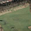
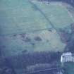
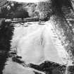
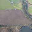
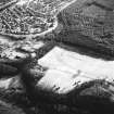
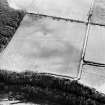
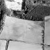
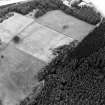
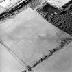
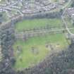
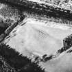
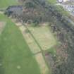
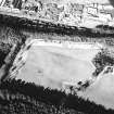
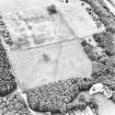
NS 9763 8036 to NS 7982 8042 The much-spread depression of the Ditch-line is clearly visible, some 30m wide and from 0.5m to 1m deep in pasture. Also distinct on RAF vertical aerial photograph (CPE/ SCOT/ UK256, frame no 5437-8, 1947).
The alignment of the Rampart was surveyed at 1:2500 at recent excavations of Kinneil fortlet (see NS98SE 15).
NS 9782 8042 to NS 9786 8045 Ground observations and RAF vertical aerial photograph (CPE/ SCOT/ UK256, frame no 5437-8, 1947) indicate a short, but marked, deflection of the Wall in order to avoid what must have been a SW-NE gully of the Deil's Burn. The exact course of the deflection is confused by an old reservoir. Published course (OS 25 inch 1977) amended.
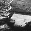
NS 9786 8045 to NS 9800 8049 The much-spread depression of the Ditch-line is clearly visible, some 30m wide and 0.5m to 1m deep, under pasture. (Distinct on RAF vertical aerial photograph (CPE/ SCOT/ UK256, frame no 5437-8, 1947)).
NS 9795 8046 Course of Wall and Ditch determined by trenching at short intervals across the 'Meadows' (Macdonald 1925).
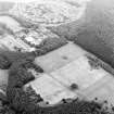
NS 9800 8049 to NS 9810 8051 The much spread hollow of the Ditch line is clearly visible, c. 30m wide and 0.5m deep (see RAF vertical aerial photograph (CPE/ SCOT/ UK256, frame no 5437-8, 1947), (F42/ 58/ 3544, frame no 0371-2, 1960) and RCHAMS aerial photographs WL 1438-9, 1976).
NS 9810 8051 to NS 9818 8053 No surface trace across undulating pasture field (nothing shows on RAF vertical aerial photograph (CPE/ SCOT/ UK256, frame no 5437-8, 1947) F42/ 58/ 3544, frame no 0371-2, 1960, and RCHAMS aerial photographs WL 1438-9, 1976).
NS 9812 8051 Wall trenched in 1915 near E extremity of park and further W.
NS 9815 8047 Course of Wall as shown on OS 1st and 2nd editions of the 2 and a half inch maps refuted by Macdonald as a later 'gallop' (Macdonald 1925).
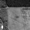
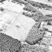
The original OS line is clearly visible as a spread depression c. 1.5m deep that forms a sharp junction with the Antonine Wall Ditch at NS 9810 8051 and extends to, and possibly beyond, the Gil Burn. This linear feature is not convincing as a 'gallop' or medieval work (see NS98SE 10), and could well be an original dog-leg of the Wall that avoids the steep ravine of the Gil Burn. If this is so, the return angle back to the established course at NS 9837 8058 is not obvious. This view must somewhat conflict with Macdonald's (1925) findings at NS 9812 8051 and at NS 9827 8056, which have been respected. (See RAF vertical aerial photograph (CPE/ SCOT/ UK256, frame no 5437-8, 1947) F42/ 58/ 3544, frame no 0371-2, 1960, and RCHAMS aerial photographs WL 1438-9, 1976).
NS 9827 8056 Subsidence along N wall of garden (Macdonald 1925).
Subsidence evidence of garden wall tenuous; of great age, this may be a natural collapse.
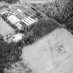
NS 9837 8058 to NS 9900 8078 New path and other alterations leave only amorphous traces of Ditch line at NS 9858 8065; otherwise there is no trace, firstly across developed area and then a pasture field.
NS 9837 8058 Base of Wall and Ditch revealed by excavation in 1961. Ditch 28ft (8.5m) wide, Berm 24ft (7.3m), Wall c. 14ft (4.3m) (Hendry 1971).
NS 9855 8064 Ditch visible as a spread hollow some 23m wide and 0.5m deep (Information from OS 1957).
NS 9858 8065 Ditch visible as dip in W bank of Gil Burn (Dean Burn) (Robertson 1973).
NS 9870 8068 At Dean House, Kinneil, Stirlingshire, in July and August, 1960 a limited excavation, supervised by Mr. G. Maxwell and Mr. J. Wallace, was carried out in the policies of Dean House, recently demolished, to examine the possibility that a Roman fort existed on the site overlooking the Dean Burn (see NS98SE 9). The Antonine ditch was found, only 18ft. wide instead of the expected standard 40ft. No fort existed. The fort long conjectured in the vicinity is most probably near Kinneil House by the Gil Burn (Cruden 1960).
Ditch found by excavation in 1960 (Steer 1963)
NS 9874 8070 Ditch located by trenching in 1915 (Macdonald 1925)
NS 9900 8078 to NS 9999 8107 The line of the Ditch is presumed occupied by Dean Road (Macdonald 1934).
Published course (OS 25 inch 1960) accepted. There is no evidence found to doubt the established line.
Information from OS 1980
S H Cruden 1960; T A Hendry 1971; G Macdonald 1925, 1934; A S Robertson 1973; K A Steer 1963.
NS 9956 8092 Excavation in advance of building work located the localized remnants of the Antonine wall base adjacent to Dean Road. The remaining section included a culvert, much disturbed where cultivation had begun in the field to the E. 7.8m to the N was the Ditch which lies largely under the S pavement of Dean Road. 1.8m S of the S lip of the Ditch a small U-shaped channel, 35cm wide was located. Sponsor: Falkirk Museum.
G Bailey 1989.
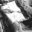
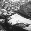
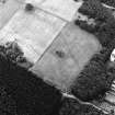
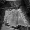
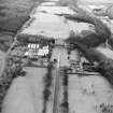
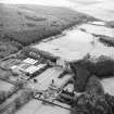
NS 9774 8038 In the 1970's fieldwalking by members of the Cumbernauld Historical Society produced Roman pottery from the fields W of Kinneil House and focused attention on a small knoll 500m W of the house. Subsequent trial excavations in 1978-80 (Keppie and Walker 1981) proved the existence of Kenneil fortlet (NS98SE 15) at this location, attached to the Antonine Wall. A 30m length of the Antonine Wall was systematically stripped of topsoil. A further 11m of the Wall's S kerb only was exposed to the E of this. The Rampart was of normal construction for this sector, consisting of a foundation of dressed kerbstones infilled with rubble, set directly onto the natural clay and gravel and surmounted by a superstructures of brown-red clay loam revetted with turf or clay cheeks (see also Robertson, Scott and Keppie 1975). The Wall varied from 4.2m to 4.3m in width over the excavated length. Individual kerbstones, though widely varied in size, averaged 0.4m long at the exposed face, sitting 0.2m proud of the subsoil. There was a distinct lateral variation in the size and composition of the material used in the core (i.e. rubble fill consisted of large angular sandstone slabs to the W of the north gate and small boulders E of the gate), which indicates that it was derived from a number of different sources. Also a broken quern stone of native form was incorporated into the rubble core. There was no break in the stonework between the Antonine Wall and the E rampart of the fortlet. However, within the base of the Wall, there was an alignment of stones running at right angles from the N kerb towards the centre of the fortlet rampart on line with the S kerb of the Antonine Wall. The stones were arranged to form a fair or regular face along their western edge. This may indicate demarcation lines where there was a change in work gangs, also paralleled at other excavations (Keppie and Breeze 1981). Survival of the earth and turf or clay superstructure was fragmentary. E of the north gate, up to 0.4m of the superstructure survived, though slumping and disturbances had been severe. Finds sealed by the collapse superstructure of the Wall include quantities of Black-burnished ware and two amphora rims from beyond the N kerb. A quantity of butchered cattle bone and a decorated bronze harness strap junction were found in the disturbed material in the interior.
Three small trenches were placed across the S lip of the Ditch. None of these trenches were fully bottomed, excavation stopping when the position of the Ditch edge had been confirmed in each case. There is no sign of a causeway across the Ditch associated with the fortlet's N gateway. The berm between the Wall and Ditch varied from a narrow 4m in the E trench, to 8.4m in the W trench. Similarly as the berm broadens so the Ditch narrows.
G B Bailey and J Cannel 1996
A S Robertson, M Scott and L Keppie 1975; L J F Keppie and D J Breeze 1982; L J F Keppie and J J Walker 1981.
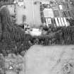
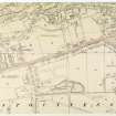
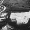
NS 9827 8056 In 1990 Falkirk District Council rationalised its horticultural activities by constructing facilities in the walled garden in the Kinneil Estate. This area also coincides with the line of the Antonine Wall as represented on the current edition of the OS 1:10,000 mapsheet, 1984). Unfortunately, no archaeological recording took place due to the lack of notification prior to development. Workmen stated that no stonework had been removed, nor did there appear to be any trace of a ditch cut through the bedrock (the natural rock is near the surface in this area). Two possibilities could explain the course of the Wall. One possibility is that it lay directly along the line of the N wall of the garden as suggested by Macdonald (1925). The second possibility places the Wall to the S as originally delineated on the 1st edition of the OS 2 and a half inch (Stirlingshire 1860, sheet 30) and by Buchanan in 1902 (information from Falkirk Museum a67.11). However, aerial photographs (Courtesy of the Cambridge University Committee for Aerial Photographs) clearly show a ditch-like feature on the line given by the OS.
G B Bailey 1996
G Macdonald 1925.
NS 9819 8050 The Ditch was detected running on a E-W alignment. It lay below a later cobbled path and was therefore located with some difficulty. The Ditch had a width of c.7.5m, and was only excavated to a depth of 0.6m. The exposed fills consisted of a series of clayey silts and silty clays, suggesting natural silting rather than deliberate backfilling. About 1.7m N of the Ditch, a slight bank some 9.8m wide was present, and is probably the remains of the Outer Mound.
The proposed second line of the Ditch, suggested by previous writers (Robertson 1990; Bailey 1996), was not identified. Although the trench extended c.20m to the S of the E-W Ditch neither the Rampart nor any other associated Roman features were present within the trench.
NS 9813 8050 The Ditch was located on an E-W alignment. It had a surface width of c.8m. A small section was excavated into its N side, revealing its edge to be steep-sided. No trace of the Rampart survived. Two small negative features were located in the area of the Berm,. These were not excavated. They may be 'defensive pits' such as those found at Callendar Park (Bailey 1995) and Inveravon (Dunwell and Ralston 1995), however extensive excavation would need to confirm this.
The results of this excavation suggest that the large hollow excavated by Bailey (1996) within the walled garden of Kinneil House is not the re-entrant angle of a proposed divergent line of the Ditch. Given its position to the S of Kinneil House, it may represent a defensive feature related to the Palace of Kinneil and enclosing it on its eastern side. Alternatively, it could represent the remains of a defensive ditch from the proposed Roman fort at Kinneil (Hanson and Maxwell 1983)
B Glendinning 2000
G B Bailey 1995, 1996; A Dunwell and I Ralston 1995; W S Hanson and G S Maxwell 1983; A S Robertson 1990.
NS98SE 82 996 809
A N-S trench was placed along the W boundary of the church's land, by G B Bailey, to cross the Antonine Wall. The wall base was badly damaged with no trace of any surviving superstructure, some of the remaining stones bore grooves cut by the plough. The ditch was located 7.8m N of the rampart.
L J F Keppie et al 1995.
[NS 99406 80901 to NS 99647 80971]. Length scheduled as 'Antonine Wall, N of Kinneil Primary School.'
Information from Historic Scotland, scheduling document dated 26 November 2009.
Following lengths scheduled as 'Antonine Wall and fortlet, 430m E to 850m WSW of Kinneil House... a stretch of the Antonine Wall surviving as a combination of buried deposits and visible earthworks located through aerial photography, geophysical survey and... excavation at several points along its line':
NS c. 97396 80285 to c. 97808 80431
NS c. 97844 80431 to c. 98165 80552
NS c. 98337 80578 to c. 98641 80680.
[Scheduled area includes fortlet NS98SW 15: location map supplied].
Information from Historic Scotland, scheduling document dated 25 June 2010.
Excavation (1915)
NS 9735 8024 Course apparently confirmed by trenching in 1915 (Macdonald 1925).
Excavation (1915)
NS 9812 8051 Wall trenched in 1915 near E extremity of park and further W.
Field Visit (1925)
NS 9680 8000 to NS 9724 8015 Rampart exposed in places as a light band of clay with occasional kerb stones (Macdonald 1925).
Field Visit (1925)
NS 9827 8056 Subsidence along N wall of garden (Macdonald 1925).
Subsidence evidence of garden wall tenuous; of great age, this may be a natural collapse.
Excavation (1925)
NS 9795 8046 Course of Wall and Ditch determined by trenching at short intervals across the 'Meadows' (Macdonald 1925).
Excavation (1925)
NS 9753 8032 Base of Wall found by excavation at two points (Macdonald 1925).
Field Visit (1925)
NS 9723 8013 South kerb of wall-base located (Location measurements given.) (Macdonald 1925).
Field Visit (1934)
NS 9900 8078 to NS 9999 8107 The line of the Ditch is presumed occupied by Dean Road (Macdonald 1934).
Aerial Photography (11 July 1951)
Field Visit (1957)
NS 9855 8064 Ditch visible as a spread hollow some 23m wide and 0.5m deep (Information from OS 1957).
Excavation (July 1960 - August 1960)
NS 9870 8068 At Dean House, Kinneil, Stirlingshire, in July and August, 1960 a limited excavation, supervised by Mr. G. Maxwell and Mr. J. Wallace, was carried out in the policies of Dean House, recently demolished, to examine the possibility that a Roman fort existed on the site overlooking the Dean Burn (see NS98SE 9). The Antonine ditch was found, only 18ft. wide instead of the expected standard 40ft. No fort existed. The fort long conjectured in the vicinity is most probably near Kinneil House by the Gil Burn (Cruden 1960).
Ditch found by excavation in 1960 (Steer 1963)
Excavation (3 July 1961 - 14 July 1961)
NS 9730 8019 Wall and Ditch found by excavation in 1961. Alignment secured (Hendry 1971).
NS 9837 8058 Base of Wall and Ditch revealed by excavation in 1961. Ditch 28ft (8.5m) wide, Berm 24ft (7.3m), Wall c. 14ft (4.3m) (Hendry 1971).
Excavation (1961)
NS 9837 8058 Base of Wall and Ditch revealed by excavation in 1961. Ditch 28ft (8.5m) wide, Berm 24ft (7.3m), Wall c. 14ft (4.3m) (Hendry 1971).
Aerial Photography (27 July 1963)
Field Visit (1973)
NS 9858 8065 Ditch visible as dip in W bank of Gil Burn (Dean Burn) (Robertson 1973).
Aerial Photography (31 July 1975)
Excavation (1978 - 1979)
NS 977 803.
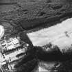
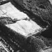
Following discoveries of Roman pottery by Cumbernauld Hist Soc, excavation in 1978 and 1979 revealed the remains of a fortlet attached to the Antonine Wall. It measures internally c18m E-W by c21m within a plough damaged, 3.0m wide, stone-based rampart. This was best preserved at the N gate and NE corner and it was bonded with the Wall. The upper ramparts of fortlet and Wall, of earth revetted by turf cheeks, were also of one build. The N gate was 3.5m wide with a rammed pebble road running through it; a single post-hole was located on its W side. Towards the E side was a stone culvert, some capstones of which remained in position. There was at least one defensive ditch, 1.8m wide and 70cm deep, located only on the S side; the berm here was c 9.5m wide.
L J F Keppie and J J Walker 1979; R Goodburn 1979.
The seventh fortlet (see also NS98SE 15 and NS57SW 50) to be discovered on the Antonine Wall was located and examined and was very similar to that at Seabegs (NS87NW 10). The upper ramparts of the fortlet and the Wall, of earth revetted by turf cheeks, were also built of one.
R Goodburn 1979.
Subsequent trial excavations in 1978-80 (Keppie and Walker 1981) proved the existence of Kenneil fortlet (NS98SE 15) at this location, attached to the Antonine Wall. A 30m length of the Antonine Wall was systematically stripped of topsoil. A further 11m of the Wall's S kerb only was exposed to the E of this. The Rampart was of normal construction for this sector, consisting of a foundation of dressed kerbstones infilled with rubble, set directly onto the natural clay and gravel and surmounted by a superstructures of brown-red clay loam revetted with turf or clay cheeks (see also Robertson, Scott and Keppie 1975). The Wall varied from 4.2m to 4.3m in width over the excavated length. Individual kerbstones, though widely varied in size, averaged 0.4m long at the exposed face, sitting 0.2m proud of the subsoil. There was a distinct lateral variation in the size and composition of the material used in the core (i.e. rubble fill consisted of large angular sandstone slabs to the W of the north gate and small boulders E of the gate), which indicates that it was derived from a number of different sources. Also a broken quern stone of native form was incorporated into the rubble core. There was no break in the stonework between the Antonine Wall and the E rampart of the fortlet. However, within the base of the Wall, there was an alignment of stones running at right angles from the N kerb towards the centre of the fortlet rampart on line with the S kerb of the Antonine Wall. The stones were arranged to form a fair or regular face along their western edge. This may indicate demarcation lines where there was a change in work gangs, also paralleled at other excavations (Keppie and Breeze 1981). Survival of the earth and turf or clay superstructure was fragmentary. E of the north gate, up to 0.4m of the superstructure survived, though slumping and disturbances had been severe. Finds sealed by the collapse superstructure of the Wall include quantities of Black-burnished ware and two amphora rims from beyond the N kerb. A quantity of butchered cattle bone and a decorated bronze harness strap junction were found in the disturbed material in the interior.
Three small trenches were placed across the S lip of the Ditch. None of these trenches were fully bottomed, excavation stopping when the position of the Ditch edge had been confirmed in each case. There is no sign of a causeway across the Ditch associated with the fortlet's N gateway. The berm between the Wall and Ditch varied from a narrow 4m in the E trench, to 8.4m in the W trench. Similarly as the berm broadens so the Ditch narrows.
G B Bailey and J Cannel 1996
A S Robertson, M Scott and L Keppie 1975; L J F Keppie and D J Breeze 1982; L J F Keppie and J J Walker 1981.
Ground Survey (1978)
The alignment of the Rampart was surveyed at 1:2500 at recent excavations of Kinneil fortlet (see NS98SE 15).
Field Visit (1980)
NS 9680 8000 to NS 9724 8015 No surface trace of the Wall in the regularly ploughed fields. The general course is not in doubt. Published course (OS 25 inch 1977) revised.
Information from OS 1980
Aerial Photographic Interpretation (1980)
NS 9763 8036 to NS 7982 8042 The much-spread depression of the Ditch-line is clearly visible, some 30m wide and from 0.5m to 1m deep in pasture. Also distinct on RAF vertical aerial photograph (CPE/ SCOT/ UK256, frame no 5437-8, 1947).
Information from OS 1980
Aerial Photographic Interpretation (1980)
NS 9782 8042 to NS 9786 8045 Ground observations and RAF vertical aerial photograph (CPE/ SCOT/ UK256, frame no 5437-8, 1947) indicate a short, but marked, deflection of the Wall in order to avoid what must have been a SW-NE gully of the Deil's Burn. The exact course of the deflection is confused by an old reservoir. Published course (OS 25 inch 1977) amended.
Information from OS 1980
Field Visit (1980)
NS 9782 8042 to NS 9786 8045 Ground observations and RAF vertical aerial photograph (CPE/ SCOT/ UK256, frame no 5437-8, 1947) indicate a short, but marked, deflection of the Wall in order to avoid what must have been a SW-NE gully of the Deil's Burn. The exact course of the deflection is confused by an old reservoir. Published course (OS 25 inch 1977) amended.
Information from OS 1980
Aerial Photographic Interpretation (1980)
NS 9786 8045 to NS 9800 8049 The much-spread depression of the Ditch-line is clearly visible, some 30m wide and 0.5m to 1m deep, under pasture. (Distinct on RAF vertical aerial photograph (CPE/ SCOT/ UK256, frame no 5437-8, 1947)).
Information from OS 1980
Aerial Photographic Interpretation (1980)
NS 9800 8049 to NS 9810 8051 The much spread hollow of the Ditch line is clearly visible, c. 30m wide and 0.5m deep (see RAF vertical aerial photograph (CPE/ SCOT/ UK256, frame no 5437-8, 1947), (F42/ 58/ 3544, frame no 0371-2, 1960) and RCHAMS aerial photographs WL 1438-9, 1976).
Information from OS 1980
Field Visit (1980)
NS 9815 8047 Course of Wall as shown on OS 1st and 2nd editions of the 2 and a half inch maps refuted by Macdonald as a later 'gallop' (Macdonald 1925).
The original OS line is clearly visible as a spread depression c. 1.5m deep that forms a sharp junction with the Antonine Wall Ditch at NS 9810 8051 and extends to, and possibly beyond, the Gil Burn. This linear feature is not convincing as a 'gallop' or medieval work (see NS98SE 10), and could well be an original dog-leg of the Wall that avoids the steep ravine of the Gil Burn. If this is so, the return angle back to the established course at NS 9837 8058 is not obvious. This view must somewhat conflict with Macdonald's (1925) findings at NS 9812 8051 and at NS 9827 8056, which have been respected. (See RAF vertical aerial photograph (CPE/ SCOT/ UK256, frame no 5437-8, 1947) F42/ 58/ 3544, frame no 0371-2, 1960, and RCHAMS aerial photographs WL 1438-9, 1976).
Information from OS 1980
Field Visit (1980)
NS 9810 8051 to NS 9818 8053 No surface trace across undulating pasture field (nothing shows on RAF vertical aerial photograph (CPE/ SCOT/ UK256, frame no 5437-8, 1947) F42/ 58/ 3544, frame no 0371-2, 1960, and RCHAMS aerial photographs WL 1438-9, 1976).
Information from OS 1980
Field Visit (1980)
NS 9837 8058 to NS 9900 8078 New path and other alterations leave only amorphous traces of Ditch line at NS 9858 8065; otherwise there is no trace, firstly across developed area and then a pasture field.
Information from OS 1980
Field Visit (1980)
NS 9900 8078 to NS 9999 8107 Published course (OS 25 inch 1960) accepted. There is no evidence found to doubt the established line.
Information from OS 1980
Field Visit (1980)
NS 9751 8032 to NS 9763 8036 No surface trace across landscaped forestry belt. Published course amended to concur with NS 9753 8032.
Information from OS 1980
Field Visit (1980)
NS 9740 8029 to NS 9751 8032 No surface trace. Given the established alignments from NS 9724 8015 to NS 9740 8029 and from NS 9751 8032 to NS 9782 8042, the Ditch must have lain to the N of the present escarpment of the Cowbank. Shallow bedrock here may be a significant factor as to its course.
Information from OS 1980
Field Visit (1980)
NS 9724 8015 to NS 9740 8029 No surface trace; a vague depression of the Ditch-line was visible as late as 1957 (Information from OS 1957) Course modified to concur with findings of NS 9730 8019.
Information from OS 1980
Excavation (February 1989)
NS 9956 8092 Excavation in advance of building work located the localized remnants of the Antonine wall base adjacent to Dean Road. The remaining section included a culvert, much disturbed where cultivation had begun in the field to the E. 7.8m to the N was the Ditch which lies largely under the S pavement of Dean Road. 1.8m S of the S lip of the Ditch a small U-shaped channel, 35cm wide was located. Sponsor: Falkirk Museum.
G Bailey 1989.
NS98SE 82 996 809
Salvage Record (1990)
NS 9827 8056 In 1990 Falkirk District Council rationalised its horticultural activities by constructing facilities in the walled garden in the Kinneil Estate. This area also coincides with the line of the Antonine Wall as represented on the current edition of the OS 1:10,000 mapsheet, 1984). Unfortunately, no archaeological recording took place due to the lack of notification prior to development. Workmen stated that no stonework had been removed, nor did there appear to be any trace of a ditch cut through the bedrock (the natural rock is near the surface in this area). Two possibilities could explain the course of the Wall. One possibility is that it lay directly along the line of the N wall of the garden as suggested by Macdonald (1925). The second possibility places the Wall to the S as originally delineated on the 1st edition of the OS 2 and a half inch (Stirlingshire 1860, sheet 30) and by Buchanan in 1902 (information from Falkirk Museum a67.11). However, aerial photographs (Courtesy of the Cambridge University Committee for Aerial Photographs) clearly show a ditch-like feature on the line given by the OS.
G B Bailey 1996
G Macdonald 1925.
Publication Account (1995)
A N-S trench was placed along the W boundary of the church's land, by G B Bailey, to cross the Antonine Wall. The wall base was badly damaged with no trace of any surviving superstructure, some of the remaining stones bore grooves cut by the plough. The ditch was located 7.8m N of the rampart.
L J F Keppie et al 1995
Trial Trench (February 1998)
NS 981 804 A programme of geophysical survey and trial excavations took place on the line of the Antonine Wall as part of Historic Scotland's review of the Scheduling of this monument. To the W of the Gil Burn aerial photographs show two distinct broad linear features, both consistent in appearance with the Antonine Wall ditch (see PSAS 126, 364, illus 15). The first runs E-W, and has been previously confirmed as an alignment of the Roman frontier; a second ditched feature appears to diverge from the E-W line and runs S to cross the Gil Burn further upstream. This latter has been considered as a possible second frontier feature alignment. The present work was designed to establish whether two frontier arrangements existed here and, if so, to examine the relationship between them. The grounds at Kinneil were also the site of a medieval village which was cleared in the 17th century by the owners of Kinneil House to create parkland.
The geophysical survey located two linear anomalies corresponding to those identified on the aerial photographs, as well as the remains of one definite rectilinear structure and a second possible structure.
Four trenches were excavated, located with reference to the aerial photographs and the results of the geophysical survey. The excavations revealed the Antonine Wall on its E-W alignment, confirming previous observations. The ditched feature diverging from this line to the SE was found to be a cobbled path set in a hollow; it is probably a path, and was presumably part of the 17th-century landscaping.
The remains of a beam slot, a paved area, a well, and stone walls were discovered at various points in the trenches, and relate to the former Kinneil village. Artefacts recovered during the excavations comprise pottery, glass, clay pipe and a silver long cross penny dating to Alexander III 2nd coinage c 1280-86.
A report has been lodged with the NMRS.
Sponsor: Historic Scotland
B Glendinning 1998; L J F Keppie 1999
Resistivity (February 1998)
Grid A
NS98SE RRX505 986 807
NS 981 804 A programme of geophysical survey and trial excavations took place on the line of the Antonine Wall as part of Historic Scotland's review of the Scheduling of this monument. To the W of the Gil Burn aerial photographs show two distinct broad linear features, both consistent in appearance with the Antonine Wall ditch (see PSAS 126, 364, illus 15). The first runs E-W, and has been previously confirmed as an alignment of the Roman frontier; a second ditched feature appears to diverge from the E-W line and runs S to cross the Gil Burn further upstream. This latter has been considered as a possible second frontier feature alignment. The present work was designed to establish whether two frontier arrangements existed here and, if so, to examine the relationship between them. The grounds at Kinneil were also the site of a medieval village which was cleared in the 17th century by the owners of Kinneil House to create parkland.
The geophysical survey located two linear anomalies corresponding to those identified on the aerial photographs, as well as the remains of one definite rectilinear structure and a second possible structure.
Four trenches were excavated, located with reference to the aerial photographs and the results of the geophysical survey. The excavations revealed the Antonine Wall on its E-W alignment, confirming previous observations. The ditched feature diverging from this line to the SE was found to be a cobbled path set in a hollow; it is probably a path, and was presumably part of the 17th-century landscaping.
The remains of a beam slot, a paved area, a well, and stone walls were discovered at various points in the trenches, and relate to the former Kinneil village. Artefacts recovered during the excavations comprise pottery, glass, clay pipe and a silver long cross penny dating to Alexander III 2nd coinage c 1280-86.
A report has been lodged with the NMRS.
Sponsor: Historic Scotland
B Glendinning 1998; L J F Keppie 1999
Resistivity (February 1998)
Grid B
NS98SE RRX505 986 807
NS 981 804 A programme of geophysical survey and trial excavations took place on the line of the Antonine Wall as part of Historic Scotland's review of the Scheduling of this monument. To the W of the Gil Burn aerial photographs show two distinct broad linear features, both consistent in appearance with the Antonine Wall ditch (see PSAS 126, 364, illus 15). The first runs E-W, and has been previously confirmed as an alignment of the Roman frontier; a second ditched feature appears to diverge from the E-W line and runs S to cross the Gil Burn further upstream. This latter has been considered as a possible second frontier feature alignment. The present work was designed to establish whether two frontier arrangements existed here and, if so, to examine the relationship between them. The grounds at Kinneil were also the site of a medieval village which was cleared in the 17th century by the owners of Kinneil House to create parkland.
The geophysical survey located two linear anomalies corresponding to those identified on the aerial photographs, as well as the remains of one definite rectilinear structure and a second possible structure.
Four trenches were excavated, located with reference to the aerial photographs and the results of the geophysical survey. The excavations revealed the Antonine Wall on its E-W alignment, confirming previous observations. The ditched feature diverging from this line to the SE was found to be a cobbled path set in a hollow; it is probably a path, and was presumably part of the 17th-century landscaping.
The remains of a beam slot, a paved area, a well, and stone walls were discovered at various points in the trenches, and relate to the former Kinneil village. Artefacts recovered during the excavations comprise pottery, glass, clay pipe and a silver long cross penny dating to Alexander III 2nd coinage c 1280-86.
A report has been lodged with the NMRS.
Sponsor: Historic Scotland
B Glendinning 1998; L J F Keppie 1999
Aerial Photographic Interpretation (February 1998)
NS98SE RRX505 986 807
NS 981 804 A programme of geophysical survey and trial excavations took place on the line of the Antonine Wall as part of Historic Scotland's review of the Scheduling of this monument. To the W of the Gil Burn aerial photographs show two distinct broad linear features, both consistent in appearance with the Antonine Wall ditch (see PSAS 126, 364, illus 15). The first runs E-W, and has been previously confirmed as an alignment of the Roman frontier; a second ditched feature appears to diverge from the E-W line and runs S to cross the Gil Burn further upstream. This latter has been considered as a possible second frontier feature alignment. The present work was designed to establish whether two frontier arrangements existed here and, if so, to examine the relationship between them. The grounds at Kinneil were also the site of a medieval village which was cleared in the 17th century by the owners of Kinneil House to create parkland.
The geophysical survey located two linear anomalies corresponding to those identified on the aerial photographs, as well as the remains of one definite rectilinear structure and a second possible structure.
Four trenches were excavated, located with reference to the aerial photographs and the results of the geophysical survey. The excavations revealed the Antonine Wall on its E-W alignment, confirming previous observations. The ditched feature diverging from this line to the SE was found to be a cobbled path set in a hollow; it is probably a path, and was presumably part of the 17th-century landscaping.
The remains of a beam slot, a paved area, a well, and stone walls were discovered at various points in the trenches, and relate to the former Kinneil village. Artefacts recovered during the excavations comprise pottery, glass, clay pipe and a silver long cross penny dating to Alexander III 2nd coinage c 1280-86.
A report has been lodged with the NMRS.
Sponsor: Historic Scotland
B Glendinning 1998; L J F Keppie 1999
Publication Account (2000)
NS 9819 8050 The Ditch was detected running on a E-W alignment. It lay below a later cobbled path and was therefore located with some difficulty. The Ditch had a width of c.7.5m, and was only excavated to a depth of 0.6m. The exposed fills consisted of a series of clayey silts and silty clays, suggesting natural silting rather than deliberate backfilling. About 1.7m N of the Ditch, a slight bank some 9.8m wide was present, and is probably the remains of the Outer Mound.
The proposed second line of the Ditch, suggested by previous writers (Robertson 1990; Bailey 1996), was not identified. Although the trench extended c.20m to the S of the E-W Ditch neither the Rampart nor any other associated Roman features were present within the trench.
NS 9813 8050 The Ditch was located on an E-W alignment. It had a surface width of c.8m. A small section was excavated into its N side, revealing its edge to be steep-sided. No trace of the Rampart survived. Two small negative features were located in the area of the Berm,. These were not excavated. They may be 'defensive pits' such as those found at Callendar Park (Bailey 1995) and Inveravon (Dunwell and Ralston 1995), however extensive excavation would need to confirm this.
The results of this excavation suggest that the large hollow excavated by Bailey (1996) within the walled garden of Kinneil House is not the re-entrant angle of a proposed divergent line of the Ditch. Given its position to the S of Kinneil House, it may represent a defensive feature related to the Palace of Kinneil and enclosing it on its eastern side. Alternatively, it could represent the remains of a defensive ditch from the proposed Roman fort at Kinneil (Hanson and Maxwell 1983)
B Glendinning 2000
G B Bailey 1995, 1996; A Dunwell and I Ralston 1995; W S Hanson and G S Maxwell 1983; A S Robertson 1990.
NS98SE RRX505 986 807
Archaeological Evaluation (1 October 2016 - 30 November 2016)
NS 97480 80320 - This evaluation was carried out in support of the design of access improvement work for a footpath along a stretch of the Antonine Wall in Kinneil Woods. All works were conducted under the terms of Scheduled Monument Consent, issued and overseen by Historic Environment Scotland.
Three trenches were excavated within the study area to characterise the visible bank running on the top lip of the Cow Bank, and the character of the existing path immediately downslope. The bank proved to be a relatively slight simple earthen feature, while the modern path lay within a much broader ledge that appears to have been cut when it was built. The only artefact recovered was a ceramic base sherd from a white glazed pottery vessel of post medieval or later date from within bank material.
While the works provide information to assist the design work, no conclusive information was garnered as to the origin of the visible bank. By inference, it is slightly more likely this is a post-medieval feature – but this cannot be confirmed.
Information from OASIS ID: rathmell1-270018 (L McKinstry) 2016
Archaeological Evaluation (19 April 2017 - 21 April 2017)
An archaeological evaluation was carried out in support of the design of an access route onto an existing footpath within the Antonine Wall World Heritage Site at Kinneil Woods, Falkirk. Three trenches, excavated by hand, revealed evidence of 19th or 20th century quarrying cutting into naturally occurring subsoil layers and bedrock. No Roman strata or artefacts were identified in any of the excavated trenches which suggested that the Antonine Wall within the site area had either been fully or partially destroyed by the quarrying or that it may have run further to the south of the site within an adjacent field.
Information from Liam McKinstry (Rathmell Archaeology Ltd) 12 May 2017.
OASIS ID: rathmell1-284234
Archaeological Evaluation (24 January 2017)
ARCHAS Cultural Heritage Ltd were contracted to undertake an archaeological evaluation at 90 Dean Road in Bo'ness in Falkirk Council area. The site is subject to a pre-planning application to Falkirk Council which has identified the potential of archaeological concerns affecting any proposed development. The site partly lies within the Antonine Wall UNESCO World Heritage Site and as such is considered an area of great archaeological significance. The official response to the pre-planning application from Falkirk Council required that a programme of archaeological evaluation be completed in advance of the proposed development. The archaeological evaluation involved the mechanical excavation of two evaluation trenches at the southern end of the site, running perpendicularly to the line of the Antonine Wall. The evaluation revealed the denuded remains of the large defensive bank known to lie on the northern side of the Antonine Wall ditch. This extended around 5m into the proposed development area, the remainder of which was shown to be devoid of significant archaeological deposits or features. ARCHAS Cultural Heritage Ltd recommend that no further archaeological mitigation be required on site. Any excavations at the southern end of the development area are not expected to disturb the remains of the upcast bank, while no structures will be built directly overlying the recorded remains to impinge upon the line of the Antonine Wall World Heritage Area.
Information from Ross Cameron (ARCHAS Cultural Heritage Ltd) 16 February 2017.
OASIS ID: archascu1-274128

