
Scheduled Maintenance
Please be advised that this website will undergo scheduled maintenance on the following dates: •
Tuesday 3rd December 11:00-15:00
During these times, some services may be temporarily unavailable. We apologise for any inconvenience this may cause.
Kincardine On Forth Bridge


Road Bridge (20th Century)
Site Name Kincardine On Forth Bridge
Classification Road Bridge (20th Century)
Alternative Name(s) Kincardine Bridge; River Forth
Canmore ID 48119
Site Number NS98NW 59
NGR NS 92560 87164
NGR Description NS 92134 86942 to NS 92831 87305
Datum OSGB36 - NGR
Permalink http://canmore.org.uk/site/48119


First 100 images shown. See the Collections panel (below) for a link to all digital images.
- Council Fife
- Parish Tulliallan
- Former Region Fife
- Former District Dunfermline
- Former County Fife
NS98NW 59 92560 87164 (NS 92134 86942 to NS 92831 87305)
Kincardine on Forth Bridge [NAT]
OS 1:10,000 map, 1991.
Location formerly entered as NS 92561 87163.
Not to be confused with later (fixed) Clackmannanshire Bridge (also known as Upper Forth Crossing) built upstream at NS c. 9206 8836 to c. 9201 8693: see NS98NW 342.
Central swing span at NS 92560 87163.
(Undated) information in NMRS.
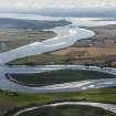
(Location cited as NS 921 869 - NS 928 873). Kincardine Bridge, opened 1936. Steel-girder bridge, 2,696ft (822m) long with a central 364ft (111m) swing span, in the form of a steel truss with central bowed portion.
J R Hume 1976.
By Alexander Gibb & Partners, 1932-6, and the earliest road crossing over the Forth built E of Stirling. Steel girders on concrete piers, the central section made to open. Quite straightforward, apart from suburban Art Deco concrete decoration above bridge level.
J Gifford 1988.
The bridge spans the Forth at Kincardine. There are no changes to the NMR description. A new bridge is under consideration because of the poor condition of the existing bridge.
Site recorded by GUARD during the Coastal Assessment Survey for Historic Scotland, 'The Firth of Forth from Dunbar to the Coast of Fife' , 21 February 1996.
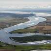
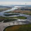
This bridge carries the A876 (T) public road over the River Forth immediately SW of the town of Kincardine (NS98NW 48); the river here forms the barrier between the parishes of Tulliallan (Fife) and Airth (Stirlingshire). The swinging mechanism is no longer operational, and the fixed bridge forms a significant barrier to navigation. The bridge is approached up a curving concrete-based North Approach Road from the NE, and up a gently-sloping ramp from the SW.
Information from RCAHMS (RJCM), 8 December 2000.
The location assigned to this record defines the central pivot of the swinging span, which apparently extends from NS c. 92507 87136 to NS c. 92162 87192. Prolonged approaches extend from NS c. 92295 87025 to NS c. 92809 87295. The Northern Approach Road has recently been extended to the E, both to keep traffic away from Kincardine-on-Forth and to allow access to the projected site of the second (replacement) bridge.
Information from RCAHMS (RJCM), 2 March 2006.
Note (1988)
Kincardine on Forth Swing Bridge
This bridge was built by the Cleveland Bridge and Engineering Company of Darlington, England in 1936. It was the first road bridge to be built across the River Forth east of Stirling and provided a vital direct link between the counties of Fife (north side) and Stirling (south side). The bridge had become necessary because of the rapid increase in the number of road vehicles during the 1920s and the limitations of the local ferry services. It cost £322,500 to build and came in £60,000 under budget.
The site at Kincardine was chosen because the Firth of Forth widens to three miles immediately to the east towards Grangemouth. The rival site at Alloa was rejected as poorer access for traffic and greater construction costs. The width of the Firth of Forth at Kincardine narrows to a maximum of 2,400 feet at high water. The bridge replaced a small passenger ferry, and the remains of its jetties can still be seen 150m to the west on the upstream side.
Before 1936, the nearest crossing point for vehicles was a steam ferry boat upstream of Alloa and the the closest bridging point was at Stirling Bridge. The Kincardine bridge therefore saved an average detour of 50 miles for road vehicles. Construction began in December 21933 with many people displaced due to the building of the approach viaduct section. An average of 150 people were were on the site during the three year build. It opened to traffic on October 29th 1936.The bridge was built in the open position, so the opening ceremony was actually a closing ceremony allowing traffic to cross the bridge.
The bridge was designed by Sir Alexander Gibb and Partners and was conceived as a multiple span structure with six distinct sections. Of these only the central steel span is the swing section, all other parts being fixed. The six sections combine to form a total span of 2,9696. From south to north , the first section the first section comprises a 265 foot pile-reinforced concrete viaduct. This is followed by a second section of none reinforced -concrete spans of 50 feet, with arched underside beams. Leading up to the central swing spans if the third section of seven steel spans, each 100 feet. On either side of the central swing span are two large concrete portals containing safety gates which descend when the bridge is about to swing. The portals, like the piers of the bridge, are concrete made from English Portland cement. Immediately on the north side of the swing span, the fifth section is an identical sequence of seven steel spans supported on reinforced concrete piers. The final portion is a curved viaduct section of three continuous 62 foot 6 inch spans leading down onto the north bank, over the railway and into the town of Kincardine.
Power for swinging the bridge was provided by an engine room in the base of the central pier, which is supplied by electricity from the Fife shore by underwater cable. The swing sections weigh 1600 tons, and rotate on a radial assembly of 60 solid cast-steel rollers. The entire opening procedure is controlled from a beautifully maintained control room which has retained its original fittings and open switchboards. The control room is suspended in the superstructure of the swing section above the road level.
the opening procedure begins with the sounding of a siren, the changing from green to red of the traffic lights and the descent of the safety gates. All road traffic is forced to stop once the gates begin to descend, and travelers are delayed for at least thirteen minutes.
There are three county plaques displayed on the portals as well as the finish effect on the concrete achieved by using hessian-lined shuttering.
In the control room, the opening procedure is controlled automatically by the original GEC electrical switchgear. Below, in the engine room, a Tangye 25-horsepower hydraulic pump is activated retracting wedges and locking bolts, which freed the central span and allowed it to rest on rollers. The bridge was then ready to open.
Visited by RCAHMS (Dr MK Oglethorpe), 1988.
MS8319
Project (2007)
This project was undertaken to input site information listed in 'Civil engineering heritage: Scotland - Lowlands and Borders' by R Paxton and J Shipway, 2007.
Publication Account (2007)
There was no road bridge over the Forth downstream from Stirling until 1936 when Kincardine Bridge was completed at a site where the river is 2400 ft wide at high water. Even though the Forth Road Bridge, completed in 1964, attracted some of its traffic the bridge still serves as a major artery carrying the A876 road.
In the 1930s the Forth was navigable to Stirling and vessels of up to 2000 tons traded to Alloa with coal, oil
and timber. To accommodate upstream shipping a turning section was incorporated into the bridge which
swung about a central support to provide twin openings of 150 ft. The circular track and rollers at this support
were so finely made by Sir William Arrol & Co. that it required only 2 hp to turn the span. Because of the decline in shipping the bridge is no longer turned. The shipping clearance at high water was when closed, and is now, 30 ft.
Adjoining the turning section there are ten approach spans of 62 ft–100 ft to the north and 16 approach spans of 50 ft–100 ft to the south. The south approach ends in a piled reinforced concrete viaduct 265 ft long. The total
length of the bridge is 2696 ft and when built it was the largest swing bridge in Europe and Scotland’s longest
road bridge. The delay to road traffic in opening and closing the bridge for shipping was 13 minutes. The consulting engineer for the bridge was J. Guthrie Brown of Sir Alexander Gibb & Partners, and the main
contractor was the Cleveland Bridge & Engineering Co. Ltd, Darlington, who subcontracted some work to Sir
Wm. Arrol & Co.
R Paxton and J Shipway 2007
Reproduced from 'Civil Engineering heritage: Scotland - Lowlands and Borders' with kind permission from Thomas Telford Publishers.
Standing Building Recording (20 August 2021 - 18 December 2022)
NS 92106 86925 A written, photographic, and laser scan survey was carried out of the southern viaduct prior to it's demolition and re-construction. A site plan was produced, plans identifying the location and direction of accompanying photos, phased plans, elevations, and sections drawings, a drawn record was produced based on a detailed laser scan of the structure with scaled plans, sections and elevations generated by a point cloud. The written, drawn, photographic and digital record serves as a permanent record of the exposed features of the viaduct's construction and presents a summary of the history of the site and it's heritage significance.
Information from A Brown - Headland Archaeology Ltd.
OASIS ID: headland1-513132

