
Pricing Change
New pricing for orders of material from this site will come into place shortly. Charges for supply of digital images, digitisation on demand, prints and licensing will be altered.
Crawford


Defensive Pits (Roman)(Possible), Roman Fort (Roman)
Site Name Crawford
Classification Defensive Pits (Roman)(Possible), Roman Fort (Roman)
Alternative Name(s) River Clyde
Canmore ID 47396
Site Number NS92SE 2
NGR NS 9538 2143
Datum OSGB36 - NGR
Permalink http://canmore.org.uk/site/47396


- Council South Lanarkshire
- Parish Crawford
- Former Region Strathclyde
- Former District Clydesdale
- Former County Lanarkshire
NS92SE 2 9538 2143
(NS 9538 2143) Roman Fort (R) (site of).
OS 6" map (1962)
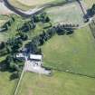
The wasted remains of an unusually small Roman fort occupy the summit of a narrow gravel plateau on the right bank of the River Clyde. The existence of a fort in this neighbourhood, one day's march N of the fort at Trassiesholm, was suspected by General Roy, but it was not until 1938 that Professor J K S St Joseph discovered its precise location; further excavation, undertaken by the Commission in 1961-6, revealed much of the layout of its defences and gave some indications of its internal plan during three successive periods of occupation.
Situated at the junction of the Roman roads leading from Annandale (No. 263) with Nithsdale (No.265), and guarding the bridge or ford by which the latter crossed the river, the fort commanded extensive views along the narrow valley of the River Clyde to the SE and W, but to the N, where the road ascended the steep SE face of Castle Hill by a skilfully engineered zig-zag route, its view was more restricted. The site itself affords moderately strong natural protection, the S side of the plateau, which faces the Clyde being most steeply scarped, probably as a result of riverine erosion in the distant past, the others sloping gently down to low-lying ground, which pparticularly on the E and W, may have been poorly drained in Roman times.
Topographical considerations apart, the fort was also admirably sited to watch over and control the local native population.
THE FLAVIAN FORT measured approximately 116 m by 69m over a rampart built mainly of turf and earth, and about 5.5m in thickness. Two ditches, each 3.0 m and 1.1 m in average width and depth respectively, lay immediately outside the rampart on all four sides, additional protection being provided by an outlying ditch of slighter proportions, which was traced only on the N and W, but which probably also covered the E front. The position of the two entrances located during excavation, those on the S and W, suggested that in its earliest phase the fort faced S, the via principalis, contrary to common practice in forts of such an elongated plan, running parallel to the long axis; there was, in consequence, apparently no retentura and very probably no porta decumana. At the W gate, the porta principalis dextra, where only a little detailed examination was possible, it appeared likely that there had been a single entrance-passage flanked on either side by a square timber tower.
The internal buildings, which were all of timber, seemed to have been carefully dismantled at the end of the occupation, the main wooden members probably being saved for re-use elsewhere. The principia, or headquarters-building (1), the smallest example of its type yet discovered in the Roman empire measured only 9.8m by 9.1m, with a verandah 2.4m deep on its S side; it comprised an outer courtyard, flanked on three sides by open porticoes, and a single room running the full width of the building at the rear. To the W lay a small granary (2), of orthodox design, which probably had a verandah or covered loading-bay on the S. The disposition of the remaining buildings inside the fort was not absolutely clear, but it seems probable that to the E of the principia lay either the commandant's residence or even another granary (3), and beyond that, built end-on to the via principalis, a pair of buildings measuring about 30.5m by 8.2m, presumably barracks (4-5); there was a corresponding pair to the W of building 2 (6-7). The praetentura contained space for only two buildings (8-9), each similar in width to the presumed barracks but almost 46m in length.
Such a layout invites comparison with that of the forts at Hod Hill and Valkenburg , both of which were first constructed before the middle of the 1st century AD. At Crawford, however, there can be no doubt, from the evidence of relics recovered during excavation, that the fort was built early in the campaigns of Agricola, possibly c AD 80, and abandoned shortly after his recall. A bronze coin of the emperor Domitian dated to AD 86 was found in mint condition in a demolition layer overlying the S intervallum street; identical coins were found in terminal deposits at the Flavian fortress of Inchtuthil, at Newstead, and several other forts throughout N Britain believed to have been abandoned at the end of the first Flavian period of occupation.
In the absence of inscriptions the identity of the earliest garrison at Crawford must remain uncertain, but the area occupied by the fort, about 0.8 ha (2.0 acres) together with the little that is known about the internal buildings, indicates that it could not have been of quingenary strength. Furthermore the diminutive size of the principia clearly precludes the possibility that some small independent unit, such as a numerus, was stationed here. It has therefore been suggested that the garrison was a vexillation of auxiliary troops possibly comprising the mounted component of a cohors quingenaria equitata, for the accommodation of whose troopers the four bar-rack-like structures to the N of the via principalis would have been particularly appropriate.
THE EARLY ANTONINE FORT. In the second period of occupation, although the external dimensions remained virtually the same, the internal layout was drastically altered, the street plan being turned through an angle of 90, so that the fort now faced, E and the via principalis ran parallel with the short axis. The front of the Agricolan rampart was cut away on all sides to allow the construction of a new outer revetment of clay resting on a foundation-layer of stone or gravel. Both the innermost and the outermost ditch were recut, the former to approximately the same size as before, the latter being appreciably wider and, on the W front, diverging slightly from its previous course. The inter- mediate ditch, however, was completely replaced by a much larger one, measuring in places as much as 6.1 m wide and 1.8 m deep; on the S half of the W front it possessed a central comb or midrib. The positions of the gates could be determined by reference to the street plan but none was actually examined.
The internal buildings, being constructed partly or wholly of stone, must have been used as a convenient quarry by the builders of the medieval castle that lies in ruins immediately to the S of the fort, but excavation suggested that, at least in the case of the principia (1), much of the destruction was due to deliberate demolition at the end of the third period. The principia whose walls rested on foundation trenches packed with clay and cobbles, was of normal size and orthodox plan, comprising a gravelled outer courtyard flanked on the S, and probably on the N, by a timber portico, a cross-hall containing traces of what may have been a podium for a statue, and a suite of five rooms at the rear; denarii of the emperors Trajan and Hadrian found on the floor of the central room, the sacellum, may have come from the garrison money-chest. To the S of the principia, but set back 5.1m from the via principalis, lay a granary (2), a building of similarly robust construction, but even more seriously mutilated. The commandant's house, presumably lying immediately to the N of the principia, was not examined, but the space available for its construction was severely restricted, which suggests that it may have been of unusual design, perhaps comparable with the earlier praetoria at Cadder (NS67SW 16). Apart from building 9, possibly a smithy or workshop which was constructed entirely of stone, the remaining internal structures had apparently been of timber, clad with wattle-and-daub panels; however, the lower part of the wooden framework had been incorporated in dwarf-walls of stone. Four such buildings (3-6), each measuring 19.8m by 8.5m externally, were discovered in the retentura, and there was room for six more, including the two actually located (7-8) in the praetentura.
The buildings were about half the normal size of auxiliary barracks, so that, assuming there were ten such buildings, the garrison could theoretically have been either half a cohors milliaria peditata or half a cohors quingenaria equitata, depending on, whether the buildings were all barracks or included stables. On balance, however, it is more probable that in the first Antonine period the garrison was a vexillation of a cohors quingenaria equitata, the rest of the regiment being out-stationed, presumbaly on a rota basis, in such fortlets and watch-towers as Redshaw Burn (NT01SW 2) and Beattock Summit (NS91NE 11) possibly even as far S as Barburgh Mill, (NX98NW 2).
THE LATER ANTONINE FORT. After only the briefest of intervals the fort was again subjected to thoroughgoing alterations, although its orientation remained unchanged. The fortlet system was not revived, and it must be assumed that the fort operated as an independent strong-point. The inner pair of ditches, which had contained virtually no silt at all, were deliberately filled, particular care being taken on the N and S where the large ditch was packed solid either with layers of newly-cut turves or with turf blocks from the slighted Antonine I rampart heaped upon a bottoming of boulders. This was done because the fort was now increased in width and a stable foundation had to be prepared for the new turf-and-earth rampart which was set forward an average distance of 11m on the N and S sides, thus overlying the earlier ditch-system. On the E and W the second-period rampart was given a fresh outer facing of clay and turf, kerbed or underpinned with stone, and its thickness was increased to about 6 m, roughly the same as that of the new rampart on the other two sides. In consequence the fort now measured 91 m by 117 m over the rampart and occupied an area of approximately 1.1 ha (2.7 acres). The former outermost ditch thus because the inner one, without any need for recutting, because the interval of abandonment had been so short; to it was added a new outer ditch, 4.3m in average
width, lying near the foot of the slope on the N and W separated from the inner by a space varying between 12m and 26m, which on the N front appears to have been traversed by a gully and a series of shallow obstacle-pits, similar to the lilia at Rough Castle.(NS87NW 6).
Limited excavation at the N gate indicated that its entrance-passage had been 3.0m wide, and that at the end of the occupation the timber uprights on either side had been dug out, the post hole pits then being deliberatley packed with stones and occupation debris.
The principal internal buildings (1 and 2) were brought back into commission with little or no structural alteration. It may have been now that the floor of the principia cross-hall was resurfaced and the portico in its courtyard rebuilt, but it is impossible to be certain precisely when this took place; nor is it known if the opportunity was taken to construct a more commodious praetorium or even an additional granary, for both of which there was now ample room. Certain changes were, however, effected: building 9, which apparently continued to be used for metal-working, was rebuilt on the same plan but with a reduced wall- thickness, while buildings 3-8, and presumaly the other buildings in the praetentura, were uniformly increased in length to 25.0m.
Such an increase may be taken to indicate that the fort was now occupied by a garrison of a different character, requiring more spacious quarters - possibly a vexillation of a cohors milliaria.
Although it is reasonably clear that the second Antonine fort was carefully dismantled, as a matter of deliberate policy rather than as a result of assault by hostile tribesmen, it is no longer possible to claim that the discovery of Castor-ware sherds in the last-period barracks implies a final abandonment after AD 170 rather than about AD 163.
W Roy 1793; J K St Joseph 1952; G S Maxwell 1974; RCAHMS 1978, visited 1971.
When visited in 1959, only an elevated area measuring some 92.0m E-W by 73.0m could be traced. This almost flat-topped plateau had roughly rounded angles which defined the course of the inner rampart. A broad, low mound lay some 60.0m to the W and 40.0m N of the edge of the plateau, some 20 ft below it. It was spread to about 16.0m. There was
a vague suggestion of an intermediate bank on the gentle slope of the plateau.
Visited by OS (WDJ) 31 July 1959
In an almost level topped plateau under pasture the course of the N and partof the W ramparts are visible as a low spread scarp. This is 0.3m maximum height, with three, vague, though clearly artificial rounded angles. These features when planned form a largely coherent and regular shape 104m by 74m which is consistent with the RCAHMS excavation plan. Surveyed at 1:2500.
Visited by OS (JRL) 16 August 1978.

