
Pricing Change
New pricing for orders of material from this site will come into place shortly. Charges for supply of digital images, digitisation on demand, prints and licensing will be altered.
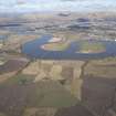
Alloa, Forth Rail Bridge


Railway Bridge (19th Century)
Site Name Alloa, Forth Rail Bridge
Classification Railway Bridge (19th Century)
Alternative Name(s) River Forth; Forth Railway Bridge; Alloa Railway Bridge; Alloa Swing Bridge; Throsk; Rhind
Canmore ID 80302
Site Number NS89SE 79
NGR NS 8627 9156
NGR Description NS 8627 9156 to NS 8616 9110
Datum OSGB36 - NGR
Permalink http://canmore.org.uk/site/80302


- Council Clackmannan
- Parish Alloa
- Former Region Central
- Former District Clackmannan
- Former County Clackmannanshire
NS89SE 79 8627 9156 to 8616 9110
Alloa Bridge (Dismantled) [NAT]
OS 1:10,000 map, 1991.
Not to be confused with (Queensferry Narrows) Forth Railway Bridge (NT 1390 7790 to 1315 8082), for which see NT17NW 70.
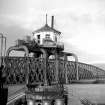
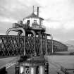
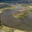
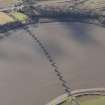
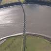
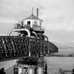
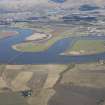
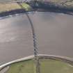
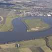
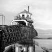
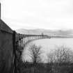
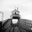
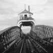
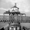
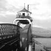
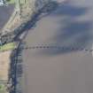
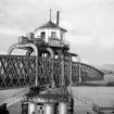
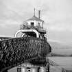
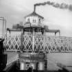
The Alloa Railway built a 1600 ft (488m) swing bridge across the river. The North British Railway had running powers over this route.
The line between Alloa (West Junction) and Larbert (Alloa Junction) was closed to regular passenger traffic on 29 January 1968, the bridge being subsequently demolished.
J Thomas 1971; G Daniels and L Dench 1980.
This bridge (which was usually known as Alloa Bridge) was based upon the branch line constructed by the Scottish Central Rly. to the ferry terminal at South Alloa from the main Stirling line at Alloa Junction (NS 852 860), which was intended to form part of the proposed Glasgow and Dundee Junction Rly.
Regular passenger services across the bridge were withdrawn on 29 January 1968, goods services (of which there were numerous) ending in May of the same year. Demolition started nine months later, and only the piers now remain.
W S Bruce 1980.
This bridge formerly carried the Larbert-Airth-Alloa branch of the Caledonian Rly. across the River Forth, between the parishes of Airth (county of Clackmannanshire, subsequently Clackmannan District of Central Region) and St Ninians (county of Stirlingshire, subsequently Stirling District of Central Region).
Information from RCAHMS (RJCM), 12 November 1996.
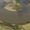
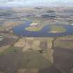
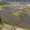
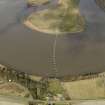
The remains of a rail bridge spans the Forth, c 400m west of Throsk at its south end and the Rhind on the north side. The bridge has been dismantled and only its vertical supports remain. The metal parts of the bridge supports are exposed to continuous weathering and are corroding. The rail bridge was in use as such in 1946. B72 4258-9 15/5/46.
Site recorded by GUARD during the Coastal Assessment Survey for Historic Scotland, 'The Firth of Forth from Dunbar to the Coast of Fife' 22nd February 1996.
Field Visit (22 February 1996)
The remains of a rail bridge spans the Forth, c 400m west of Throsk at its south end and the Rhind on the north side. The bridge has been dismantled and only its vertical supports remain. The metal parts of the bridge supports are exposed to continuous weathering and are corroding. The rail bridge was in use as such in 1946. B72 4258-9 15/5/46.
Site recorded by GUARD during the Coastal Assessment Survey for Historic Scotland, 'The Firth of Forth from Dunbar to the Coast of Fife' 22nd February 1996.
Publication Account (2007)
In 1885 the Alloa Railway crossed the Forth five miles upstream by means of a single track 1615 ft long viaduct
with 15 wrought-iron lattice bow-girder spans of 68 ft, two of 80 ft, one of 100 ft and two opening spans of 60 ft
clear. It was designed by Crouch & Hogg. The contractorswere Watt & Wilson and the ironwork was executed by P. & W. MacLellan. The bridge was demolished in 1971.
R Paxton and J Shipway 2007
Reproduced from 'Civil Engineering heritage: Scotland - Lowlands and Borders' with kind permission from Thomas Telford Publishers.

