
Dalnair


Temporary Camp (Roman)
Site Name Dalnair
Classification Temporary Camp (Roman)
Alternative Name(s) Antonine Wall
Canmore ID 46806
Site Number NS87NW 9
NGR NS 81040 79000
Datum OSGB36 - NGR
Permalink http://canmore.org.uk/site/46806


- Council Falkirk
- Parish Falkirk
- Former Region Central
- Former District Falkirk
- Former County Stirlingshire
NS87NW 9 81040 79000
See also NS87NW 10.
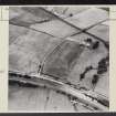
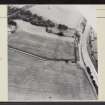
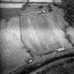
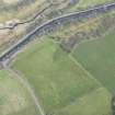
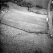
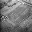
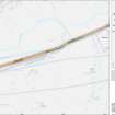
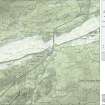
NS 810 790. A Roman temporary camp is situated in the field between Dalnair farmhouse and Cheapside. No traces remain on the ground but the NW side of the camp, including an entrance with a tutulus, the N and W rounded angles, and stretches of the NE and SW sides are visible on air photographs. The camp measures about 400' in width, but its length cannot yet be determined.
RCAHMS 1963, visited 1957
No further information. The field is regularly cultivated.
Site surveyed at 1:2500.
Visited by OS (MJF) 30 April 1980
Further aerial photographs taken by the RCAHMS in 1980.
(Undated) information in NMRS.
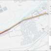
The length of the Antonine Wall (NS87NW 32.00) between Dalnair and Seabegs Wood [NS 8095 7908 to NS 8118 7922] has been scheduled, together with Dalnair temporary camp (NS87NW 9) and Seabegs fortlet (NS87NW 10).
Information from Historic Scotland, scheduling document dated 10 February 2005.
Aerial Photography (1 August 1957)
Field Visit (10 December 1957)
NS87NW (unnoted) 810 790
Roman Temporary Camp, Dalnair (Site).
This camp is situated in the field between Dalnair farmhouse and the cottages marked as Cheapside on the O.S. map, at a distance of half a mile SW. of Seabegs Place and 70 yds. S. of the Antonine Wall. No traces remain on the ground, but the NW. side of the camp, including an entrance with a tutulus, the N. and W. rounded angles, and stretches of the SW. and NE. sides were observed from the air and photographed by Dr. St. Joseph in 1957 (1). The camp measures about 400 ft. in width, but its length cannot yet be determined as the. SE. side does not appear on the photographs: it may have been comparable in size to those at Tollpark, Milnquarter and Camel on.
RCAHMS 1963, visited 10 December 1957
(1) Nos. VY 17 and WB 82 in the C.U.C.A.P.
Aerial Photography (30 July 1957)
Aerial Photography (31 July 1957)
Note (1978)
Dalnair NS 810 790 NS87NW 9
Listed as Temporary Camp.
RCAHMS 1978
(RCAHMS 1963, p. 107, No. 120)
Field Visit (30 April 1980)
No further information. The field is regularly cultivated.
Site surveyed at 1:2500.
Visited by OS (MJF) 30 April 1980
Ground Survey (30 April 1980)
No further information. The field is regularly cultivated.
Site surveyed at 1:2500.
Visited by OS (MJF) 30 April 1980
Aerial Photography (1980)
Further aerial photographs taken by the RCAHMS in 1980.
(Undated) information in NMRS.
Aerial Photographic Transcription (20 July 1998)
An aerial transcription was produced from oblique aerial photographs. Information from Historic Environment Scotland (BM) 31 March 2017.
Watching Brief (February 2007)
Headland Archaeology Ltd was commissioned by Scottish Water to conduct an archaeological watching brief near Allandale, Falkirk. Scottish Water are conducting remedial works on the mains water supply in the area around Allandale. Part of the works impacted on existing services located in close proximity to the line of the Antonine Wall (ditch, bank & military way), a Scheduled Ancient Monument. As a section of the works impacted within a Scheduled area (SAM 7742), Scheduled Monument Consent from Historic Scotland was necessary and groundbreaking works were to be monitored in the event of the uncovering of significant archaeological remains. The excavation of six test-pits within the area of the works (5 within the Scheduled area and 2 outwith) confirmed the presence of existing water mains pipes. In all cases the works impacted upon the infilled service trenches with minimal peripheral impact on the natural subsoil. The works did not encounter any archaeological remains, other than vestiges of land drainage dating to the agricultural improvements of the recent past.
Publication Account (2008)
A 1:25000 scale map of the Antonine Wall was published by RCAHMS in 2008. The map shows the course of the Antonine Wall on a modern map base, including areas where the Wall is in public ownership or care and can be visited. The data had been collated as part of the project to prepare maps for the World Heritage Site nomination bid.
Publication Account (17 December 2011)
The camp near Dalnair farm was first recorded from the air by St Joseph in July 1957 (RCAHMS 1963: 107), lying less than 100m to the south of the Antonine Wall, some 200m south-west of the fortlet at Seabegs Wood. It is situated on ground that slopes gently down to the west to the Skipperton Burn, a tributary of the Bonny Water. The camp of Milnquarter lies some 1.5km to the east, and the fort of Castlecary just over 2km to the west.
The whole of the NNW side of the camp, about 145m, has been recorded through cropmarks from the air, along with the rounded corner and a short length of the WSW side and the corner and up to 75m of the ENE side. No information on the likely position of the SSE side has been recorded, although if the camp has similar dimensions to nearby Milnquarter then part of this side could lie under Dalnair farmhouse. There is an entrance gap in the centre of the NNW side, protected by a titulus. The camp probably faced NNW, towards the line of the Wall.
R H Jones

