
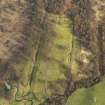
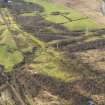
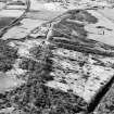
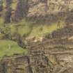
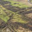
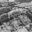
Rough Castle


Field System (Period Unassigned)
Site Name Rough Castle
Classification Field System (Period Unassigned)
Canmore ID 46790
Site Number NS87NW 12
NGR NS 8457 7979
Datum OSGB36 - NGR
Permalink http://canmore.org.uk/site/46790


- Council Falkirk
- Parish Falkirk
- Former Region Central
- Former District Falkirk
- Former County Stirlingshire
NS87NW 12 846 798
See also NS87NW 6.
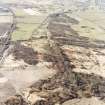
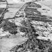
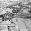
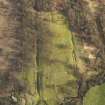
Following survey by the RCAHMS of a group of pre-improvement small rectangular fields lying immediately SE of the Roman fort, the banks and ditches which outline the fields were sectioned for dating and environmental evidence. A road, aligned on the E side of the fort and cognate with the field system was discovered.
J Barber 1982
(Schedule no. 8244). The Antonine Wall from Rough Castle to Lime Road, Tamfourhill, Falkirk isscheduled, together with the Rough Castle Roman fort and multi-period field-system.
Information from Historic Scotland, scheduling document dated 4 March 2005.
Measured Survey (1981)
RCAHMS surveyed the field system at Rough Castle by self-reducing alidade and plane-table in 1981 at scale of 1:1000. This survey was used as the basis of the plan of the field system published in 1995 (Mate 1995, 496 Illus 2).

