
Tamfourhill - Callendar Park, Antonine Wall, Military Way


Frontier Defence (Roman), Roman Road (Roman)
Site Name Tamfourhill - Callendar Park, Antonine Wall, Military Way
Classification Frontier Defence (Roman), Roman Road (Roman)
Alternative Name(s) Rough Castle
Canmore ID 227745
Site Number NS87NE 57.01
NGR NS 8510 7980
NGR Description From NS 8500 7984 to NS 8527 7974
Datum OSGB36 - NGR
Permalink http://canmore.org.uk/site/227745


- Council Falkirk
- Parish Falkirk
- Former Region Central
- Former District Falkirk
- Former County Stirlingshire
NS87NE 57.01 from NS 8500 9784 to 8527 7974
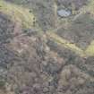
NS 8500 7984 to NS 8527 7974 Military Way very visible between Rough Castle and Camelon about 2 chains from Wall, running parallel to it (Horsley 1732).
The Military Way is generally well preserved in close woodland as a stony agger [causeway] c. 5.5m wide and 0.4m high. East of Bonnyhill Rd there is no trace in an area now being developed. Inspection of building site proved negative and no finds of metalling are reported. Published survey correct.
NS c.8550 7979 to NS c.8600 7984 Modern road may lie over Military Way (Robertson 1979).
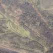
NS 896 795 Further work (Keppie and Walker 1981) confirmed the alignment of the Wall within the policies of the former College of Education. The Military Way appeared at one point to incorporate a number of post-settings, but their purpose could not be established (Keppie and Walker 1982).
Information from OS 1980
J Horsley 1732; L J F Keppie and J J Walker 1981, 1982; A S Robertson 1979
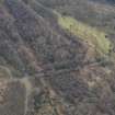
NS 853 798 Small-scale excavation in advance of borehole-drilling c.500m E of Rough Castle fort (NS87NW 6) (a) N of the Antonine Ditch and (b) S of the Military Way revealed no evidence of activity in the Roman period.
L J F Keppie 1998.
Small scale excavation at Tamfourhill (NS 855 797) in advance of works associated with the refurbishment of the Union Canal and its extension to the W to facilitate the renewal of its junction with the Forth and Clyde Canal at the 'Falkirk Wheel' development-site revealed:
NS 8523 7975 Cobbling possibly belonging to the Military Way
NS 8595 7955 The titulus defending a gateway on the N side of the Tamfourhill temporary camp (NS87NE 13)
NS 8583 7959 A cobble surface of ill-defined date in the camp interior
NS 8571 7984 The N edge of the Antonine Ditch (NS87NE 57.00) in an area already much disturbed
L J F Keppie 2001.
NS 852 797 A series of excavations and watching briefs took place within the scheduled area of the Antonine Wall and Rough Castle fort between 1995 and 2001, close to the point where Bonnyhill Road crosses over the Glasgow-Edinburgh Railway. Excavations and watching briefs produced no remains of archaeological significance, despite the proximity of the works to the putative line of the Military Way.
J W Gooder 2002
A Dunwell, G Bailey, A Leslie, A Smith 2002.
Borehole Survey (1 October 1997)
Report (No. 368) on archaeological excavations at the Antonine Wall, near Rough Castle carried out on behalf of Dames and Moore
Watching Brief (2 July 1999 - 7 July 1999)
NS87NE 152 8523 7980
Watching brief carried out during the laying of electricity cables and erection of overhead power lines within the scheduled area of the Antonine Wall Roman frontier works.
Sponsor: HS; Scottish Power plc
Information from CFA 1999 (MS/726/158)
Test Pit Survey (March 2000)
At NS 8525 7974 and at NS 8525 7976 In March 2000, four test-pits, each 4sq m in area, were excavated in woodland to the S of the Antonine Wall and to the N of Bonnyhill Road. Test-pit 2 and 4 were archaeologically sterile or disturbed. Test-pit 3 lay roughly 40m S of the Rampart. Its excavation revealed a stone-layer and extended across the entire test-pit. Test-pit 1 revealed a discontinuous spread of stones of similar size and form to those in Test-pit 3. However, the feature is too ephemeral to relate to the rampart base of an unknown mile fortlet, that has been proposed for this area (Keppie and Walker 1981).
J W Gooder 2002
A Dunwell, G Bailey, A Leslie, A Smith 2002; L J F Keppie and JJ Walker 1981.

