|
Manuscripts |
MS 726/118 |
Records of CFA Archaeology Ltd, archaeologists, Musselburgh, East Lothian, Scotland |
Report (No. 368) on archaeological excavations at the Antonine Wall, near Rough Castle carried out on behalf of Dames and Moore |
12/1997 |
Item Level |
|
|
Photographs and Off-line Digital Images |
DC 47351/5 |
Records of the Ordnance Survey, Southampton, Hampshire, England |
Ordnance Survey 6-inch to the mile Provisional Edition, revision of 1944 with additions in 1946.
Additional annotations by Ordnance Survey for the Antonine Wall map covering the parish of Falkirk with Callendar Wood. |
c. 1946 |
Item Level |
|
|
Photographs and Off-line Digital Images |
DC 47351/6 |
Records of the Ordnance Survey, Southampton, Hampshire, England |
Ordnance Survey 6-inch to the mile Provisional Edition, revision of 1943-44 with additions in 1946.
Additional annotations by Ordnance Survey for the Antonine Wall map covering the parish of Falkirk (W) with Rough Castle. |
c. 1946 |
Item Level |
|
 |
On-line Digital Images |
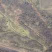
DP 249507 |
Historic Environment Scotland |
Oblique aerial view. |
24/3/2017 |
Item Level |
|
 |
On-line Digital Images |
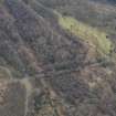
DP 249511 |
Historic Environment Scotland |
Oblique aerial view. |
24/3/2017 |
Item Level |
|
 |
On-line Digital Images |
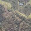
DP 249512 |
Historic Environment Scotland |
Oblique aerial view. |
24/3/2017 |
Item Level |
|
 |
On-line Digital Images |
SC 1970706 |
Records of Historic Scotland, Edinburgh, Scotland |
Antonine Wall 1:25000 broadsheet map |
2008 |
Item Level |
|
|
Digital Files (Non-image) |
GV 008531 |
Records of Historic Scotland, Edinburgh, Scotland |
Map showing the Antonine Wall, the World Heritage Site area, the areas of the World Heritage Site in public ownership or care, the Buffer Zone and the Council boundaries. Created for the World Heritage Site nomination - Management plan. |
2006 |
Item Level |
|
 |
On-line Digital Images |
SC 2170806 |
Records of Historic Scotland, Edinburgh, Scotland |
Map showing the Antonine Wall, the World Heritage Site area, the areas of the World Heritage Site in public ownership or care, the Buffer Zone and the Council boundaries. Created for the World Heritage Site nomination - Management plan. |
2006 |
Item Level |
|
|
All Other |
551 30/13/10 |
Records of CFA Archaeology Ltd, archaeologists, Musselburgh, East Lothian, Scotland |
Archive of Excavation on the Antoinine Wall, Near Rough Castle |
c. 10/1997 |
Sub-Group Level |
|


