
Pricing Change
New pricing for orders of material from this site will come into place shortly. Charges for supply of digital images, digitisation on demand, prints and licensing will be altered.
Kirkfieldbank Bridge


Road Bridge (20th Century)
Site Name Kirkfieldbank Bridge
Classification Road Bridge (20th Century)
Alternative Name(s) Lanark, Kirkfieldbank Road, New Bridge; River Clyde
Canmore ID 199699
Site Number NS84SE 136
NGR NS 86831 43964
Datum OSGB36 - NGR
Permalink http://canmore.org.uk/site/199699


- Council South Lanarkshire
- Parish Lesmahagow
- Former Region Strathclyde
- Former District Clydesdale
- Former County Lanarkshire
NS84SE 136 86831 43964
Location cited as NS 86804 43945.
For (predecessor and superceded) Clydesholm Bridge (adjacent to SE), see NS84SE 4.
Kirklandfield Bridge [NAT]
OS 1:10,000 map, 1985.
NMRS REFERENCE
Architect: John Lochore 1695 produced draught of new bridge.
Kirkfieldbank Bridge crosses the parishes of Lesmahagow and Lanark.
(Undated) information in NMRS.
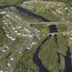
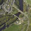
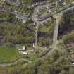
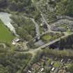
This bridge carries the present line of the A72 public road over the River Clyde to the W of Lanark (NS84SE 75). The river here forms the boundary between the parishes of Lanark (to the NE) and Lesmahagow (to the SW).
The location assigned to this record defines the centre of the structure; the available map evidence indicates that it extends from NS c. 86799 43939 to NS c. 86853 43980.
Information from RCAHMS (RJCM), 24 February 2006.
Desk Based Assessment (3 July 2017)
This single arch bridge carries the A72 across the River Clyde, connecting the village of Kirkfieldbank to the west with Lanark to the east. It opened in 1959, relieving the 17th century Clydesholm Bridge (NS84SE 4), 50m upstream, of much of its traffic.
Information from HES Survey and Recording (AMcC) 3 July 2017.

