
Scheduled Maintenance
Please be advised that this website will undergo scheduled maintenance on the following dates: •
Tuesday 3rd December 11:00-15:00
During these times, some services may be temporarily unavailable. We apologise for any inconvenience this may cause.
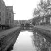
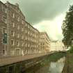
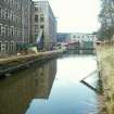
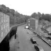
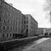
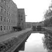
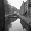
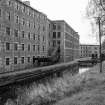
New Lanark, Lade


Lade (18th Century)
Site Name New Lanark, Lade
Classification Lade (18th Century)
Alternative Name(s) New Lanark Mills; New Lanark Industrial Village; Mill Lead; Mill Race; River Clyde
Canmore ID 178746
Site Number NS84SE 125
NGR NS 88108 42469
NGR Description NS 87989 42557 to NS 88125 42323
Datum OSGB36 - NGR
Permalink http://canmore.org.uk/site/178746


- Council South Lanarkshire
- Parish Lanark
- Former Region Strathclyde
- Former District Clydesdale
- Former County Lanarkshire
NS84SE 125 88108 42469 (NS 87989 42557 to NS 88125 42323)
For New Lanark, mills and industrial village (centred NS 88025 42614), see NS84SE 58.00.

