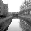
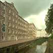
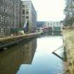
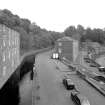
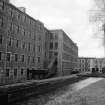
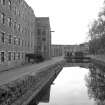
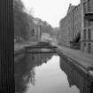
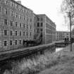
Accessibility

Font Size

100% 150% 200%

Background Colour

Default Contrast
Close Reset

New Lanark, Lade

Lade (18th Century)

Site Name New Lanark, Lade

Classification Lade (18th Century)

Alternative Name(s) New Lanark Mills; New Lanark Industrial Village; Mill Lead; Mill Race; River Clyde

Canmore ID 178746

Site Number NS84SE 125

NGR NS 88108 42469

NGR Description NS 87989 42557 to NS 88125 42323

Datum OSGB36 - NGR

Permalink http://canmore.org.uk/site/178746

Ordnance Survey licence number AC0000807262. All rights reserved.
Canmore Disclaimer. © Bluesky International Limited 2025. Public Sector Viewing Terms

Toggle Aerial | View on large map

Digital Images

New Lanark, Lade
View N along southernmost 'leg' of lade; Caithness Row in distance
New Lanark, Lade
View N along southernmost 'leg' of lade; Caithness Row in distanceView looking NW along lade with Mill Number 1 in background and part of Mill Number 2 and Mill Number 3 on leftView from N of lade emerging from tunnel at S end of the villageNew Lanark: view from E of lade as it passes in front of Mill No. 3, with Mills No. 2 and 1 in the distanceView from E of lade and sluices in front of Mill No. 2 (left) and Mill No. 1 (right)View from SE along lade, with Mills No. 3 and 2 on the left, and Mill No.1 in the background.
Copy of 35 mm colour transparency.View from NE of lade and sluices in front of Mill No. 2 (left) and Mill No. 1 (right)View from N of tailrace emerging into the River Clyde from beneath the 'Water Houses', with Mill No. 1 visible (left)Elevated view from NW of NW end of School, with River Clyde and Dye Works and Engineers' Workshop buildings in the background, and the SW side of the Institute partially visible (left), with the lade in the foregroundView from W of lade, with Caithness Row in the backgroundView from E of lade as it passes in front of Mill No. 3, with Mills No. 2 and 1 in the distanceNew Lanark
View from NE of Mill Nos 2 (background) and 3 (foreground), lade in foregroundView looking NW along lade with Mill Number 1 in background and part of Mill Number 2 and Mill Number 3 on leftView from NNE showing N entrance to lade tunnel with part of lade in foregroundView from SE of lade as it passes in front of Mills No. 3, 2 and 1View from E of lade as it passes in front of Mill No. 3, with Mills No. 2 and 1 in the distanceNew Lanark, Lade
View from SE along main stretch of lade, Mill No.1 in backgroundNew Lanark: view looking SE along lade with Mill Number 3 in background and part of Mill Number 2 on rightView from E showing NNE and ESE fronts of Mill Number 2 with part of Mill Number 3 on left, Mill Number 1 in background and lade in foreground

Administrative Areas

  • Council South Lanarkshire
  • Parish Lanark
  • Former Region Strathclyde
  • Former District Clydesdale
  • Former County Lanarkshire

Archaeology Notes

NS84SE 125 88108 42469 (NS 87989 42557 to NS 88125 42323)

For New Lanark, mills and industrial village (centred NS 88025 42614), see NS84SE 58.00.

References

MyCanmore Image Contributions


Contribute an Image

MyCanmore Text Contributions