
Stirling, King's Knot


Earthwork (Period Unknown), Garden (17th Century)
Site Name Stirling, King's Knot
Classification Earthwork (Period Unknown), Garden (17th Century)
Alternative Name(s) Royal Gardens
Canmore ID 46256
Site Number NS79SE 7
NGR NS 78896 93646
NGR Description Centred on NS 78896 93646
Datum OSGB36 - NGR
Permalink http://canmore.org.uk/site/46256


First 100 images shown. See the Collections panel (below) for a link to all digital images.
- Council Stirling
- Parish Stirling
- Former Region Central
- Former District Stirling
- Former County Stirlingshire
NS79SE 7 centred 78896 93646
Fore adjacent Stirling Castle, see NS79SE 6.00
(NS 7855 9318) King's Park (NAT)
(NS 7889 9364) King's Knot (NR)
OS 6" map (1958)
The King's Park, which lies immediately SW of the Castle Rock (for which see NS79SE 6), appears to have been Crown property since at least the end of the 12th century, when William the Lion began to enlarge the area of the original park by taking in more ground to the S, the earlier and later enclosures becoming known as the Old Park and the New Park. These "parks" were primarily hunting grounds, and references to the King's deer are found as late as the 17th century.
From about the beginning of the 16th century onwards, the NE corner of the Old Park seems to have been set aside as a garden. An extensive system of alterations and reconstructions was carried out about 1627-8; it is to this period that the extant remains have their origin. Today, there may be seen a parterre, to the SE of which is an octagonal, stepped mound known as the Knot. The mound, a characteristic feature of gardens of the 16th and 17th centuries, is 9' high and 22' across the top. It stands within a double-ditched enclosure measuring 420' x 425' over all. The S angle and part of SW side have been encroached upon by the Dumbarton road. No doubt the outlines of the walks and of the Knot became indistinct after the gardens fell out of use (before the beginning of the 18th century) for a "thorough restoration and renewal" was carried out in 1867. A comparison of the site as it is today with an 18th century War Office plan in the Public Record Office, London (WO 78/1562), suggests that in the course of restoration the "mount" was considerably altered, while it also seems possible that the orientation of the entire enclosure was slightly changed.
On the SE side of the King's Knot, a ditch can be seen running from the E corner of the Park to the Dumbarton road, a distance of about 140 yds. It measures 25' - 30' in width, and the E half is still as much as 5' deep in places although the W half has been almost completely filled in. According to the 6" OS map, there was a bank on the N side of the
ditch, but this has now been obliterated. The 18th century map referred to earlier shows that the ditch run roughly parallel with the S side of the Knot, before the axis of the latter was altered, and returned sharply northwards at some point underneath the present Dumbarton road to cover part of the W side of the Knot. The sharpness of the corner is sufficient to disprove the theory that this earthwork represents the remains of a Roman fort (see NS79SE 10) and it seems likely that it is an early boundary designed to keep deer and livestock out of the Royal garden. The present boundary wall of the Park on the NE is built on the line of a similar bank and ditch.
RCAHMS 1963, visited 1959.
The King's Park and King's Knot are as described by RCAHMS.
The ditch on the SW of King's Knot is probably a boundary work as suggested.
Visited by OS(JP) 6 December 1973.
The remains of the formal garden known as The King's Knot, lying S of Stirling Castle, has a ditch 8.23m wide running obliquely acrossthe E approaches to the raised 'knot'. This ditch is alien to the rectilinear style of the garden, and it was suggested by Crawford that it might be Roman. Excavation in the playing fields to the S, across the road, proved that this ditch does continue. In this particulary wet area the ditch sides had collapsed at least twice, trapping silts containing vegetable matter, which was sampled. Nearby to the W, an extensive series of test pits failed to find the Roman road on the next accessible forward projection from the last reported location in King's Park. It may be that this deviation from an apparently suitable line, leading to two fordable Forth crossings, could have a link with the ditch.
D J Milne 1975
White (R White 1871), quoting from the Chamberlain's Accounts of Stirling, states: "In 1263 the sheriff of Stirling was employed in repairing the ancient park, and in constructing a new park there for Alexander III...Twenty years later there was an allowance for... four hundred perches (2200 yds) of palisade round the new park..."
This is the earliest record of such a fence in Scotland. Documentary evidence reveals that Stirling old park which lay to the W of the castle was built by William I. This old park fell out of use but was renovated by James IV in the late 15th and early 16th centuries. Some traces of this latter park can perhaps be detected on the ground; it was probably smaller in area than William I's park. The bounds of William I's park may have followed the line of the parish boundary marked today by a fence and ditch, since it forms a much more natural line for the park pale to the N of the present park. The bounds of the present park would then belong to James IV's renovation and it is probably traces of this pale which were once visible on the NE boundary of the King's Park, and which are still visible to the SE of the King's Knot. The boundaries of the new park of Stirling, built by Alexander III and repaired in 1288 x 1290 have been traced (T Miller 1922), although no remains of this pale survive.
M L Anderson 1967; J M Gilbert 1979.
King's Knot: Photographed by the RCAHM in 1980.
RCAHMS AP Catalogue 1980.
Field Visit (September 1978)
King's Knot NS 789 936 NS79SE 7
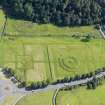
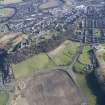
Air photography has revealed three concentric ditches of an earthwork underlying the formal gardens of the King's Knot. The earthwork measures about 100m in breadth over all, and although the N side has not yet been located, it is probably trapezoidal on plan. The existing remains of the King's Knot may originate from the reconstruction of the Royal gardens about 1627-8, and the ditch on the SE side, which measures up to 10m broad, is probably all that survives of an early boundary to the gardens.
RCAHMS 1979, visited September 1978
(RCAHMS 1963, pp. 219-20, no. 192; DES, 1975, 53-4)
Publication Account (1985)
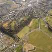
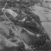
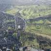
The King's Knot forms the most prominent part of an elaborate landscaped garden laid out in 1628-9 as a part of a programme of alterations carried out at Stirling Castle for Charles I. It is situated at the foot of Castle Rock and lies in the north-east corner of The King's Park which, since the end of the 12th century, had been enclosed as a royal hunting park.
The gardens consisted of an orchard, a large rectangular parterre (an area of garden laid out with formal flower beds) and, attached to the south-east side of the latter, a double-ditched enclosure containing an octagonal mound known as The Knot. Formal gardens of this type were fashionable in the 17th century and their layouts were influenced by English Elizabethan and Jacobean designs. The parterre and knot enclosures are both rectangular and both are divided into four major quadrants with central features. In the case of the parterre, the rectangle is again subdivided into four quadrants with a circular central bed. Thus the design of the two sections of the fonnal garden complement one another and, doubtless, their relationship would have been enhanced by the lay-out of their respective flower-beds. Of the latter no trace survives, but we can be fairly certain that the plantings would have consisted of geometric designs, possibly combined with beds in the fonn of monograms or lettering, and that much use would have been made of topiary and low box hedges to edge borders or to fonn patterns on their own. An idea of how such a garden would have appeared can be gained by visiting the replanted garden at Pitmedden Castle, Aberdeenshire (NTS).
Despite all the effort to construct the gardens, they were not maintained for long and by the beginning of the 18th century they had fallen into isuse, in part due to the Crown's failure to use Stirling Castle as a major residence. A 'thorough restoration and renewal' was accomplished in 1867; unfortunately this involved much alteration to the gardens, including remodelling The Knot and possibly realigning The Knot enclosure.
Information from ‘Exploring Scotland’s Heritage: The Clyde Estuary and Central Region’, (1985).
Watching Brief (6 July 2009 - 17 August 2009)
NS 7871 9372 to NS 7866 9406 A watching brief was undertaken 6 July–17 August 2009 during groundworks associated with the upgrading of a roundabout and the widening of the A811 and B8051 roads. A linear ditch feature was identified and represents a fragment of the southern edge of the Queen’s Knot, part of an 18th-century designed landscape. As the ditch was preserved in situ (covered in terram and overlaid with backfill), no further archaeological works were considered necessary.
Archive: RCAHMS (intended)
Funder: Stirling Council
Martin Cook – AOC Archaeology Group
Watching Brief (18 May 2010)
NS 7900 9400
A watching brief was carried out on 18 May 2010 during the excavation of two trenches to locate existing drain pipes. A feature recorded close to the current
ground surface may have been contemporary with the construction of the parterre. Evidence in both trenches suggests that the ground level was artificial and constructed of redeposited soils. It is considered possible that a sandy
deposit recorded in the trenches may relate to the use of sand and gravel in the decorative border for the parterre. The 17th-century parterre would not necessarily have been grassed and could have used the clean homogenous sands
and silts as a background for more detailed planting or decoration. If this were the case, remnants of the earthwork could lie immediately below the present ground surface, and may be being affected by the penetration of plant roots. This situation has been noted elsewhere, for example at Hopetoun House parterre, where the elaborate patterns revealed in cropmarks existed only within the turf. They did not survive as easily discernible sub-surface features. It is therefore important that any future work on this site, even if it only affects the turf line, should be subject to
archaeological monitoring.
Archive: RCAHMS (intended)
Funder: Historic Scotland
G Ewart 2010
Archaeological Evaluation (22 December 2011)
NS 7899 9368 An assessment was carried out on a historic hawthorn tree that had become uprooted during storms in mid-December 2011. The tree has been identified as a potential remnant of 16th-century planting/hedges, associated with a version of the King’s Knot formal earthwork or mount, a unique and complex site located at the foot of Stirling Castle Rock. The assessment comprised an inspection of the fallen tree and a brief walkover of the immediate environs. The inspection on 22 December 2011 revealed that part of the bank’s fabric had been exposed and it was recommended that further detailed inspection was carried out and that any remedial work should be carefully monitored.
Archive: RCAHMS (intended)
Funder: Historic Scotland
Gordon Ewart, Kirkdale Archaeology, 2012
OASIS ID: kirkdale1-310892
Project (May 2011 - June 2011)
NS 78896 93646 The King’s Knot, situated below Stirling Castle within the King’s Park, consists of a stepped octagonal mound set in a square parterre and to the NW a much smaller low circular mound and associated square parterre. These conspicuous garden earthworks represent the final form of the royal gardens believed to have been commissioned by Charles I in 1627–9. The garden was set out on an ambitious scale by James IV in the 1490s; it was maintained throughout the 16th and 17th centuries, but by the beginning of the 18th century the garden had become ruinous. In 1975 JK St Joseph identified through aerial photography three apparently concentric ditches in a trapezoidal form beneath and around the King’s Knot mound.
The aims of the geophysical and topographic surveys undertaken in May and June 2011 were to define the boundaries of the early garden and gain a subsurface image of existing features, known and unknown, which may relate to the development of the garden and clarify the pre-garden monument.
The magnetic survey covered c6ha of the King’s Knot and part of the golf course to the W across the Dumbarton Road, the resistivity survey encompassed a somewhat smaller area around the Knot, and GPR was used around the main mound and across the long ditch to the SE. The resistivity and magnetic survey both confirmed the presence of ditches around the main mound, yet their configuration and direction appear more complex than on the aerial photographs; they surely hint at multi-period construction.
The prominent ditch to the S of the main mound was followed in a westerly direction to the Dumbarton Road but did not extend into the present golf course. The details of building remains were detected at the SE end of the park, and a system of drains along the E side. Many magnetic anomalies were detected at the N end of the survey area, some of them associated with natural features and others with as yet unidentified structures.
Funder: Historic Scotland and Stirling City Heritage Trust
University of Glasgow, Stirling Local History and Archaeological Societies, 2011
Earth Resistance Survey (May 2011 - June 2011)
NS 78896 93646 Resistivity survey.
Funder: Historic Scotland and Stirling City Heritage Trust
University of Glasgow, Stirling Local History and Archaeological Societies, 2011
Magnetometry (May 2011 - June 2011)
NS 78896 93646 Magnetic survey.
Funder: Historic Scotland and Stirling City Heritage Trust
University of Glasgow, Stirling Local History and Archaeological Societies, 2011
Excavation (14 November 2012)
NS 7899 9368 A record was produced on 14 November 2012 of an area of disturbed ground caused by the collapse of a hawthorn tree located close to the King’s Knot. The excavation was located against the NE edge of a low terrace which extends SW to meet the more pronounced NW and NE sides of a regular, well constructed bank. The latter appears to be in character with the more prominent elements of the King’s Knot, in contrast with the feature cut by this excavation – a lower and more ephemeral earthwork. The findings of the excavation suggest that this feature is a shallow and eroded terrace, affected by both the hawthorn roots and by water penetration. The latter appears to have been exacerbated by the stone wall which lies opposite and parallel to the terrace, to the NE. The wall and the terrace edge have created a ditch-like effect, mainly characterised by waterlogging.
Despite the limits of the work, the evidence suggests that the low terrace immediately adjacent to the hawthorn might be a relic of an earlier layout rather than part of the (more prominent) present King’s Knot, generally assumed to date from the early 17th century. In terms of construction, the terrace is essentially a single clay-rich deposit, possibly revetted and/or reinforced with unbonded stone fragments. On this basis, it is a ‘mineral’ rather than a horticultural feature, part of the fabric of a formal earthwork plan, of as yet unknown function, predating both the 17th-century layout, and the Victorian park (defined by the hawthorn).
Archive: RCAHMS (intended)
Funder: Historic Scotland
Gordon Ewart, Kirkdale Archaeology, 2013
(Source: DES)
OASIS ID: kirkdale1-311435
Note (15 August 2014 - 23 May 2016)
The formal garden known as the King's Knot at Stirling has been constructed on the site of a triple ditched earthwork, elements of which have been revealed by parch marks in the grass. Probably trapezoidal on plan, the N side of the enclosure has yet to be located, but the ditches form a band of defences at least 25m deep, enclosing an area at least 50m across.
Information from An Atlas of Hillforts of Great Britain and Ireland – 23 May 2016. Atlas of Hillforts SC1520

