
Pricing Change
New pricing for orders of material from this site will come into place shortly. Charges for supply of digital images, digitisation on demand, prints and licensing will be altered.
Upcoming Maintenance
Please be advised that this website will undergo scheduled maintenance on the following dates:
Thursday, 9 January: 11:00 AM - 3:00 PM
Thursday, 23 January: 11:00 AM - 3:00 PM
Thursday, 30 January: 11:00 AM - 3:00 PM
During these times, some functionality such as image purchasing may be temporarily unavailable. We apologise for any inconvenience this may cause.
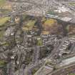
Stirling, Mote Hill


Fort (Iron Age)
Site Name Stirling, Mote Hill
Classification Fort (Iron Age)
Canmore ID 46206
Site Number NS79SE 3
NGR NS 7933 9447
Datum OSGB36 - NGR
Permalink http://canmore.org.uk/site/46206


- Council Stirling
- Parish Stirling
- Former Region Central
- Former District Stirling
- Former County Stirlingshire
NS79SE 3 7933 9447.
(NS 7933 9447) Mote (NR)
OS 6" map (1958)
Fort (NR)
OS 1:1250 map (1967)
There are no intelligible remains of this fort.
Visited by OS (JP) 6 December 1973
Field Visit (16 February 1954)
NS79SE 793944 ("Mote")
Fort, Mote Hill, Stirling (Site).
Mote Hill, the northernmost feature of Gowanhill, consists of a rocky knoll which attains an elevation of about 160 ft. O.D. To the NW. a precipitous cliff falls from the summit to level ground 110 ft. below, but on all other sides the flanks of the knoll are only gently inclined and vary in height from 20 ft. on the N. to 40 ft. on the S. The summit is irregular on plan, measuring 90 ft. in length from N.to S. by 60 ft. from E. to W., and it is probable that the low bank, about 20 ft. in width, that borders it represents the ruin of a wall, although nothing can now be seen to confirm this. An account published in 1794 (1) states that a ruinous wall was then visible and that the stones had the appearance of vitrifaction. A piece of vitrified material from the site is preserved in the Hunterian Museum, University of Glasgow. A later account mentions that the structure was known as Murdoch's Knowe or Hurly Haaky (2), and claims that a second wall lay some 25 ft. outside the first. A vestige of this may be represented by a terrace, 8 ft. in width and 50 ft. in length, which runs across the N. face of the knoll at a level 7 ft. below that of the summit. A pathway climbs gradually up the E. flank of the knoll to reach the summit by way of a sunken gap in the bank. This might mark the position of the original entrance, but it has certainly been used in modern times as the summit now accommodates two iron cannon, a flagstaff, two seats and a boulder fancifully named the ‘Beheading Stone’ (3) mounted on a column.
RCAHMS 1963, visited 16 February 1954.
(1) Randall, A General History of Stirling (1794), 19
(2) TSNHAS, vi (1883-4), 18. Cf. P.S.A.S., vi (1864-6), 210 ff., where this structure is referred to as "Hurly Hackit" and the meaning of the name is discussed.
(3) TSNHAS, ix (1886-7), 59
Field Visit (September 1978)
Mote Hill NS 793 944 NS79SE 3
Little now remains of what may have been a fort defended by two walls situated on the N end of Gowanhill.
RCAHMS 1979, visited September 1978
(RCAHMS 1963, pp. 79-80, no. 80)
Note (15 August 2014 - 8 September 2016)
A small fortification is situated on Mote Hill, which forms the northern most tip of the crags of Gowan Hill to the NE of Stirling Castle. Heavily mutilated, the full extent and history of fortification here is unknown, but excavations by Murray Cook 2013-14 have confirmed the presence of a burnt rampart, which was first identified in 1794 (Randall 1794,19), with a radiocarbon date for its destruction in the early centuries AD. While the size of the fortification has yet to be established, it presumably took in at least the area of the irregular summit, which measures about 27m from N to S by 18m transversely.
Information from An Atlas of Hillforts of Great Britain and Ireland – 08 September 2016. Atlas of Hillforts SC1512

