
Scheduled Maintenance
Please be advised that this website will undergo scheduled maintenance on the following dates: •
Tuesday 3rd December 11:00-15:00
During these times, some services may be temporarily unavailable. We apologise for any inconvenience this may cause.
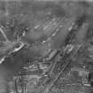
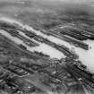
Glasgow, Stobcross, Queen's Dock Entrance, Swing Bridge


Swing Bridge (19th Century)
Site Name Glasgow, Stobcross, Queen's Dock Entrance, Swing Bridge
Classification Swing Bridge (19th Century)
Alternative Name(s) River Clyde; Inner Harbour
Canmore ID 278914
Site Number NS56NE 88.01
NGR NS 56367 65573
Datum OSGB36 - NGR
Permalink http://canmore.org.uk/site/278914


- Council Glasgow, City Of
- Parish Glasgow (City Of Glasgow)
- Former Region Strathclyde
- Former District City Of Glasgow
- Former County Lanarkshire
NS56NE 88.01 56360 65575
For adjacent (to N) hydraulic power station, see NS56NE 88.02.
This bridge formerly crossed the entrance to Queen's Dock (NS56NE 88.00). It had been removed by 1969, at which date the OS 1:1250 map (revised 1968) depicts only the outline of its swinging-pit (on the N side).
Information from RCAHMS (RJCM), 15 February 2006.
Desk Based Assessment (16 June 2017)
This Swing Bridge, which was located at the entrance to the Queen’s Dock (NS56NE 8), was installed when the docks were built (1872-80) and removed in the 1950s. As depicted on the 1:500 OS Town Plan (Glasgow 1894, Sheets VI.10.11; VI.9.10, VI.9.15), it linked the Stobcross Quay on the south with the West Quay on the north. Designed by Sir William Arrol, it was constructed by Sir William Armstrong and Company and could support a weight of up to 60 tons. It was powered from the hydraulic pumping station (NS56NE 88.02) situated nearby to the NW, which also supplied power for the cranes installed on the north quay.
Information from HES Survey and Recording (AMcC) 16 June 2017.

