
Pricing Change
New pricing for orders of material from this site will come into place shortly. Charges for supply of digital images, digitisation on demand, prints and licensing will be altered.
Cardross Battery


Anti Aircraft Battery (20th Century)
Site Name Cardross Battery
Classification Anti Aircraft Battery (20th Century)
Alternative Name(s) An4; Clyde Aa Defences; Murrays
Canmore ID 106353
Site Number NS37NW 19
NGR NS 3370 7728
NGR Description Centred NS 3370 7728
Datum OSGB36 - NGR
Permalink http://canmore.org.uk/site/106353


- Council Argyll And Bute
- Parish Cardross (Argyll And Bute)
- Former Region Strathclyde
- Former District Dumbarton
- Former County Dunbartonshire
NS37NW 19 centred 3370 7728
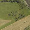
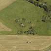
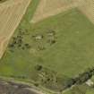
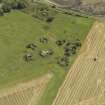
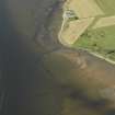
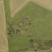
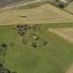
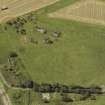
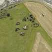
A Second World war anti-aircraft battery situated SW of Cardross to the S of the railway. Consisting of four gun emplacements and a command post with two additional holdfasts and constructed in brick. Evidence of the accommodation camp exists on either side of the track in the form of hut bases. There were no separate magazines and records show that at one stage the battery housed 4.5-inch guns. Some of the emplacements are overgrown and all are in poor condition.
Information from Mr J Guy, August 1996.
Recorded by Mr J Guy as part of the Strathclyde Survey, 2001.
J Guy 2001; NMRS MS 810/11, Part 2, 153-4; Vol.2 (appendix), 14
Post-war vertical aerial photographs (RAF 58A/419 [part two], 5175-76, flown 19 June 1949), show that this heavy anti-aircraft battery was supplied with six gun-emplacements. Four of the emplacements follow the more traditional design pattern whilst two are of a different type. It is likely that the battery was given additional guns at a later stage in the war. Examination of the aerial photographs shows that the battery was also supplied with radar, as the pattern of a Gl-mat with centrally placed ramp is visible on the photographs immediately to the NW of the gun-emplacements. In addition, there are what may be two light anti-aircraft gun positions to the N and S of the heavy gun-emplacements. Two separate magazines can also be seen on the photographs. The six emplacements and the command centre are depicted on the OS 1:10000 scale map (1991).
The accommodation camp consisting of about 33 huts, mainly Nissen, is visible immmediately to the E and N of Murrays farmstead.
Information from RCAHMS (DE), November 2003
Field Visit (2016)
NS 337 772 The site of a WW2 heavy anti-aircraft gun installation was surveyed. Four gun positions are arranged in an arc around an underground command post; all are well preserved. A further two gun positions were identified and these may be the remains of 4.7" guns installed after the usual 3.75" guns described above. A further two gun positions survive as 4m diameter circular concrete pads, details of the gun mounts at each location are preserved. The site therefore appears to have a series of adaptations bringing the total gun positions to eight. The camp buildings and the radar mat area
no longer survive, but are known from aerial photographs of the site. This project is part of a complete survey of military remains along the N Clyde Estuary coastline.
Report: NRHE and WoSAS (intended)
Website: www.spanglefish.com/ NorthClydeArchaeologicalSociety/index.asp
Sandra Kelly – North Clyde Archaeological Society
(Source: DES, Volume 17)

