Pricing Change
New pricing for orders of material from this site will come into place shortly. Charges for supply of digital images, digitisation on demand, prints and licensing will be altered.
Troon, Ballast Bank
Ballast Mound (Period Unassigned)
Site Name Troon, Ballast Bank
Classification Ballast Mound (Period Unassigned)
Alternative Name(s) Troon Harbour, Ballast Mound
Canmore ID 42003
Site Number NS33SW 21
NGR NS 30968 31033
Datum OSGB36 - NGR
Permalink http://canmore.org.uk/site/42003
- Council South Ayrshire
- Parish Dundonald (Kyle And Carrick)
- Former Region Strathclyde
- Former District Kyle And Carrick
- Former County Ayrshire
NS33SW 21 30968 31033
Airport Outer Marker [NAT] (at NS 30916 31108)
Ballast Bank [NAT] (at NS 30970 31053)
Ballast Bank [NAT] (at NS 31013 31013)
Ballast Bank [NAT] (at NS 31099 30927)
Viewfinder [NAT] (at NS 31123 30906)
OS (GIS) AIB, May 2006.
See also NS33SW 23.00.
Formerly entered as Bank (Earthwork) at cited location NS 319 312..
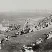
Designed to shield the town from the prevailing winds, the 'Ballast Bank' was constructed from the earth and shingle ballasts of sailing colliers.
J R Hume 1977.
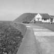
The ballast bank at Troon Harbour (NS33SW 23.00) is a notable and impressive feature, which must be considered a major element of the harbour development and associated housing, to which it affords protection from the prevailing winds and seas (in the SW). Founded on natural sandstone slabs, it has been grassed-over and strengthened with stone and concrete on the seaward (SW) side, where a low sea-wall provides a footpath along the base. It stands an estimated 10m high to a level top, upon which has been set an aircraft navigation beacon and a viewpoint indicator.
Visited by RCAHMS (RJCM), 29 May 2006.
The available map evidence indicates that this feature extends from NS c. 30746 31270 to NS c. 30745 31239 to NS c. 31165 30872 to NS c. 31238 30867, a total distance of just over 650m. Both ends are ramped, and curve towards the NE.
Information from RCAHMS (RJCM), 31 May 2006.


