
Pricing Change
New pricing for orders of material from this site will come into place shortly. Charges for supply of digital images, digitisation on demand, prints and licensing will be altered.
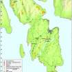
Bute, Stewarthall Wood


Corn Drying Kiln (Period Unassigned)
Site Name Bute, Stewarthall Wood
Classification Corn Drying Kiln (Period Unassigned)
Alternative Name(s) 'Old Kiln Of Kilwhinleck'
Canmore ID 302649
Site Number NS06SE 414
NGR NS 05673 62583
Datum OSGB36 - NGR
Permalink http://canmore.org.uk/site/302649

- Council Argyll And Bute
- Parish North Bute
- Former Region Strathclyde
- Former District Argyll And Bute
- Former County Buteshire
NS06SE 414 05673 62583.
This corn-drying kiln is situated on the sloping SE bank of the Greenan Burn in Stewarthall Wood, some 270m NW of Kilwhinleck farmsteading (NS06SE 30). It comprises a coursed dry-stone bowl, measuring about 2.4m in diameter and up to 1.3m in depth, which is set within an oval mound measuring 6.6m from NE to SW by 5.7m transversely that is partly faced with stone. The flue is in the NW side and a low mound here may represent material removed from it. A slot in the SE side of the mound is probably an excavation trench. The kiln was excavated by J and W Hunter in 1934 and the findings were published in 1935 by J N Marshall.
Visited by RCAHMS (GFG, JMH) 7 May 2009
.
Excavation (1934)
Reference (1935)
Field Visit (7 May 2009)
This corn-drying kiln is situated on the sloping SE bank of the Greenan Burn in Stewarthall Wood, some 270m NW of Kilwhinleck farmsteading (NS06SE 30). It comprises a coursed dry-stone bowl, measuring about 2.4m in diameter and up to 1.3m in depth, which is set within an oval mound measuring 6.6m from NE to SW by 5.7m transversely that is partly faced with stone. The flue is in the NW side and a low mound here may represent material removed from it. A slot in the SE side of the mound is probably an excavation trench. The kiln was excavated by J and W Hunter in 1934 and the findings were published in 1935 by J N Marshall.
Visited by RCAHMS (GFG, JMH) 7 May 2009
.

