
Pricing Change
New pricing for orders of material from this site will come into place shortly. Charges for supply of digital images, digitisation on demand, prints and licensing will be altered.
Bute, Etterick Smithy


School (Period Unassigned), Smithy (Period Unassigned)
Site Name Bute, Etterick Smithy
Classification School (Period Unassigned), Smithy (Period Unassigned)
Alternative Name(s) Kilmachalmaig School
Canmore ID 233610
Site Number NS06NW 86
NGR NS 04088 66782
Datum OSGB36 - NGR
Permalink http://canmore.org.uk/site/233610


- Council Argyll And Bute
- Parish North Bute
- Former Region Strathclyde
- Former District Argyll And Bute
- Former County Buteshire
NS06NW 82.00 04088 66782
NS 040 667 Site 142 Kilmachalmaig School
This former SPCK school, in record from 1772 stood on or close to the site of the Old Smithy which is now a dwelling house. No remains have been found. There were 75 pupils in 1802. In 1845 the school moved to a new building at Kildavanan.
Proudfoot and Hannah 2000
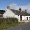
Mackinlay's map of North Bute (1823) depicts a school, which was funded by the Society for Promoting Christian Knowledge, on the site now occupied by a former smithy, now a private house. The school was one of fifteen in the parish of Rothesay, which at that time extended to cover the whole of the north of the island (NSA, Craig, 1840, 114). In 1845 the school moved to a new building at Kildavanan (NS06NW 105), some 1.5km to the SW. In all likelihood the schoolhouse continued in use as a residence for the smith and the former schoolroom as his workshop.
Information from RCAHMS (GFG) 1 Oct 2009.
NS06NW 86.00 NS 04088 66782
NS06NW 86.00 NS 04079 66779 Smithy Cottage
Antiquarian Mapping (1823)
Desk Based Assessment (2000)
NS 040 667 Site 142 Kilmachalmaig School
This former SPCK school, in record from 1772 stood on or close to the site of the Old Smithy which is now a dwelling house. No remains have been found. There were 75 pupils in 1802. In 1845 the school moved to a new building at Kildavanan.
Proudfoot and Hannah 2000
Desk Based Assessment (1 October 2009)
Mackinlay's map of North Bute (1823) depicts a school, which was funded by the Society for Promoting Christian Knowledge, on the site now occupied by a former smithy, now a private house. The school was one of fifteen in the parish of Rothesay, which at that time extended to cover the whole of the north of the island (Craig 1840, 114). In 1845 the school moved to a new building at Kildavanan (NS06NW 105), some 1.5km to the SW. In all likelihood the schoolhouse continued in use as a residence for the smith and the former schoolroom as his workshop.
Information from RCAHMS (GFG) 1 Oct 2009.

