
Bute, Cairn Ban


Chambered Cairn (Neolithic), Chambered Long Cairn (Neolithic), Cup Marked Stone (Neolithic) - (Bronze Age)
Site Name Bute, Cairn Ban
Classification Chambered Cairn (Neolithic), Chambered Long Cairn (Neolithic), Cup Marked Stone (Neolithic) - (Bronze Age)
Alternative Name(s) Carnbaan
Canmore ID 40370
Site Number NS06NW 7
NGR NS 00664 69033
Datum OSGB36 - NGR
Permalink http://canmore.org.uk/site/40370


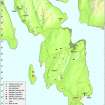


- Council Argyll And Bute
- Parish North Bute
- Former Region Strathclyde
- Former District Argyll And Bute
- Former County Buteshire
NS06NW 7 00632 69316.
(NS 0063 6930) Cairn Ban (NR)
OS 6" map (1957)
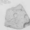
Carnbaan: This Clyde-type long cairn is situated at 300ft OD, on a sloping hillside. It lies E-W across the contour. Before 1820, a stone and turf wall with a ditch on the NE side was built across the NE end, destroying any features NE of it. From the wall, the cairn is 173ft long; the width is about 30ft, but may really be greater as a considerable quantity of leaf mould covers the real edges. The cairn is made of rounded boulders, free of soil, 4ft high; it has been much robbed and disturbed.
An amount of greatly disturbed cairn material stretches for 19ft in front of the wall; a mid-19th century account describes this cairn as extending 25ft in front of the wall. A stone, over 5ft long set on edge in this area may well be part of a frontal facade. There has been a chamber at each end of the cairn aligned along its main axis, and at least one lateral chamber on the SE side. Blain (1880) seems to imply that there were formerly more lateral chambers, but two later attempts to find them have failed (T H Bryce 1904; J Mackinlay 1862). However, at 62ft from the wall, there appears to be the remains of a trench running E-W across the cairn, which is more disturbed here, with various slabs lying about, as well as one which seems to be earthfast, all of which suggests the former presence of a chamber.
A S Henshall 1972; J K Hewison 1893
A chambered long cairn, almost completely overgrown, but generally as described in the previous information. The western chamber, which measures 1.5m by 1.0m with a height of 1.0m, is intact with its capstone still in place. The lateral chamber measures 1.4m by 0.8m and is 0.7m high. Its capstone lies just to the south. The chamber at the east end is partially obscured by a modern field wall, but appears to have measured 1.5m by 0.7m with a height of 0.8m. No remains of a facade can be recognised. There is a short length of modern trench running E-W along the middle of the cairn but there is no suggestion of any additional chamber. The name Cairn Ban was confirmed locally.
Surveyed at 1/10,000.
Visited by OS (BS) 20 October 1976
Lenihuline, Cup Marks, NS 006 693: 15 cup marks on lintel stone which has collapsed over the chamber of the Neolithic burial cairn (Henshall BUT 3).
D Bodys DES 1986 p26.
Kilmichael, Cairn Baan, Capstone of Cist, NS 00668 69333: A minimum of 12 cups, one cut at lower edge suggesting the lintel has been reused.
Jessica Herriot, Balmory Cottage, Ascog, 2009.
This chambered cairn, which is situated in a clearing in woodland, appears to be as described by the previous authorities. It was heavily overgrown on the date of visit.
Visited by RCAHMS (ARG, IP) 19 March 2009.
Excavation (1833)
Reference (1855)
Field Visit (1864)
Field Visit (1893)
Field Visit (1903)
Field Visit (20 February 1962)
Carnbaan: This Clyde-type long cairn is situated at 300ft OD, on a sloping hillside. It lies E-W across the contour. Before 1820, a stone and turf wall with a ditch on the NE side was built across the NE end, destroying any features NE of it. From the wall, the cairn is 173ft long; the width is about 30ft, but may really be greater as a considerable quantity of leaf mould covers the real edges. The cairn is made of rounded boulders, free of soil, 4ft high; it has been much robbed and disturbed.
An amount of greatly disturbed cairn material stretches for 19ft in front of the wall; a mid-19th century account describes this cairn as extending 25ft in front of the wall. A stone, over 5ft long set on edge in this area may well be part of a frontal facade. There has been a chamber at each end of the cairn aligned along its main axis, and at least one lateral chamber on the SE side. Blain (1880) seems to imply that there were formerly more lateral chambers, but two later attempts to find them have failed (T H Bryce 1904; J Mackinlay 1862). However, at 62ft from the wall, there appears to be the remains of a trench running E-W across the cairn, which is more disturbed here, with various slabs lying about, as well as one which seems to be earthfast, all of which suggests the former presence of a chamber.
A S Henshall 1972; J K Hewison 1893
Field Visit (20 October 1976)
A chambered long cairn, almost completely overgrown, but generally as described in the previous information. The western chamber, which measures 1.5m by 1.0m with a height of 1.0m, is intact with its capstone still in place. The lateral chamber measures 1.4m by 0.8m and is 0.7m high. Its capstone lies just to the south. The chamber at the east end is partially obscured by a modern field wall, but appears to have measured 1.5m by 0.7m with a height of 0.8m. No remains of a facade can be recognised. There is a short length of modern trench running E-W along the middle of the cairn but there is no suggestion of any additional chamber. The name Cairn Ban was confirmed locally.
Surveyed at 1/10,000.
Visited by OS (BS) 20 October 1976
Reference (2001)
Field Visit (19 March 2009)
Lenihuline, Cup Marks, NS 006 693: 15 cup marks on lintel stone which has collapsed over the chamber of the Neolithic burial cairn (Henshall BUT 3).
D Bodys DES 1986 p26.
Kilmichael, Cairn Baan, Capstone of Cist, NS 00668 69333: A minimum of 12 cups, one cut at lower edge suggesting the lintel has been reused.
Jessica Herriot 2009.
This chambered cairn, which is situated in a clearing in woodland, appears to be as described by the previous authorities. It was heavily overgrown on the date of visit.
Visited by RCAHMS (ARG, IP) 19 March 2009.
Measured Survey (13 October 2010)
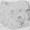
Measured drawings of fragments of the cup marked stone slab, held at Bute museum.
Note (26 June 2018)
Date Fieldwork Started: 26/06/2018
Compiled by: Rock Art Bute
Location Notes: This cup marked panel is a former capstone lying across a turf and stone dyke at the eastern end of the much disturbed Neolithic chambered long cairn of Cairn Ban in the north eastern corner of South Lenihuline Wood, which comprises mature mixed woodland. A footpath leads downhill from the cairn towards the track running NW along the shore from the parking area at Glecknabae to Kilmichael. Two fragments have broken off the capstone and these were removed for safe-keeping to Bute Museum in Rothesay some years ago (accession nos. A18-0480A+B).
Panel Notes: The panel is a former cist cover, toppled over and lying at an angle of about 50 degrees. It measures 2.5m x 0.7m with a thickness of 0.2m. There are 10 cup marks on the W edge of the panel, one of which has been cut through the middle. Two further fragments known to have been part of this panel were removed to Bute Museum in Rothesay some years ago: accession no. A18-0480A, the larger of the two fragments, has 4 complete cup marks and 3 partial cup marks (on the edges); accession no. A18-0480B, the smaller fragment, has 1 shallow complete cup mark and 4 partial cupmarks (on edges).

