
Scheduled Maintenance
Please be advised that this website will undergo scheduled maintenance on the following dates: •
Tuesday 3rd December 11:00-15:00
During these times, some services may be temporarily unavailable. We apologise for any inconvenience this may cause.
Bute, St Blane's


Building (Period Unassigned)
Site Name Bute, St Blane's
Classification Building (Period Unassigned)
Canmore ID 318526
Site Number NS05SE 5.29
NGR NS 09434 53508
Datum OSGB36 - NGR
Permalink http://canmore.org.uk/site/318526


- Council Argyll And Bute
- Parish Kingarth
- Former Region Strathclyde
- Former District Argyll And Bute
- Former County Buteshire
Field Visit (20 March 2012)
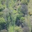
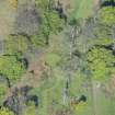
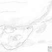
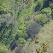
This building is situated immediately S of ‘The Cauldron’ (NS05SE 8). Rectangular on plan, with an entrance in its SE end, it measures up to 5.55m from NW to SE by 3.7m transversely within wall-footings of varying thickness up to 1.9m on the NE and SE. The interior, which has been cleared out, has been set into the slope on the NW and SW, where the walls act as revetments to the scree slope.
Visited by RCAHMS (JRS), 20 March 2012.

