
Scheduled Maintenance
Please be advised that this website will undergo scheduled maintenance on the following dates: •
Tuesday 3rd December 11:00-15:00
During these times, some services may be temporarily unavailable. We apologise for any inconvenience this may cause.
Dun Buidhe


Fort (Prehistoric)
Site Name Dun Buidhe
Classification Fort (Prehistoric)
Canmore ID 39411
Site Number NR88NW 1
NGR NR 80173 89355
NGR Description Centre
Datum OSGB36 - NGR
Permalink http://canmore.org.uk/site/39411


- Council Argyll And Bute
- Parish North Knapdale
- Former Region Strathclyde
- Former District Argyll And Bute
- Former County Argyll
NR88NW 1 8018 8934.
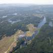
NR 802 892: Dun Buidhe occupies the summit of a high, almost conical crag with a good outlook. Its remains comprise a round citadel, c. 30' in diameter, with two curving terraces below to the N. A Forestry Commission fire look-out hut is built on a stone base, overlying tumble. Footings in cleft to SW; terrace walling massive.
M Campbell and M Sandeman 1964.
NR 8018 8936: The summit of Dun Buidhe is occupied by the much reduced remains of a fort. The summit area measures 46.0m NE-SE by 17.0m and was originally enclosed on the N and W by a wall of which all that survives are several outer facing stones on the N. On the E and S rock faces provide adequate defence. The entrance lies on the N. On the N and W where access is easiest a grass-covered terrace 3.0m wide and up to 2.5m high runs around the hill. It is difficult to assess its relationship to the fort, since it is covered by afforestation, but it probably represents a lower defence. An access path has been built over this terrace to the look-out tower on the summit.
Surveyed at 1:10,000.
Visited by OS (D W R) 29 May 1973.
A fort, surviving generally as described. The only structural remains are a few probable facing stones on the north, the hilltop being otherwise completely grass-covered.
Surveyed at 1/10,000.
Visited by OS (B S) 22 March 1977.
All natural, or insufficient remains to be certain.
Information from RCAHMS (JNGR) December 1986.
NR 800 880 A programme of fieldwork in January and February 2005 followed a desk-based assessment of sites and monuments within North Knapdale Forest, listed in the Forestry Commission heritage database. The survey concentrated on sites that had prehistoric potential or sites about which little was known. In total, 55 sites were visited and briefly recorded. Prehistoric sites of note include a prominent cup-marked boulder, and a probable burial cairn with possible associated cist. Four small defended structures or duns were identified during the survey. Two of these had previously been recorded as duns or forts, but had subsequently been dismissed as natural features, while the other two structures appear to be previously unknown. Of the sites belonging to the later historical period, a possible mill site was discovered, although the majority of the sites appear to relate to later agricultural settlement.
Prehistoric sites - Duns
Structures at Branagad (NR 79866 86794) and Balure (NR 7 8270 85750) have only recently come to light during forestry operations. The structures at Dunans (NR89SW 9) and Dun Buidhe (NR88NW 1) need to be reinstated as probable defended structures, as their nature had been questioned in more recent times; at both sites the remnants of walls were partially revealed during the survey.
NR 80180 89340 What appears to be a rock-cut basin lies close to the possible dun site at Dun Buidhe, and may be related. However, its position at the edge of a large vertically sided rock suggests the basin was not very practical to use on a daily or domestic basis.
Reports to be lodged with WoSAS SMR and NMRS.
Sponsor: Forestry Commission.
R Regan 2005
NR88NW 10 NR 800 880
NR 800 880 A programme of fieldwork in January and February 2005 followed a desk-based assessment of sites and monuments within North Knapdale Forest, listed in the Forestry Commission heritage database. The survey concentrated on sites that had prehistoric potential or sites about which little was known. In total, 55 sites were visited and briefly recorded. Prehistoric sites of note include a prominent cup-marked boulder, and a probable burial cairn with possible associated cist. Four small defended structures or duns were identified during the survey. Two of these had previously been recorded as duns or forts, but had subsequently been dismissed as natural features, while the other two structures appear to be previously unknown. Of the sites belonging to the later historical period, a possible mill site was discovered, although the majority of the sites appear to relate to later agricultural settlement.
Prehistoric sites
Duns
Structures at Branagad (NR 79866 86794) and Balure (NR 78270 85750) have only recently come to light during forestry operations. The structures at Dunans (NR89SW 9) and Dun Buidhe (NR88NW 1) need to be reinstated as probable defended structures, as their nature had been questioned in more recent times; at both sites the remnants of walls were partially revealed during the survey.
Rock art sites
NR 76391 92882 Situated along Dounie ridge is a cup-marked rock with at least 16 cup marks on its upper surface. The site may hold more significance if the apparently heaped stones at the base of the rock prove to be the remains of cairn material. This is the second such site recently located along the eastern side of Dounie ridge; the other lying to the N, situated on a sloping E-facing natural outcrop, bearing several cups and associated rings. NR 80180 89340 What appears to be a rock-cut basin lies close to the possible dun site at Dun Buidhe, and may be related. However, its position at the edge of a large vertically sided rock suggests the basin was not very practical to use on a daily or domestic basis.
Cairn
NR 78245 93085 An exception to the general pattern of clearance cairns uncovered during the survey was a cairn listed at 'Arichonan'. This appears to be a denuded burial cairn, possibly with a central cist.
Medieval/post-medieval sites
Clearance cairns, dykes and fields
Many of the sites visited appear to relate to former settlement sites that could be identified from the 1st and 2nd edition OS maps. Throughout the survey, the presence of enclosure dykes, clearance cairns and the general topography suggested former cultivated areas or fields.
Probable field areas were noted at Ardnackaig (NR 74200 90600), Sailean Mor (NR 74700 90950), Arinafad (NR 75841 89401), Barnluasgan (NR 79700 91600), Glen Sabhall (NR 76007 91272) and Glenyalavon (NR 77830 90960). An unusual form of dyke/enclosure was seen at Lagan (NR 79500 87200), where a series of large upright stones lined the old road to the settlement, the stones possibly keeping livestock from wandering into surrounding fields.
Groups of cairns were located at Sailean Mor, possibly associated with the deserted settlement of Tigh-na-t-sluichd. Several clearance cairns were also noted near the deserted settlement of Glenyalavon (NR 7827 90891) and at Achnamara (NR 78000 86980).
?Mill site
NR 78540 85290 A site located near the deserted settlement of Balure appears to be the remains of a culvert and possible dam embankment. The presence of a large broken millstone suggests this may be part of a mill complex utilising the outflow of Lochan Laraiche.
Jetties
NR 76603 88944; NR 76617 88954 The former settlement of Oibmore appears to have been serviced by two jetties on Loch Caol Scotnish; these linked to the settlement by a track depicted on the 1900 2nd edition OS map.
Shielings
Although numerous sites are listed as shielings in the Forestry Commission database, few were visited during this survey. Of these only one, located in Gleann Sabhall (NR 76007 91272), appears to be a 'classic' shieling structure.
Other sites
Several sites defy interpretation without further investigation. A drystone platform (NR 77097 89744) was located on the eastern bank of Caol Scotnish. This could represent a charcoal stance, although its relatively inaccessible position may mitigate against this interpretation. Also difficult to categorise was a previously unrecorded level circular spread of stones near the coast at Ardnackaig (NR 74191 90599). This feature could represent a collapsed circular structure or a denuded cairn.
Reports to be lodged with WoSAS SMR and NMRS.
Sponsor: Forestry Commission.
R Regan 2005
Field Visit (April 1984)
The summit of Dun Buidhe, a precipitous rocky ridge about 1.5km SSW of Dunans, was examined for traces of fortification; the features that had formerly been recorded, however, were thought to be natural, and no traces of any prehistoric structure were noted.
RCAHMS 1988, visited April 1984.
Note (28 October 2014 - 23 May 2016)
What may be the remains of a small fortification are situated on the summit of Dun Buidh, a precipitous crag that in more recent times has been used as a vantage point for a forest fire watchtower. The most coherent description is provided by the OS, who suggested that the interior measured about 46m from NE to SE by 17m transversely (0.06ha) within a heavily reduced wall that could be traced around the N and W, and they believed that a lower scarp up to 2.5m high around these flanks was probably the remains of an outer wall. They placed the entrance on the N.
Information from An Atlas of Hillforts of Great Britain and Ireland – 23 May 2016. Atlas of Hillforts SC2454
Field Visit (28 February 2019)
The location, classification and period of this site have been reviewed.

