Following the launch of trove.scot in February 2025 we are now planning the retiral of some of our webservices. Canmore will be switched off on 24th June 2025. Information about the closure can be found on the HES website: Retiral of HES web services | Historic Environment Scotland
Kilmartin Glen and North Knapdale Archaeological Survey


Date January 2019 - July 2020
Event ID 1048426
Category Project
Type Project
Permalink http://canmore.org.uk/event/1048426
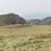
An archaeological survey of 111 km² in Kilmartin Glen and North Knapdale [1] was undertaken by Historic Environment Scotland between January 2019 and July 2020. The survey formed part of the Rapid Archaeological Mapping Programme, a research and development project designed to develop processes and protocols for the economic and rapid enrichment of the National Record of the Historic Environment (NRHE), drawing heavily on high-resolution remote-sensing data. The aims of the survey were (i) to enhance the NRHE for the study area through a mixture of record revision and the identification of new sites and (ii) to further develop procedures for rapid archaeological mapping of large areas that emphasise speed and economy and foreground the use of remote-sensed data.
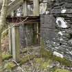
The survey encompassed an area from Loch Crinan in the west to Lochgilphead in the east, and from Ardrishaig in the south to Carnasserie in the north, including large areas dominated by coniferous plantation, the peat-covered landscape of the Mòine Mhòr, and Kilmartin Glen, with the rugged landscapes that lie to its east and west. The survey was mainly concerned with discrete archaeological features, with a particular focus on those that can be shown to pre-date the first edition of the OS 6-inch map, surveyed in the 1860s. Later features that have been abandoned were also included on a discretionary basis, but no attempt was made to record relict features later in date than c.1900. Roofed buildings and related architectural monuments, as well as most cultivation remains, trackways, and other landscape-scale features were omitted.
The survey specification was designed to ensure rapid coverage and to meet the minimum requirements [2] for data entry into the NRHE. Each site was assigned a location (as a centre point and a site-area polygon), classification(s) [3], and period(s), recorded in line with the specification for Level 2 in the HES Levels of Survey. The project included revision of the existing archaeological records within the study area, analysis of remote-sensing datasets in a GIS environment, and a phase of targeted fieldwork.
The project area was identified to make extensive use of two partially coincident Airborne Laser Scanning (ALS) datasets. The first dataset comprised high-resolution data commissioned by HES and collected in March 2017. This covers about 50.5 km² in the central part of Kilmartin Glen, and has a point density of about 50 last returns/m² and an average ground point density of 24/m². The second dataset comprised low-resolution data covering 75.5 km² of North Knapdale and the lower reaches of Kilmartin Glen. It was collected between March 2011 and May 2012, during Phase 1 of ALS data acquisition commissioned by a consortium of the Scottish Government, the Scottish Environment Protection Agency, and Scottish Water. This provided an overall point density of about 2/m² and an average ground point density of about 1/m². Both ALS datasets were processed by HES from LAS files to generate digital terrain models (DTM) with a resolution of 0.25 m for HES data, and 0.5 m for Scottish Government data. Visualisations of each DTM were subsequently produced using the Relief Visualisation Toolbox [4].
In early 2019, desk-based mapping in a QGIS environment was undertaken by David Cowley, Angela Gannon and Dr George Geddes. ALS datasets were viewed using three composite DTM visualisations: (a) Sky-view Factor superimposed on Slope Aspect and Multiple Hillshade; (b) Local Dominance superimposed on Sky-view Factor and Multiple Hillshade; and (c) Sky-view Factor superimposed on Positive Openness. Vertical aerial photographs taken in 2010 (provided by NextPerspectives through Pan Government Agreement), 2015 and 2016 (supplied by Getmapping plc through the APGB agreement) were also used to provide additional information, as were successive iterations of the Ordnance Survey’s Historic Maps (supplied by the National Library of Scotland).
Previously known sites were polygonised using the technical guidance [5] for the Canmore Mapping Layer [6]. Core information on existing sites was enhanced on the basis of the remote-sensing datasets listed above, as well as the information provided in the NRHE, with occasional reference to collections held in the HES Archive, including those of the Royal Commission on the Ancient and Historic Monuments of Scotland (RCAHMS), the Ordnance Survey, and other manuscript sources. Classification and period terms were drawn from existing HES nomenclature. New desk-based identifications were marked a high or low confidence, to inform the second stage of the project.
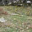
The second stage of the project comprised three weeks of fieldwork in February and March 2019, carried out by Dr Lukasz Banaszek, Georgina Brown, David Cowley, Angela Gannon, Dr George Geddes, Dr Alex Hale, Alison McCaig, and Peter McKeague. Fieldwork was undertaken in instances where the location, classification or period of the site in question (whether known or a new identification) might have been improved. Patterns of walking that explored gaps in the coverage of ALS data, for example along forested burn gulleys, were also encouraged, and the routes of all staff were documented by GPS. In addition, Dr Jim Harold (Visiting Lecturer at Glasgow School of Art) accompanied the field team with the aim of undertaking creative responses to the fieldwork. A final phase of work was undertaken in mid-2020.
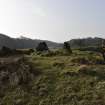
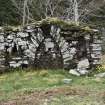
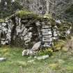
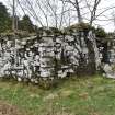
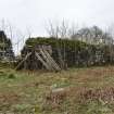
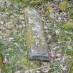
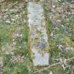
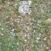
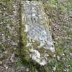
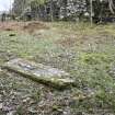
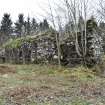
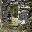
This survey has seen the revision of 198 pre-existing site records, with 92 of those sites benefiting from a field visit. Five existing site records were cancelled, due to duplication or errors in the original data. In addition, the survey added 207 previously unknown sites, including 117 identified solely from desk-based interpretation, 51 desk-based identifications that were subsequently visited, and 39 sites that were identified solely during fieldwork.
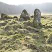
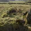
The majority (191) of the newly identified sites are of post medieval or modern date (identified here as post-c.1600 AD), and these include 14 farmsteads, four townships and 30 shieling huts or groups thereof. The eleven prehistoric sites identified include six groups of cup-marked stones and rocks, a hut circle with adjoining field system (Canmore ID 364641) and four burial cairns, two of which are probably of Bronze Age date (Canmore IDs: 364590, 364596, 364628, 364673). The dates for the remaining five newly identified sites could not be established during fieldwork.
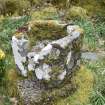
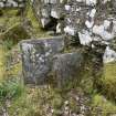
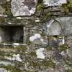
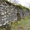
The survey archive includes the spatial data and layers created during desk-based mapping [7] and subsequent survey data processing [8, 9, 10], GPS tracks [11], the metadata for the ALS processing and visualisations [12, 13], and the extent of survey area [14]. 387 digital photographs captured during fieldwork have been added to the NRHE. Final quality assurance and review was undertaken in June 2020 and the project dataset was entered into the NRHE in July 2020.
Information from HES (LB) 17 July 2020.
[1] https://canmore.org.uk/collection/2077034
[2] https://canmore.org.uk/sites/default/files/Minimum%20Record%20Standard%20Feb%202020.pdf
[3] https://canmore.org.uk/thesaurus
[4] https://iaps.zrc-sazu.si/en/rvt#v
[5] https://canmore.org.uk/sites/default/files/HES%20Technical%20Guide%2001-%20Polygons%20-%202015_0.pdf
[6] https://canmore.org.uk/content/data-downloads
[7] https://canmore.org.uk/collection/2063636
[8] https://canmore.org.uk/collection/2063637
[9] https://canmore.org.uk/collection/2063638
[10] https://canmore.org.uk/collection/2063639
[11] https://canmore.org.uk/collection/2063634
[12] https://canmore.org.uk/collection/2063631
[13] https://canmore.org.uk/collection/2063632
[14] https://canmore.org.uk/collection/2063635