
Pricing Change
New pricing for orders of material from this site will come into place shortly. Charges for supply of digital images, digitisation on demand, prints and licensing will be altered.
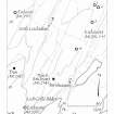
Barnluasgan


Enclosure (Period Unknown), Hut Circle (Prehistoric)(Possible)
Site Name Barnluasgan
Classification Enclosure (Period Unknown), Hut Circle (Prehistoric)(Possible)
Canmore ID 39171
Site Number NR79SE 2
NGR NR 79360 92296
NGR Description Centre
Datum OSGB36 - NGR
Permalink http://canmore.org.uk/site/39171


- Council Argyll And Bute
- Parish North Knapdale
- Former Region Strathclyde
- Former District Argyll And Bute
- Former County Argyll
NR79SE 2 7934 9228.
(NR 7935 9230) Circle (NR)
OS 6" map, Argyllshire, 2nd ed., (1924)
A small circle, composed of a few stones; its use is not known.
Name Book 1867.
A hut circle, 18' in diameter.
J H Craw 1930.
The "circle" is situated on a level terrace and appears for the most part to be the remains of a small enclosure. Only the SE arc of its wall is left, consisting of about eight inner facing stones, suggesting a measurement of about 9.0m across. The site is too denuded to classify.
Visited by OS (DWR) 23 May 1973.
No change to the report of 23 May 1973.
Visited by OS (TRG) 26 January 1977.
Resurveyed at NS 7934 9228.
Information from I Parker (RCAHMS).
NR 79361 92291 Site identified during a field survey carried out by GUARD in 2003. This structure has three stones on the east side, up to 0.5m high, forming a slight arc and is continued with a very slight, discontinuous bank forming a circular feature 8.9m in diameter.
Heather F James, 2003 (RCAHMS MS 2371, no.98)
Field Visit (May 1984)
NR 793 923
The slight remains of an enclosure about 10m in internal diameter lie on a grassy shelf on the side of a ridge 1.25km NNE of Barnluasgan; an arc of boulders on the E indicates the line of the inner face and a scattered band of rubble, obscured by vegetation, marks the remainder of the circuit. The position of the entrance is unknown.
Visited May 1984
RCAHMS 1988 No. 331 (1)
Field Visit (1 March 2019)
The location, classification and period of this site have been reviewed.

