
Pricing Change
New pricing for orders of material from this site will come into place shortly. Charges for supply of digital images, digitisation on demand, prints and licensing will be altered.
Dun Mor


Fort (Prehistoric)
Site Name Dun Mor
Classification Fort (Prehistoric)
Alternative Name(s) 170 Fort; Dunmore
Canmore ID 38977
Site Number NR76SE 1
NGR NR 7925 6192
Datum OSGB36 - NGR
Permalink http://canmore.org.uk/site/38977


- Council Argyll And Bute
- Parish South Knapdale
- Former Region Strathclyde
- Former District Argyll And Bute
- Former County Argyll
NR76SE 1 7925 6192.
(NR 7925 6194) Fort (NR)
OS 6" map, (1924)
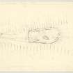
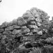
Fort, Dunmore: This sub-oval fort occupies the NE half of a narrow rocky summit. It is bounded by a single stone wall enclosing an area 140' x 70', with an entrance at each end. Along the NW side, and at the rounded NE end, the wall is built on the outer margin of the summit, but on the SE side it diverges from it to follow the line of a prominent spine of outcrop for 90' before turning squarely across the ridge to form the straight SW end. The wall is of stone-faced rubble construction; considerable sections of both faces remain, though in several places, especially on N and NW, the outer face has collapsed down the slope, and much of the inner face is obscured. Both faces stand over 4' high on the SE; the best preserved piece of outer face lies between the SW entrance and the SW angle, where it is 5' high. The wall thickness varies from 12' on the W and NW to 6'6" on the E and S, but this may be due to rebuilding. Other wall features also suggest reconstruction. On the SE, the thickness appears to increase suddenly to 12' where a stretch of inner face is visible for a length of 13'. The wall at this point is so disturbed and overgrown that it is impossible to ascertain whether this wider portion is part of the thinner wall on either side of it or belongs to a different phase of construction. Again, towards the SW end of the NW side, opposite a break in the inner face of the wall, and set back 6' from it, a short piece of facing can be seen among the core material. Without excavation, the true nature of this feature cannot be explained; it may be part of a medial face, or even a mural cell, but could also signify a repairing or re-inforcing of the wall. At both entrances, on NE and SW, the wall has been severely robbed and most of the facing stones and core material have been removed.
The interior of the fort is uneven; two structures can be distinguished - both seem secondary, and may possibly be associated with each other. The first consists of the very fragmentary foundations of what has probably been a small building or hut. Sufficient facing stones remain to indicate a rectangular outline with rounded corners, 20' x 10' within a 3' - 4' thick wall. The entrance position is uncertain. The second feature, near the SW end of the fort, appears as a ragged band of stones spread to 5' wide, representing all that remains of a collapsed wall, springing from the inner face of the fort wall on the SE, and running W for 30' to merge with the heavy mass of tumble NW of the entrance. It appears to have no facing stones; its slight construction and odd relationship to the fort wall clearly indicate its secondary nature. There is an outer defence at the SW end of the summit area. It consists of a wall drawn across the ridge top in a gentle arc, ending abruptly at either end on the natural crest-line. It is now reduced to an over- grown scatter of stones, with two pieces of outer face visible. No inner face is visible, but judging from the width of the scatter, the wall thickness would be c. 6'. There is no sign of an entrance.
Information from RCAHMS Ms, visited 1959.
The fort is generally as described by RCAHMS, although fallen trees and vegetation obscure many details.
The scatter of stone to the SW is too slight to identify as an outwork. Surveyed at 1:10,000.
Visited by OS (D W R) 26 May 1973.
No change to the report of 26 May 1973.
Surveyed at 1/10,000 on MSD.
Visited by OS (B S) 8 March 1977
Field Visit (19 June 1943)
This site was included within the RCAHMS Emergency Survey (1942-3), an unpublished rescue project. Site descriptions, organised by county, vary from short notes to lengthy and full descriptions and are available to view online with contemporary sketches and photographs. The original typescripts, manuscripts, notebooks and photographs can also be consulted in the RCAHMS Search Room.
Information from RCAHMS (GFG) 10 December 2014.
Field Visit (4 May 1959)
Field Visit (May 1982)
This well-preserved fort occupies a position of considerable natural strength on the summit of Dun Mor, an elongated ridge 200m NNE of Dunmore House (Campbell and Sandeman 1964). Aligned NE and SW and subrectangular on plan, it measures 45m by 22m within a stout stone wall up to 4m in thickness. Long stretches of both outer and inner facing-stones survive; on the SW the outer face stands in one place to a height of 1.7m in ten courses and in two sections to heights of 1.7m in eight courses. The builders have made careful use of the natural rocky terraces and spines, the SE side being built along the crest of a spine that rises some 2.5m above a level shelf on the exterior of the fort; on top of the spine the wall still stands with a carefully built batter to a height of 1.1m. On the SE there is also a short curious feature of the inner face, which appears to represent a rebuilding or buttressing of the wall, the face here being some 0.9m high in five courses. There are entrances at the centre of the NE and SW ends of the fort; the inner angle and one side-slab of the SE side of the NE entrance remain in position, but much of the opposite side is hidden by tree roots. The walling at the SW end of the fort has been heavily robbed, and the entrance is now little more than a gap in the rubble. Two hollows in the wall on the SW side appear to be small recent bothies. At the centre of the interior of the fort there is a subrectangular building of no great age. A band of rubble at the SW end is all that remains of a cross-wall which also appears to be comparatively recent in date.
About 44m to the SW of the fort there are traces of an outer wall, now reduced to little more than a band of rubble in which occasional stones of the outer face have remained in position.
Visited May 1982
RCAHMS 1988
Note (14 October 2014 - 17 August 2016)
This subrectangular fort has a relatively well-preserved wall enclosing no more than 0.09ha, but the outer wall, which blocks access to the steep-sided ridge on which it stands, lies some 45m to the SW and cuts off an area of about 0.2ha. The inner fort has entrances on the NE and SW respectively and the footings of a sub-rectangular building can be seen within its interior.
Information from An Atlas of Hillforts of Great Britain and Ireland – 17 August 2016. Atlas of Hillforts SC2282

