
Pricing Change
New pricing for orders of material from this site will come into place shortly. Charges for supply of digital images, digitisation on demand, prints and licensing will be altered.
Montrose Harbour


Harbour (Period Unassigned)
Site Name Montrose Harbour
Classification Harbour (Period Unassigned)
Alternative Name(s) Port Of Montrose; Montrose Basin; River South Esk
Canmore ID 280536
Site Number NO75NW 44
NGR NO 7123 5721
NGR Description Centred NO 7123 5721
Datum OSGB36 - NGR
Permalink http://canmore.org.uk/site/280536


- Council Angus
- Parish Montrose
- Former Region Tayside
- Former District Angus
- Former County Angus
NO75NW 44.00 centred 7123 5721
Harbour [NAT] (at NO 7123 5721)
OS 1:10,000 map, 1984.
NO75NW 44.01 NO 71629 57114 Old Harbour
NO75NW 44.02 NO 71231 57300 West Quay, Old Pier (watching brief, 2001)
NO75NW 44.03 NO 7123 5733 West Quay
NO75NW 44.04 NO 7135 5724 Captain Graham Quay
NO75NW 44.05 NO 7144 5717 Fish Quay
NO75NW 44.06 NO 7153 5706 Andrew Mearns Quay
NO75NW 44.07 NO 71584 57024 Neish's Knuckle, slipway
NO75NW 44.08 NO 7166 5697 J M Piggins Quay
NO75NW 44.09 NO 71779 56916 Beacon
NO75NW 44.10 NO 72121 56970 Lifeboat Station (Lifeboat House)
NO75NW 44.11 NO 72133 56964 Outer Leading Light ('Montrose 2')
NO75NW 44.12 NO 71860 56973 Inner Leading Light ('Montrose 1')
See also:
NO75NW 144.00 centred NO 7142 5684 Ferryden, Inchcape Quay ('Oil Base')
NO75NW 144.01 NO 7163 5673 Ferryden , Old Pier
For Montrose, Ferry Street, Dock Buildings (NO 71621 57220), see NO75NW 45.
For Montroseness (Scurdie Ness) lighthouse (NO 7331 5675), see NO75NW 48.
For Montrose Harbour Defences, see:
NO75NW 131 NO 7264 5676 Scurdie Ness Gun emplacement
NO75NW 132 NO 72470 56756 and NO 72495 56756 Ferryden Gun emplacements
NO75NW 133 NO 7268 5676 Scurdie Ness Gun emplacement
(Location cited as NO 718 568). Air photograph: AAS/97/11/G23/1.
NMRS, MS/712/29.
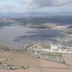
(Location cited as NO 71 57). Montrose: the town of Montrose occupies a broad tongue of land which forms the E side of Montrose Basin. The Basin is a squarish tidal lagoon some 1900 acres [769ha] in extent, through the S part of which runs the channel of the South Esk, to debouch at its SE corner. The river's lowermost reach, a further mile in length, passes the town (NO75NW 33) and reaches the sea between Scurdie Ness [name: NO 735 567] on the S and Annat Sand on the N, the latter being the southernmost point of the long sandy stretch noted above. The town's quays are set on the N bank of this lowermost reach, with the village of Ferryden opposite. The statement (in the Statistical Account) that ships of 50 to 60 tons could come to the E and W sides of the basin is hard to square with the topography, but if the SE and SW corners of the basin are meant, rather than the E and W sides, this record agree with that of 1847 that the tidal river-channel could be used by small craft as far upstream as Old Montrose [name: NO 672 570].
In addition, however, to giving access to inland sites, the Basin evidently played an important part in the functioning of Montrose harbour. The river-mouth reach was difficult to navigate, its entry being noted as dangerous by reason of a sandbank. Silting was kept in check by the flushing action of impounded sea-water, rushing out from the basin and reinforcing the river's flow, at every falling tide. It was consequently essential to retain this tidal reservoir in sufficient volume; and the importance of the matter is shown by the vigorous reaction of the town to attempts by inland proprietors to reclaim parts of the Basin for agricultural purposes, thereby reducing the volume of the water retained on the rise of the tide and proportionately diminishing the force of its outflow on the fall. Thus when a scheme was launched in 1676 for the draining of some land belonging to a former provost, and an appeal for help was made to the Convention of Royal Burghs, that body appointed a committee to report on the likelihood of damage to the harbour, with powers to collaborate, if necessary, with the town's magistrates to get the project stopped. This was probably the same scheme as is recorded in the Statistical Account as having failed through storm-damage before the work was finished; traces of it, with the name Drommers (drainers') Dyke are marked on the OS maps. Further controversy and some litigation attended similar projects in 1817, 1831 and 1841; the last of these would have cut off 10.5 million cu ft [207150 cu m] of water at every spring tide.
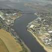
The Macfarlane document mentions a 'good shore' at the town, and this was no doubt a street with a quay-frontage, as at Dundee (NO43SW 109), seeing that Parliamentary or burghal help in repairing the harbour was applied for at least twice in the course of the 17th century. Much shipping used the harbour in the early 18th century, it being regarded in 1793 as the 'most commodious' one between the Tay and Cromarty. At that date there was a good wet dock where ships were built and repaired, and 53 ships were owned there jointly with Ferryden. Smuggling flourished, as everywhere. In 1847, the channel was recorded as 170 yds [155.5m] wide, and as giving a depth from 15 to 18ft [4.6 to 5.5m] at the town quays. In 1837 a wet dock had been built to the plans of J Leslie, with an entrance 55ft [16.8m] and a depth at the sill of from 16 to 19.5ft [4.9 to 5.9m]. Scurdie Ness was still unlighted, and in consequence ships sometimes gave its dangerous rocks too wide a berth, were unable to turn into the mouth of the river, and piled up on the Annat Sand on the N bank. It was noted that a beacon was needed there, and also that some awkward spots in the channel needed to be deepened. Craft drawing up to 8ft [2.4m] could pass the drawbridge, and carry cargoes of lime and coal as far upstream as Old Montrose.
A Graham 1979.
The port of Montrose remains the maritime gateway for its essentially agricultural hinterland in Angus and the Mearns, and has been operated as an independent port by the Montrose Port Authority since 1843. Its principal cargo traffic comprises pulp and timber, paper, fertiliser and agricultural products; Montrose is the largest pulp handling port in Scotland. Shipbuilding and fishing are no longer practised, but Montrose was one of the first ports to develop a support base (the 'oil base': NO75NW 144.00) for offshore oil development.
The port is formed around the mouth of the River South Esk, quayage and other facilities being provided on both the N (Montrose) and S (Ferryden) banks. The narrow entrance to the port normally limits the size of vessels to a maximum length of 164m and draught of 7.3m, although ships of 17,000 dwt and 7.5m draught have been handled. The entrance channel is dredged to minimum width and depth of 5.5m and 50m respectively. Marine services include port radio, towage and (compulsory) pilotage; Port Control is situated in the port office on the S quay.
A wet dock (NO75NW 44.01) was built in 1843 and remained in use until 1981, when it was infilled to serve as a timber storage area. Over 1000m length of quayage is now available, the N quays (comprising berths 6-11) being 550m long and the S quays (comprising berths 12-17) 246m; a further 200m length of the S quay is currently available for redevelopment. The S quay was chiefly built to support the offshore support industry, and opened in 1975; a 220m length is specially constructed to handle loads up to 2000t.
Extensive storage facilities comprise open ground (for general storage and/or fabrication and repair work), warehousing and transit sheds, and a purpose-built grain store (opened in 1990). Up to 500,000 sq ft [464,512 sq m] of warehousing is available, 275,000 sq ft [25,548 sq m] on the N quay and the remainder on the S quay. All this space is lit, and some is heated. Conversion of warehouse facilities has provided additional stores for 9000t of animal feed and 10,000t of grain on the S and N shores respectively.
Up to 300,000t of timber and timber products are handled on the N quay each year, open storage being available. Dry bulk cargoes include grain, which is handled on both banks; elevators, mobile cranes and computerised weighbridges are available. Paper is kept under cover in 375,000 sq ft [34,838 sq m] of quayside warehousing; a new 40,000 sq ft [3,716 sq m] transit warehouse has recently been completed.
[Illustrations include map of port facilities].
C J Smith 2005.
Annat Sands are not noted as such on the 1999 edition of the OS 1:50,000 map. The name probably applies to the extensive sands to the N of the mouth of the River South Esk, around NO 727 572.
Information from RCAHMS (RJCM), 19 April 2006.
Publication Account (2007)
The wet dock at Montrose, constructed from 1839–41, was designed by James Leslie. The dock, a rectangular basin formed of coursed rubble walls, enclosed an area of 312 acres and could accommodate vessels drawing 1912 ft of water at
spring tides and 16 ft at neap tides. It provided 1500 ft ofsheltered quays for the harbour that were sealed from the tidal water of the River South Esk by cast-iron lock gates. In addition the town had about 1700 yards of tidal quays.
Leslie’s dock was filled in from 1980–82, and the harbour is now wholly river berths formed by quay walls and totally tidal. It is mainly used by oil service vessels, and can accommodate boats drawing up to 18–24 ft of water depending on the tide. It is managed by the Montrose Port Authority and its harbour master.
R Paxton and J Shipway 2007b
Reproduced from 'Civil Engineering heritage: Scotland - Highlands and Islands' with kind permission of Thomas Telford Publishers.
Publication Account (2013)
The harbour developed on both sides of the South Esk channel leading from Montrose Basin. The quay edge was extensively rebuilt in 1973-5 and land reclaimed for oil support services on the south, Ferryden, side so that Rossie Island is no longer an island.
James Leslie constructed a small wet dock in 1845 but it was infilled in 1981 to give six acres of storage space on land. The pedimented Harbour Buildings had taken prime position facing that dock, three storeys and a clock, and a four-storey warehouse/ flour mill to the rear. Now they are awaiting a new use.
M Watson, 2013

