
Pricing Change
New pricing for orders of material from this site will come into place shortly. Charges for supply of digital images, digitisation on demand, prints and licensing will be altered.
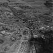
Arbroath, Goods Station


Goods Shed (19th Century) - (20th Century)
Site Name Arbroath, Goods Station
Classification Goods Shed (19th Century) - (20th Century)
Canmore ID 82296
Site Number NO64SW 109
NGR NO 6388 4108
Datum OSGB36 - NGR
Permalink http://canmore.org.uk/site/82296


- Council Angus
- Parish Arbroath And St Vigeans
- Former Region Tayside
- Former District Angus
- Former County Angus
NO64SW 109 6388 4108
See also NO64SW 108.
In the yard on the downside of Arbroath Station is a '...single-storey rubble building with 4 arched entrances, probably the engine shed of the Dundee & Arbroath and Aberdeen railways.'
J R Hume, 1977.
The Dunee and Arbroath Railway company operated services from 1838 and so this 4 bay goods station possibly dates from the 1840s based on the style of the building. The building is depicted on the Ordnance Survey 1st edition 6-inch map (Angus, 1865). The 1st edition 25-inch map (Angus, 1894) depicts three tracks and three turntables to the S of the goods shed. There is a small goods handling crane nearby (NO64SW 108).
This building was photographed by RCAHMS in 2008 due to threat of demolition.
Information from RCAHMS (MMD) 6 June 2008.
This goods station has been demolished.
Information from RCAHMS (MMD), 18 December 2008.

