
Pricing Change
New pricing for orders of material from this site will come into place shortly. Charges for supply of digital images, digitisation on demand, prints and licensing will be altered.
Craigmill


Enclosure (Period Unknown), Rig And Furrow (Medieval) - (Post Medieval)
Site Name Craigmill
Classification Enclosure (Period Unknown), Rig And Furrow (Medieval) - (Post Medieval)
Canmore ID 144286
Site Number NO53NE 78
NGR NO 5789 3588
Datum OSGB36 - NGR
Permalink http://canmore.org.uk/site/144286


- Council Angus
- Parish Panbride
- Former Region Tayside
- Former District Angus
- Former County Angus
NO53NE 78 5789 3588
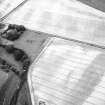
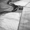
Oblique aerial photographs (RCAHMSAP 1995) show the cropmarks of a large enclosure and rig, immediately to the E of Craigmill farmsteading. The two visible sides of the enclosure measures about 200m by 200m, extending across three fields. On the SE side it is cut by rig-and-furrow cultivation, but on the NE side the rig appears to respect the enclosure. An further patch of rig-and-furrow cultivation runs NW-SE across two fields for about 500m.
Information from RCAHMS (KJ) 28 April 1999.
See also NO53NE 15 and NO53NE 29.

