
Craigmill


Enclosure (Period Unknown), Rig And Furrow (Medieval) - (Post Medieval)
Site Name Craigmill
Classification Enclosure (Period Unknown), Rig And Furrow (Medieval) - (Post Medieval)
Canmore ID 144286
Site Number NO53NE 78
NGR NO 5789 3588
Datum OSGB36 - NGR
Permalink http://canmore.org.uk/site/144286


- Council Angus
- Parish Panbride
- Former Region Tayside
- Former District Angus
- Former County Angus
NO53NE 78 5789 3588
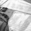
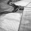
Oblique aerial photographs (RCAHMSAP 1995) show the cropmarks of a large enclosure and rig, immediately to the E of Craigmill farmsteading. The two visible sides of the enclosure measures about 200m by 200m, extending across three fields. On the SE side it is cut by rig-and-furrow cultivation, but on the NE side the rig appears to respect the enclosure. An further patch of rig-and-furrow cultivation runs NW-SE across two fields for about 500m.
Information from RCAHMS (KJ) 28 April 1999.
See also NO53NE 15 and NO53NE 29.

